Arterburn Farm Cemetery
Flippin, Monroe County, Kentucky, USA
About
-
- This cemetery is marked as private and may not be accessible.
- Cemetery ID:
Members have Contributed
Advertisement
Photos
No additional photos.
Add PhotosLocated about 1 mile north of Flippin on Highway 249, about 1/2 mile due east of WARD-LEWIS Cemetery in the middle of the field. Coordinates are approximate. (Restricted access: Contact landowner.)
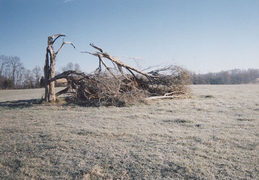
There are several unidentified and unmarked grave sites known to be in this cemetery. Some were once marked with field stones. The cedar tree is gone, destroyed in a storm, but daffodils still come up each spring to mark the original cemetery site.
Elzia Arterburn (#141415355) and Elizabeth Douglass Arterburn (#141415406) and other family members could be here or in WARD-LEWIS CEMETERY, if the latter served as an early burying ground for Bethel M E Church. Recent atDNA evidence has confirmed that Elizabeth's mother (i.e., Elizabeth Ford Douglass) was the daughter of Lloyd Ford and Mary Grant. Lisby Ford's relationship to Elizabeth Ford Douglass is implicated but not yet explicated.
This land (1,442 acres) was surveyed in 1797 by William Wilson, John Raburn, David Wallis, and Daniel Boone for Reid and Pearson, who sold it to Charles Copland, then gifted to the John Goodall family, and later subdivided to John & Ann (Goodall) Martin, 1808-1818. Deed history is missing, 1820-1834. Elzia Arterburn purchased this farm of 175 acres from John Hardin of Mississippi, in 1834. The farm belonged to this Arterburn family through 1906. There could have been other burials here prior to the Elzia Arterburn farm (1834-1906).
Located about 1 mile north of Flippin on Highway 249, about 1/2 mile due east of WARD-LEWIS Cemetery in the middle of the field. Coordinates are approximate. (Restricted access: Contact landowner.)
There are several unidentified and unmarked grave sites known to be in this cemetery. Some were once marked with field stones. The cedar tree is gone, destroyed in a storm, but daffodils still come up each spring to mark the original cemetery site.
Elzia Arterburn (#141415355) and Elizabeth Douglass Arterburn (#141415406) and other family members could be here or in WARD-LEWIS CEMETERY, if the latter served as an early burying ground for Bethel M E Church. Recent atDNA evidence has confirmed that Elizabeth's mother (i.e., Elizabeth Ford Douglass) was the daughter of Lloyd Ford and Mary Grant. Lisby Ford's relationship to Elizabeth Ford Douglass is implicated but not yet explicated.
This land (1,442 acres) was surveyed in 1797 by William Wilson, John Raburn, David Wallis, and Daniel Boone for Reid and Pearson, who sold it to Charles Copland, then gifted to the John Goodall family, and later subdivided to John & Ann (Goodall) Martin, 1808-1818. Deed history is missing, 1820-1834. Elzia Arterburn purchased this farm of 175 acres from John Hardin of Mississippi, in 1834. The farm belonged to this Arterburn family through 1906. There could have been other burials here prior to the Elzia Arterburn farm (1834-1906).
Nearby cemeteries

Flippin, Monroe County, Kentucky, USA
- Total memorials5
- Percent photographed60%
- Percent with GPS60%

Flippin, Monroe County, Kentucky, USA
- Total memorials13
- Percent photographed62%
- Percent with GPS15%

Flippin, Monroe County, Kentucky, USA
- Total memorials11
- Percent photographed82%
- Percent with GPS0%

Flippin, Monroe County, Kentucky, USA
- Total memorials5
- Percent photographed20%
- Percent with GPS20%
- Added: 20 Nov 2015
- Find a Grave Cemetery ID: 2596222

Cemetery Photos
This is a carousel with slides. Use Next and Previous buttons to navigate, or jump to a slide with the slide dots. Use Escape keyboard button or the Close button to close the carousel.
Success
Uploading...
Waiting...
Failed
This photo was not uploaded because this cemetery already has 20 photos
This photo was not uploaded because you have already uploaded 5 photos to this cemetery
This photo was not uploaded because you have already uploaded 5 photos to this cemetery
Invalid File Type
Birth and death years unknown.
1 photo picked...
2 photos picked...
Uploading 1 Photo
Uploading 2 Photos
1 Photo Uploaded
2 Photos Uploaded
Size exceeded
Too many photos have been uploaded
"Unsupported file type"
• ##count## of 0 memorials with GPS displayed. Double click on map to view more.No cemeteries found