Old Thomas Place Graves
Asher, Madison County, Arkansas, USA

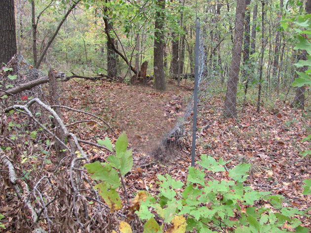
There are two graves marked with tombstones, and four graves marked only with fieldstones. One of the fieldstones has "M A" carved at the top of it and what looks like a "W" below that. This grave has a footstone and appears to be an adult's grave.
The six graves are enclosed within a tall, chainlink fence. There is no gate but at the back side there is a place where you can "unfasten" the fence and enter.
Directions to find these graves:
From Wesley, go two miles east on Highway 74; turn south of Highway 303, and go 8.9 miles. On the right, you will see a metal corral with a barn/metal shed behind it. There is a 5 foot tall, square concrete marker by the gate which reads "Thomas Graves, 150 yards" and has an arrow pointing to the hillside across the creek. To find the graves you must walk through the gate, crawl under the barbed wire fence at the back of the pasture, cross Thomas Creek (which is dry part of the year), and then you will see an old road to your right which goes up the hill. (this road is near a small hollow between the hills) Follow this old road for about 200-300 feet and the graves will be on a level part (bench) of the hill, off to your left about 50 feet from the old road.
Nearby cemeteries

Asher, Madison County, Arkansas, USA
- Total memorials3
- Percent photographed100%
- Percent with GPS0%

Asher, Madison County, Arkansas, USA
- Total memorials3
- Percent photographed33%
- Percent with GPS0%

Japton, Madison County, Arkansas, USA
- Total memorials635
- Percent photographed92%
- Percent with GPS1%

Madison County, Arkansas, USA
- Total memorials212
- Percent photographed92%
- Percent with GPS0%
- Added: 25 Oct 2010
- Find a Grave Cemetery ID: 2375200

Cemetery Photos
This is a carousel with slides. Use Next and Previous buttons to navigate, or jump to a slide with the slide dots. Use Escape keyboard button or the Close button to close the carousel.

Success
Uploading...
Waiting...
Failed
This photo was not uploaded because this cemetery already has 20 photos
This photo was not uploaded because you have already uploaded 5 photos to this cemetery
This photo was not uploaded because you have already uploaded 5 photos to this cemetery
Invalid File Type
Birth and death years unknown.
1 photo picked...
2 photos picked...
Uploading 1 Photo
Uploading 2 Photos
1 Photo Uploaded
2 Photos Uploaded
Size exceeded
Too many photos have been uploaded
"Unsupported file type"
• ##count## of 0 memorials with GPS displayed. Double click on map to view more.No cemeteries found