Original Boistfort Cemetery
Also known as Old Boistfort Cemetery
Boistfort, Lewis County, Washington, USA
About
-
- Cemetery ID:
Members have Contributed
Advertisement
Photos


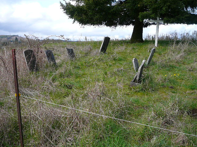
This large mound is on the Old Buchanan Donation land claim. It was
used by all people until the farm was sold in 1887. The new owner removed
the headstones and burned over the ground. He was taken to court and was
refused the right to plow the land but he refused anyone access to the property.
In the 1940's a new owner built a fence around it but it was allowed to
grow up into brush.
Records of the cemetery were burned in a house fire and no one knows the
number of people buried here. Old-timers think there were approximately 70 graves.
The exact location of the graves is not known as the stones had been knocked
over and were just in a pile.
In 1982, out of respect and admiration of the early Boistfort Valley Pioneers, the
Boistfort Lions Club asked permission of the present owner of the property, Leo Walsh,
to clean up the cemetery. Permission was granted and the result is what you see today.
What stones that were found were cleaned and put in place by the Boistfort Lions.
A cross was erected, a fence built, and steps built up the hill.
Directions to the Boistfort Cemetery:
Take exit #77 off of Interstate 5. Go West on Washington Highway #6 for 5.4 miles to
Curtis Hill Road. Take a left onto Curtis Hill Road and go 3.3 miles to Boistfort Road.
Go left on Boistfort Road 4.6 miles. The Boistfort Road changes to the Wildwood Road
at the intersection of the Boistfort Roand and the PeEll-McDonald Road. Go straight
ahead on the Wildwood Road for 3 tenths of a mile. The Boistfort Cemetery is on the
right hand side of the road.
The original Boistfort Burial Grounds is on the lefthand side of the Wildwood Road on
top of the large mound that you see. Access to it is via a path and steps leading from
the pullout on the opposite side of the road from the 1890 cemetery that is used today.
These are the only stones that were found and placed upright again. There could be as many as 70 graves here.
Nearby cemeteries

Boistfort, Lewis County, Washington, USA
- Total memorials283
- Percent photographed94%
- Percent with GPS5%

Bunker, Lewis County, Washington, USA
- Total memorials131
- Percent photographed92%
- Percent with GPS0%

Lewis County, Washington, USA
- Total memorials18
- Percent photographed100%
- Percent with GPS0%

Pe Ell, Lewis County, Washington, USA
- Total memorials346
- Percent photographed76%
- Percent with GPS1%
- Added: 4 Apr 2008
- Find a Grave Cemetery ID: 2256157

Cemetery Photos
This is a carousel with slides. Use Next and Previous buttons to navigate, or jump to a slide with the slide dots. Use Escape keyboard button or the Close button to close the carousel.


Success
Uploading...
Waiting...
Failed
This photo was not uploaded because this cemetery already has 20 photos
This photo was not uploaded because you have already uploaded 5 photos to this cemetery
This photo was not uploaded because you have already uploaded 5 photos to this cemetery
Invalid File Type
Birth and death years unknown.
1 photo picked...
2 photos picked...
Uploading 1 Photo
Uploading 2 Photos
1 Photo Uploaded
2 Photos Uploaded
Size exceeded
Too many photos have been uploaded
"Unsupported file type"
• ##count## of 0 memorials with GPS displayed. Double click on map to view more.No cemeteries found