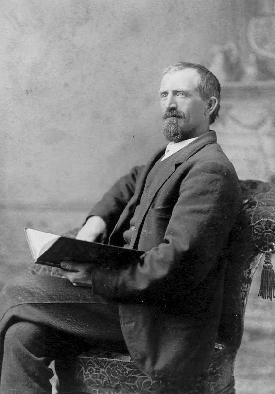
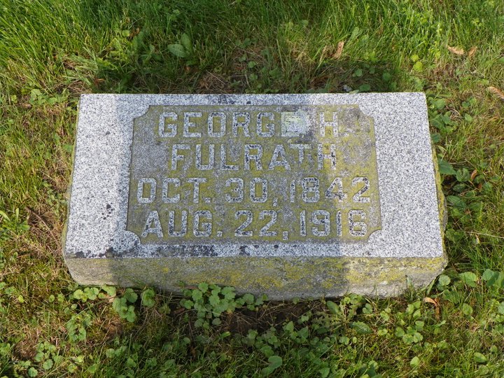
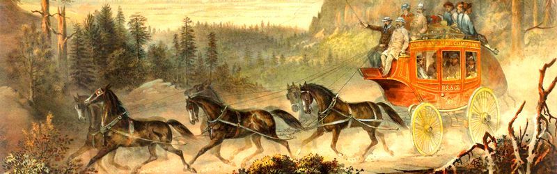
Born in Hesse Darmstadt, Germany, in 1842; he came to America in *1849; lived in Franklin Co., Pennsylvania, for 8 years; came to Carroll Co. in 1857; went to California in 1864; was in the employ of Wells & Fargo for 8 years; drove stage on Carson City, Strawberry Valley and Donner Lake route, to Virginia City, Nev.; he went by the name of "Honest Dutchman;" robbers attacked his stage, with eighteen passengers, at "Devil's Gate," and got; $75,000 in gold coin, and then released them; he returned to this Co. and engaged in farming; owns 120 acres land; he has held the offices of School Director and Roadmaster; married Miss Rachel A. Irvine, from Lancaster Co., Pennsylvania, in March 1871; they have four children: Lewis H., Lilly May and Laura May (twins), Charlie.
Source: Carroll County, Illinois, directory (1878).
*1849 is an error. 1852 is the correct year.
"During the winter of 1851, John Fulrath [George's father] emigrated to America, locating in Pennsylvania. The remainder of the family following him the next year."
Source: History of Carroll County, Illinois, page 792.
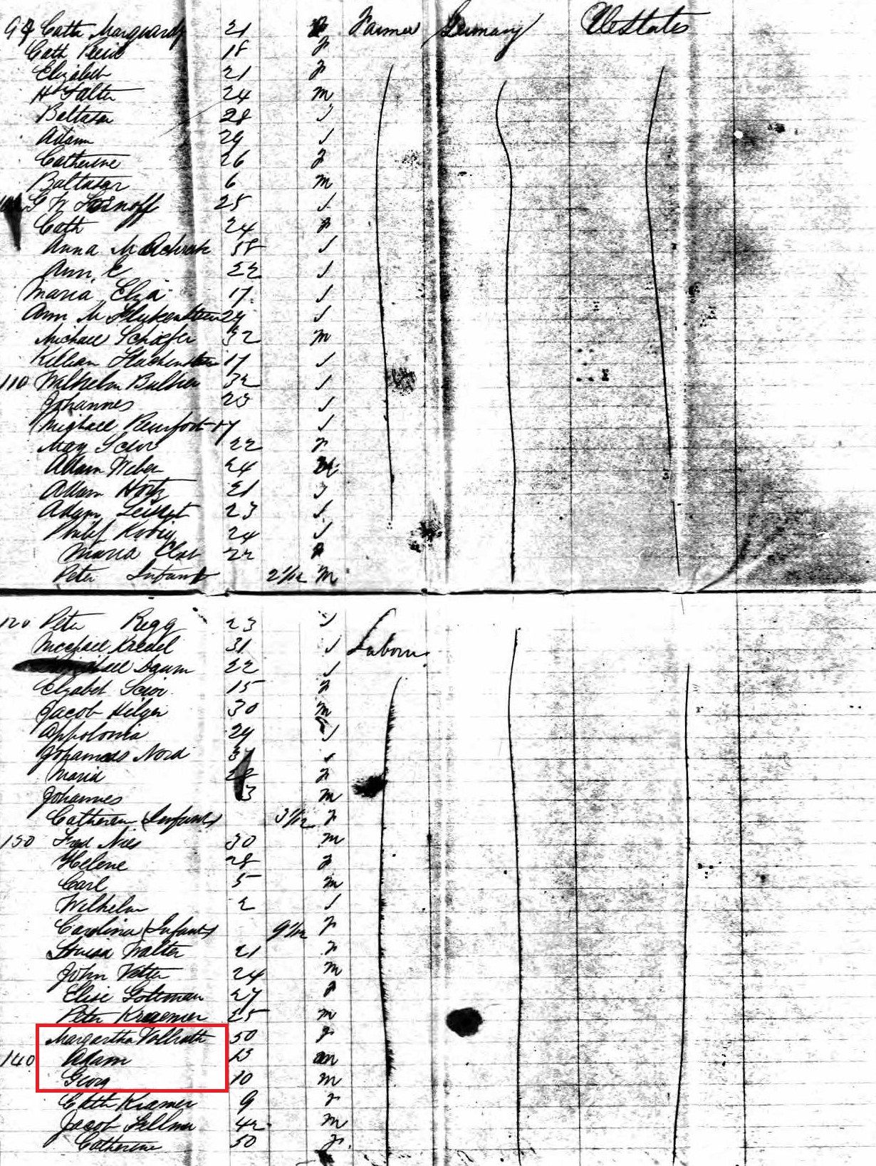
Following names from the New York City Passenger Port Arrivals list:
"22 Feb 1851 aboard the ship Gertrude, from Rotterdam [Holland]:"
"Johan Vollrath - age 48 from Hesse" [father]
"Johan [Porter] Vollrath - age 20 from Hesse" [brother]
- - - - - - - - - - - - - - - - - - - - - - - - - - - - - - - - - - - - - - - - - - - - - - - - - - - - - - - -
"18 Jun 1852" aboard the ship Argo, from Liverpool [Enland]:"
"Margaretha Volrath"- age 50" [mother]
"Adam Volrath" - age 13" [brother]
"Georg Volrath" - age 10" [self]
'Geo. H. Fulrath' was listed in the newspaper, the Carson Nevada Daily Appeal,
on 2 Sep 1865 and 17 Dec 1865. Source: Nevada State Library and Archives.
Nevada Directory 1868-1869
Fulrath, George
Location: Virginia [City], Nevada
Occupation: baggage clerk, Wells, Fargo & Co.
He was briefly married in Nevada:
George H. Fulrath
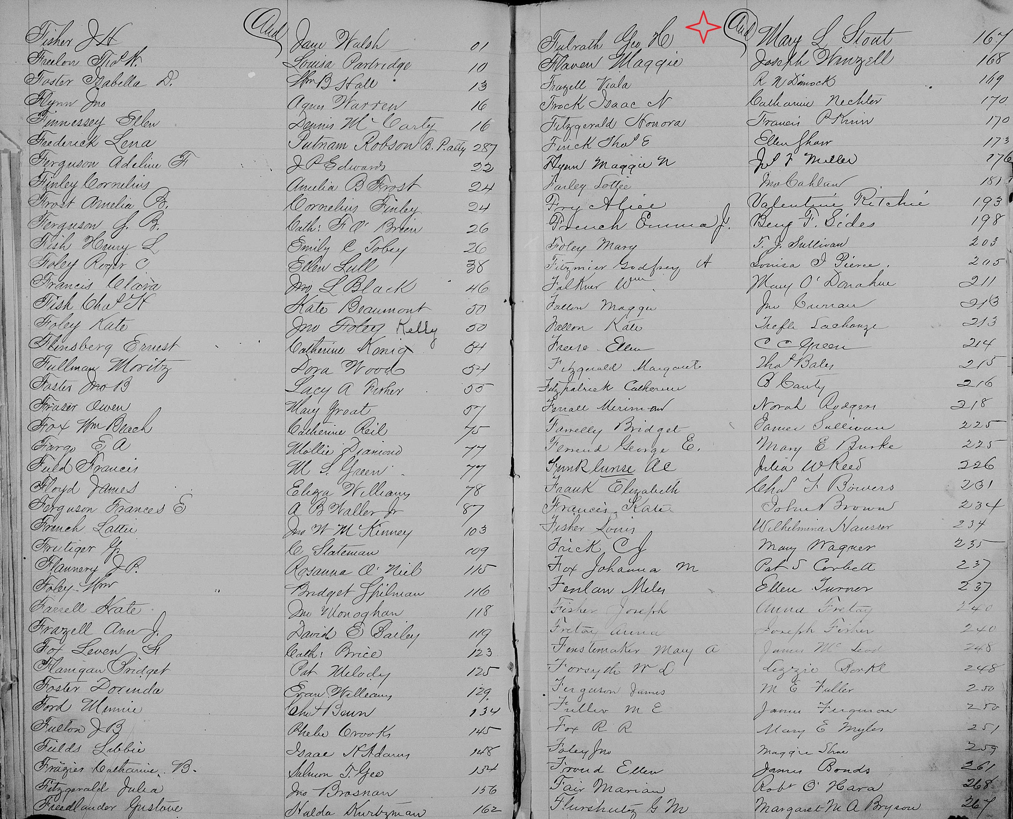
Spouse: Mary L. Stout
transcription error in Western States Marriage Index, 1809-2016, has her last name transcribed incorrectly as "Stint". See attached picture of the Nevada Marriage Register.
Marriage Date: 6 Jul 1869
Marriage Location: Virginia City, Storey Co., Nevada
Source: Marriage Book Index @ Storey Co. Courthouse, indicates marriage license to be found in Volume A, Page 166.
Marriage announcement was in the Sacramento Daily Union, Volume 37, Number 5704, 9 Jul 1869, "In Virginia [City] [Nevada], July 6th, George H. Fulrath to Mary L. Stout."
Whether Mary died, possibly during childbirth, or she and George divorced before George's travels back to Illinois, is unknown. There's only a 21 month time gap between his marriages. There was a Judge Alfred Stout (born Missouri) listed in the 1870 census for Virginia City, Nevada, who may have been Mary Stout's father. Furthering this possibility, said Alfred Stout was also listed in the 1871 Virginia City, Storey County Directory as a "toll road agent", furthering the probability George would have come to know the Stout family through his employ as a stage coach clerk/operator.
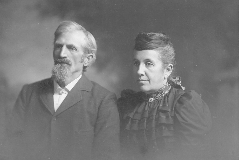
George married Rachel Ann Ervin on 30 Mar 1871, in Carroll County, Illinois.
From Carroll County 1893 Platbook
Fulrath, George Res., Sec. 16 P. O. Mt. Carroll
General Farming. Specialty Short Horn Cattle. Breeder of Draft Horses.
From Prairie Farmers Reliable Directory 1917
Became county resident in 1871.
Fulrath, Mrs. Rachel A. (Irvin) Lewis, Laura, Lillian, Charles, Ida, Anna, Pleasant View Farm Savanna R2 Mt Carroll Sec7 O191a Farmer
GEORGE HENRY FULRATH'S DIARY OF CROSSING THE PLAINS IN 1864
This manuscript was completed the 15th day of November, 1864.
Copied in 1961, by his great grand daughter, Janice Carolyn (Parker) Eller.
Recopied and digitized in 2001 by his 2X great grandson, Mark Hayden.
Preface: My readers, I merely intend to write the particular points on this route, such as rivers, creeks, mountains, lakes and valleys. Also the different tribes of Indians and camping places, etc.
Started for California from Mt. Carroll, Illinois on the nineteenth day of April 1864. Crossed the Mississippi River at Savanna and landed in Sabula, Iowa. Traveled five miles and camped, 19th.
Crossed Deep Creek and arrived at Mill Creek. Camped 20th.
This morning I arrived at Maquoketa, then took the South Road and arrived at Smith Town. Camped 21st.
Crossed Bear River, then arrived at Wyoming. Then Madison, then came to Smith's, and Fulrath stayed here until the 25th.
On Monday Morning I started my journey again. Crossed Bear River and arrived at Anamosa. Crossed Wobsey River and arrived at Fairview, then Springville. Camped 25th.
Arrived at Marion, then came to Cedar Rapids on Cedar River. Crossed the River. Camped 26th.
Came to Iowa River. On this River there is very good timber. Camped 27th.
Crossed the River at Marengo. Traveled over rough country today. Camped 28th.
Arrived at Brooklyn, then Grinnell. Came to Sugar Creek. Camped 29th.
These Indians through this country are the Mishawaka Tribe. Arrived at Newton, then came to a small stream of water. Camped 30th. Camped on the same place the first of May.
This morning I arrived at Skunk River. This River has a very wide bottom and is very miry. Came to Rising Sun, camped 2nd.
Arrived at Fort Des Moines. Crossed Des Moines River. Crossed a creek and camped 3rd.
This morning I arrived at North Coon River, then Adel, a small village. Came to New Devlin, then arrived at Middle Coon River. Camped 4th.
Arrived at South Coon River. Camped on the wide prairie 5th.
Traveled all day on prairie, not in sight of a house. Arrived at Prairie Creek. Camped 6th.
Came to Grove City, then arrived at Turkey Creek. Camped 7th.
Crossed Turkey Creek and arrived at Lewis about ten o'clock. Camped 8th. We stayed at this place until the 12th.
This morning we crossed East Nishnabotna, then at afternoon, West Nishnabotna River. Camped 12th.
Crossed Jordan Creek, then Mesceter Creek, and arrived at Council Bluffs. This is five miles from the Missouri River. Camped in town 13th. Stayed here on the 14th and 15th.
We traveled five miles southeast of town on the Missouri Bottoms. Camped here until 21st. The Carroll County Company arrived in Council Bluffs on 17th. Mr. Rupple and Brady came to us and camped with us. During this time we made preparations for the Abounding Plains. Owing to such a large Emigration at the Bluffs, we crossed at Bellevue, fifteen miles below the Bluffs.
NEBRASKA TERRITORY
Traveled five miles and arrived at Papillion Creek. Camped 21st. Camped the same place on the 22nd.
Traveled all day on prairie. Arrived at a spring. Camped 23rd.
Arrived at Elkhorn City. This is the Council Bluffs and Omaha Route thirty miles from the Missouri River. Crossed Elkhorn River and camped 24th.
Arrived at Freemont, a small town and settlement. Camped 25th.
This morning we struck Platte River for the first time. This is fifty-five miles from Omaha. Here is the old crossing of the Platte River. We take the North Side of the River. Camped 26th.
Now we have reached the Abounding Plains. We find plenty of water and grass and the road is good to travel on. Horses, mules and cattle, men and women all look spry, gay, and flourishing. Now let us try it. Arrived at Shell Creek. Traveled beside the Platte River and camped on the same 27th.
Today we traveled all day beside the Platte and camped on the same 28th.
This morning we arrived at Mr. Dickinson's residence. Camped here the 29th.
Arrived at Columbus. This is situated on the North Branch of the Loup Fork. Ferried across this River. This is the last town we pass until Salt Lake City. One mile west of this town we camped 30th.
These Indians are the Pawnee Tribe. They are peaceable at present. Arrived at Prairie Creek. Now we come to the Lone Tree. The reason that this is called the Lone Tree is because there is no other timber within four hundred miles westward. Camped on the bank of the river 31st.
Traveled all day on the open plains. Camped on the same the first of June.
We find the roads laden with Emigrants on our Route, and we are also in sight of Emigrants for miles on the South Side. Traveled beside the Platte River all day. Camped on the same 2nd.
The level bottoms are about forty-to-fifty miles wide, extending back to the Bluffs in a northerly direction. We still pass a few adobe houses on the road, but they are getting scarcer. Traveled on the wide plains all-day and arrived on the banks of the River. Camped 3rd.
We traveled about one hundred twenty-five miles without crossing any streams of water. We used Platte River water during this time. This morning we arrived at Wood River and traveled on Wood River about 40 miles. Camped 4th.
Arrived at Platte River again. Here we passed the last house on the north side of the North Platte River and arrived opposite Fort Kearney. Camped at a small creek 5th.
This Fort is on the south side of the North Platte. Traveled beside the Platte River. Arrived at a ravine. A very steep descent here is where we first find alkali. This is something similar to soda and is very bad on stock in wet seasons. Being this is a very dry one it is not very dangerous though we must prevent our stock from eating it. We here find plenty of dead stock, caused by eating grass or drinking water wherever this alkali is. Camped on the banks of the River 6th.
Arrived at Elm Creek. Here was a man who shot himself accidentally on the 31st of May 1864. As we ascend to the Rocky Mountains we feel the atmosphere getting cooler. Arrived at Buffalo Creek, then came to Willow Lake. Camped 7th. Camped on the same place the 8th.
In regards to the Platte River, this river is from one to one and a half miles wide. The bed of this river is quicksand. The water is muddy and of a yellowish color, though it is wholesome. This river has a very strong current, from the Rocky Mountains to the mouth, and it is a very bad stream to cross either by ferry or any other way. We find the water some tainted with alkali, though this is all that the Emigrants have for refreshment. No timber on this river whatever, excepting about one hundred miles from the mouth upward. Today we traveled beside the Platte, arrived at Pawnee Swamps and Springs. Here we have the first sand bluffs to cross. This is opposite the junction of the North and South Platte Rivers, altitude two thousand six hundred and eighty five feet. Arrived at Carrion Creek. At this place there was a man killed and one wounded by Indians. They attacked them as they were driving their stock along the road. This was done on the fourth of June. Those Indians are the Sioux, or the Sioux tribe. We now find that we are amongst a savage tribe of Indians and we must be on the lookout constantly. Those Indians are back in the bluffs and not in sight, except on a raid. The Emigration is still in small companies. Camped on Carrion Creek 9th.
In regard to a buffalo hunt and game along the plains, we find the game scarce along the river and the Emigrants dare not go back in the bluffs to hunt on account of the Indians. Mr. Rupple and I ventured to go back in the hills to hunt where the bluffs are closer to the river. We left the train and rode back in the bluffs about ten miles. Here we got in sight of two buffaloes. We came up within twenty-five or thirty rods and they then saw us. We gave chase about five miles, but because we had to watch the red man more than the buffaloes, we did not succeed in getting them. We got in sight of antelopes and coyotes. We struck our way homeward and overhauled our train in the evening at Wide Deep Creek. Camped 10th.
The grass is now getting scarce but the road is still good to travel. Came to Black Mud Creek, North Bluff Fork. Crossed Bluff Creek and arrived at Bluff Springs. Camped 11th.
The land is now soft and swampy about those springs and creeks. The bluffs are now reaching the banks of Platte River at some places. Arrived at Goose Creek. Came to sand bluffs two miles across. At the foot of those bluffs we find a great many springs of cold water. Came to Shoal Creek. These creeks are bad to cross. Arrived at Wolf Creek, camped 12th.
Here we see the first granite, or rocks, on the Platte River. The east foot of the sandy bluffs is a steep ascent. Here we had to double team. Arrived at Watch Creek opposite Ash Hollow. Ash Hollow is where the Emigrants strike the North Platte. Those that crossed the South Platte River arrived at Castle Creek. This is good water to drink. Castle Bluffs is on the south side of the River. Now we arrived at bluff ruins. Camped 13th.
This morning we came to Sandhill Creek, then Crab Creek. We are now in sight of Chimney Rock to the west of us. Camped 14th.
Today we traveled beside Platte River. Good roads all day. Camped 15th. Camped on the same place 16th.
This morning we passed a small lake to the left and arrived at Cobbs Hill. Then we came to Chimney Rock. This is on the south side of the River. It is similar to a tower four hundred feet high. This Chimney looks as though it were about one mile from the south banks of the River, though it is seven miles. We are now getting to where the air is getting more pure, and can see things at a great distance. In regard to bluff ruins, we leave this about one mile to our right. This looks like an old castle or the ruins of a city. Here we had the first rainstorm since we left the State of Iowa. This lasted about six hours, and we had to stake our wagons to the ground to keep them. Somewhere on the plains the hail fell as hen's eggs. This we call one of the Plains Storms.
Now the land begins to be sandy and barren – prickly pears and wild sage during the remainder of the journey. Grass is now getting very scarce and our fuel is green willow and buffalo chips if you please to call it so. This afternoon we crossed three different creeks and arrived at the line between Nebraska Territory and Idaho Territory. Camped 17th.
IDAHO TERRITORY
Arrived at Spring Creek. Here we see Scott's Bluffs on the south side of the River. We still see the Emigrants passing along the Bluffs on the side of the Platte River. Arrived at a high bluff, camped 18th.
By ascending this bluff a view can be gotten of Laramie's Peak in the Black Hills. Came to Rawhide Creek and arrived at Platte River. Camped 19th.
We have now passed a great many Indian camps where we found the Squaws and Papooses at home and Chiefs and Indians are out watching to attack the Emigrants. We have not been troubled any yet but we hear of trouble ahead. Now the Emigrants are joining in larger companies. I think this is a very good idea. This morning we arrived at Fort Laramie. This is on the south side of the River. We stopped here two hours on account of grass being scarce. Here we traveled four miles and camped 20th.
This is five hundred and thirty miles from the Missouri River. Here we find a few small poplar trees and plenty of wood for use. This is encouraging for Emigrants after using buffalo chips for about four hundred miles. We have now arrived at the Black Hills. Crossed a high bluff and left the Platte River about four miles to our left, and arrived at Cottonwood Springs. Camped 21st.
We now find the road very rough and mountainous, and craggy ascents. Here was a man shot by Indians. He was an Indian trader. Another man went out hunting and Indians killed him. Another man kept back of his train about a half mile. Indians attacked him and shot him with an arrow. This was done on the 19th and 20th of this month. I will now explain a little about the Indians. As we travel along we perceive that they are making preparations for some depredation. They tell us that they were going to fight the Pawnee Tribe, but we understand their intention. Instead of them fighting the Pawnees they intend to fight the Emigrants. They always take the advantage of the Emigrants. They are always out of sight except in the evening or morning and sometimes during the night. Arrived at Alder Clump Springs. This is very good, or pure water, though with some alkali springs nearby. This is fifteen miles from the River. A troop of soldiers is camped at this place, guarding the route. Camped 22nd. Camped the same place 23rd.
We now find plenty of wood but not much grass. Arrived at Platte River. Good place to camp 24th.
We this morning traveled eight miles beside Platte River, and arrived at a serious looking place. Here we find a train that was attacked by Indians this morning at sunrise. They had six wagons and twenty-one head of horses. They were camped on the bank of the River and their horses were about a mile from camp with two men on guard. They wounded one of the men, but still he shot one of the Indians. The Indians cut the hobbles and drove off seventeen head of their horses, which they never saw any more. We took them sixty miles to the upper bridge on Platte River. This day we joined a train of about thirty wagons and two hundred head of horses and mules and about fifty men. We were all well armed and we had from six to ten men on guard every night. The Indians are always on the watch and do not trouble big trains. We find that it is dangerous to travel in small trains. Traveled on Platte River and crossed some high bluffs and arrived at the River again. Camped 25th.
We traveled on Platte River about eight miles and arrived at sand bluffs. Here the bluffs strike the River, on both sides. We this afternoon traveled over sandy bluffs. Arrived at the River. Camped 26th.
This morning we arrived at the lower Platte River Bridge. Here is a route, which is called Humboldt Cut Off. This leads to Galton and West Bannock Idaho Territory. Here we cross the River, on account of it's being very sandy on the North Side. We are still in sight of Laramie's Peak, about fifty miles to the South. We traveled nine miles on the south side of the River. We this morning arrived at mineral springs and a lake. This is bad water. Came to a rock avenue and steep descent. The road is rocky and rough. Here we leave the Platte River and arrive at alkali swamps and springs. This water we dare not use. We traveled two miles north and arrived at a good spring. Camped 28th.
In our travels from Fort Kearney to this place we have passed a great many dead head of stock, caused by drinking alkali water or eating grass where alkali is. Now we still find more alkali springs and alkali flats. The wood is still scarce. We use the old fuel and some green wood similar to wild sage. We today traveled on a good road, past alkali flats, and arrived at Sweetwater River. Came to Independence Rock. Camped 29th.
This rock is a solid body. It covers about a half an acre of land, is about four hundred feet high, and is almost covered with inscriptions of different Emigrants. We have seen names of Emigrants written all along on buffalo heads and stones stating when they have passed there, what part of the country they were from, and where they were bound for. Sweetwater River is six rods wide and is about four feet deep. The water is clear, but not wholesome. We traveled up Sweetwater River about ten miles and arrived at Devil's Gap. Camped 30th.
DEVIL'S GAP
This gap is one of the wonderments of the world. It passes about a mile through the rocks. The River gets narrow very rapidly. At the entrance of this Gap it is about twenty-five feet wide. The rocks on each side are about two hundred and fifty feet high and they are perpendicular, or rather on the projection. We are now in sight of snow on the Rocky Mountains. Today we traveled on Sweetwater. Crossed Sage Creek. Camped the first of July.
On this River we find plenty of grass. Arrived at Little Cottonwood Creek, then came to Ice Springs. Arrived at Sweetwater again. Camped 2nd.
We have been ascending the Rocky Mountains for six hundred miles. Here we find very steep ascents. Passed a good spring, then crossed Strawberry Creek. Arrived at a branch of Sweetwater, then came to Willow Creek. Here is Carson Cut-off, or the junction of the California and Oregon Roads. Here part of our company leaves for Oregon. Traveled about ten miles and arrived at a good spring of cold water. Camped 3rd.
Here we arrived at the Great South Pass, or the summit of the dividing ridge of the Rocky Mountains. This is six hundred and twenty nine miles from the Missouri River. We leave Big Horn Mountain to the right and travel three miles. Arrived at Pacific Springs. Here we find the water running in a westward direction and we are on the descent of the Rocky Mountains. For the last week we had very cold nights and ice froze half an inch thick. We are still in sight of snow on either side of us. We find the roads good to travel on. His day we traveled thirty miles across dry Sandy Creek, then came to Little Sandy Creek. Arrived at Big Sandy Creek. Camped 4th.
These Indians are the Snake Tribe. They are slippery rascals. I now will explain how we guard our stock at night. We form a circle with the wagons, and have our stock inside, with guards posted around the corral. This night we had our stock stampeded and they broke through the wagons. There were two guards at the corral and two guards placed about twenty rods from the corral. The outside guard heard the Indians crawling through the brush. They were trying to get between them and the wagons. Our camp was in a great uproar and our stock all gone. Some of our men were so badly scared that they laid in the sagebrush all night. Others gathered up the stock all right and nobody was hurt. This was our Fourth of July celebration. We now hear that the Indians on the Platte River have commenced their depredation, which we expected. We had just passed through that country in time, for they were making great preparations when we came along there. Crossed Big Sandy and traveled on a rough road. Arrived at Green River. Camped 5th. Camped on the same place the 6th.
This River is about thirty rods wide and about three and a half feet deep. The water is clear and runs very swiftly. It is a very dangerous stream to ford. Here a man drowned on the Fourth of July. He went in to bathe. This morning we crossed the River all right. Traveled twelve miles and arrived at Black Fork Creek. Camped 7th.
We find the grass still getting scarcer and our stock looks as if they wanted a little corn. Arrived at Hams Fork Creek, then came to Blacks Fork Creek, again. Crossed Blacks Fork Creek the fourth time. Camped 8th.
Here we cross the line between Idaho Territory and Utah Territory.
UTAH TERRITORY
Here is where the Stage Road comes into this one. This road starts from St. Joe, Missouri, and from Ft. Kearney, Nebraska Territory. It runs on the south side of the Platte River and passes through Denver, Colorado Territory. We cross three streams of cold water. This is the purest water that we have had on our journey thus far. This has no alkali in it. Arrived at Ft. Bridger. Passed the Fort and traveled one mile. Camped 9th.
This Fort is situated in a nice valley. There are a great many creeks running through this valley. Here is a road running Soda Springs to Bannock, Idaho Territory and to Oregon and to California. We take the Salt Lake Route. We today traveled over mountainous country. Here we find the road craggy, and steep ascents and descents. Arrived at Muddy Creek. Camped 10th.
We today traveled over high mountains. Those are the Bear River Mountains. Passed a beautiful spring on the side of a big mountain. Arrived at Bear River. Camped 11th.
Here we find plenty of grass, plenty of wood, and good water. This is a treat to Emigrants. This River is about five rods wide and about two feet deep and runs through ledges of rocks with high mountains on both sides. Those Indians are the Crow Tribe. They are peaceable at present, though in the past they have done a great deal of mischief. We this morning went down a very steep descent and traveled all day in a canyon. Arrived at a big spring of cold water. Camped 12th.
It is fifteen miles through this canyon. It is from five to eight rods wide. The rocks on either side are almost perpendicular and are from one thousand to fifteen hundred feet high. This is a great sight. This morning we arrived at Weber River. Here we find a Mormon settlement. This seems like civilization again. This River is about two and a half rods wife and two and a half feet deep, and runs down hill. Traveled eight miles on this River, past a coal mine to our left. Here we pass a great many springs, beside this mountain. Crossed Weber River and arrived at a small creek. Camped 13th.
We now enter another very deep canyon. This is about five miles long. We find the road graded here. Now as we come out of this canyon we get a fine view of Salt Lake and City, and valleys. Eight miles from here to the city we find the road level and good. We left Fort Douglas to the right of us and arrived at Salt Lake City. Camped at the edge of the city 14th.
I will now explain a little about the city and the surrounding country. This is a fine city, situated on the north side of the valley. There is water running through this city, in every street. Everything looks fine and beautiful, all sorts of shrubbery and trees. This City is about fifteen miles from the Lake. This valley is surrounded by mountains. This is beautiful farming land but it must be irrigated. This valley is about twenty-three miles wide and is about sixty miles long, extending from Salt Lake to Utah Lake. This valley is settled by Mormons. Their crops look fine and they are just harvesting. A great many of the Emigration stopped in this country. In regards to the Lake, this water is very salty and cannot be used. Three buckets full of this water makes one bucket full of salt. The shores of the Lake are covered with pure salt. Fish cannot live in this water. In the middle of this Lake is a long island, called Church Island. This Island belongs to Brigham Young. On this island he keeps the City stock. This island is thirty miles wide and sixty miles long. I will now explain a little about Mormonism. In the first place I will state how many wives Brigham Young has. At the present time he has sixty three hundred and sixty five children under ten years old. He dare not slap a child on the street for fear of slapping one of his. Camped in the City on 15th.
There is a route from this city to California, which is called the Humboldt Route. We take the Stage or Telegraph Road. We now travel in a south direction across a great many streams of water and arrive at Jordan River. Camped 16th.
This River is about three rods wide and about two and a half feet deep. The water is considerably salty. This River runs from Utah Lake to Salt Lake. We this morning cross the River, travel eight miles, then across a high mountain to our right. We leave Utah Lake about six miles to the left. We are in sight of a Mormon settlement called Dixie on the east side of Utah Lake. Traveled on level ground this afternoon and arrived at Camp Floyd. Camped at a big spring 17th.
Here we had to take our stock about three miles to grass. This Fort was built in the Mormon trouble, now it is almost all fallen down. We today crossed a mountain and came into a nice valley. This valley is destitute of grass. Arrived at a Mail Station. Here we find plenty of water but no grass. Camped 18th.
We had to take our stock about four miles to grass. Today on a level road thirty miles without water. Arrived at Government Springs. Here is no grass excepting wild rye. Camped 19th.
Crossed a mountain three miles high and traveled about six miles on a descent. Arrived at Indian Springs. The water is not tainted with alkali or any minerals. Camped 20th.
This is the last spring on the east side of the desert. Here the Emigrants must take a supply of water to last them across the desert. We also had to cut mountain bunch grass with our knives to last across the desert. This evening at six o'clock we started our journey across the desert. On the twenty-first traveled seven miles and arrived at barren desert. We find the road good to travel on. The dust in the road is about six inches deep though it is very calm and does not bother any, which makes it pleasant traveling. Traveled till twelve o'clock and arrived at a mountain. This we must cross. This mountain is a mile high and considered to be in the middle of the desert. Crossed the mountain and arrived at alkali flats. We leave a mountain to our left and alkali swamps to our right. Now we traveled five miles northward and arrived at Fish Springs at eight o'clock in the morning. This is forty miles from Indian Springs on the east side of the desert. Here we find plenty of water but dare not use it. This is salt water here. We do not find any grass. Traveled on good roads all-day and arrived at Willow Springs. Camped 22nd. In a night and a day we have traveled seventy-five miles without unharnessing our horses. Camped on the same place 23rd.
Here we find plenty grass and water. Those springs are like wells and we have never found any bottom to them. His desert is entirely different from what I expected. We found the road very crooked, winding round the foot of mountains. Here we suffered for water but we got across all right with our stock. Those Indians are the Goshute Tribe. We find those Indians peaceable at present. This tribe is entirely different from any that we have seen yet. They are a filthy, dirty, ragged and weakly tribe. This day we traveled over mountainous country and came to Duck Creek valley. Traveled up this valley four miles and arrived at Duck Creek. Camped 24th.
This valley is not settled yet. A few families have stopped in this valley and commenced opening farms. I think that this valley will soon settle up. His valley is about four miles wide and about fifteen miles long with plenty of water to irrigate. We find, as we cross the mountains, some small pine and cedar trees. Most of the valleys are destitute of any growth whatever excepting wild sagebrush. Camped in this valley on the 25th.
This afternoon we traveled eight miles up Duck Creek valley past a mule station and crossed Duck Creek. Camped 26th.
We this morning crossed a desert valley twenty-five miles across. Arrived at a spring. This water is salty – here we must use same for our stock. Traveled all afternoon on a gradual ascent and arrived at Antelope Springs at six o'clock. There we find good water but no grass in the country here. We stopped about two hours and fed our stock on sagebrush. This evening at eight o'clock we started across a mountain and then traveled on a desert about twelve miles and arrived at Spring Valley. Camped 27th.
Here we find plenty grass and water. In this valley is a government station. They are here to protect the Emigrants camped in this valley. Camped 28th.
We this morning traveled down this valley in a southward direction. We left the valley to our right and crossed a mountain to our left. Traveled five miles through a canyon. Arrived at a desert valley twenty miles across. We do not find any water in this valley. Here we cross the Utah Territory and Nevada Territory line.
NEVADA TERRITORY
We this evening arrived at a high mountain. We left the road and turned about a mile and a half to our left. Arrived at a good spring. This is on the side of a mountain. Here we find plenty of bunch grass. Camped 29th.
This bunch grass is very good for stock. There is a great deal of substance in it. It only grows on the mountains. Here is plenty of wild rye in this country but stock don't like it. It grows something like the common rye. This morning we traveled about four miles and arrived at Egan Canyon. Here is the first gold and silver mine. This has been discovered only a short time ago, and is settling up very fast. We find this canyon about two and a half miles long, and very steep mountains on each side. Traveled across a very rough, mountainous country and crossed a small stream of good water. We then arrived at Mountain Spring. This is on the summit of this mountain. Here we find good water but not much grass. Camped 30th.
From here to Ruby Valley it is called "forty miles without water or grass", and the road is mountainous. Here we take water along with us. Traveled on a descent about ten miles, then we got into a desert valley. Crossed an alkali flat and came to a mail station, but no water. Water was hauled to this station by the Overland Stage Company for their own stock. Traveled on an ascent, up a mountain again. Crossed the summit of this mountain. Here we got a nice view of Ruby Valley. Traveled three miles and arrived at Ruby Valley. This is about nine miles from grass yet, and at seven o'clock in the evening we find the road good to travel on. Passed Ruby Valley Station on the right and Fort Ruby to our left. Here we left the road and traveled about eleven miles down the valley. This morning at four o'clock we got into camp beside a good spring. Camped the 31st and the first of August.
As we have traveled a great deal without grass and water, or the water we did have was salt or alkali and some kind of mineral water, during our journey we found but very few springs of pure water. Here we find that our horses and stock must be refreshed and rested. We find plenty of grass and good water here, also plenty of wood on the side mountain. This tribe of Indians is what they call the Shoshone. There is not much difference between this tribe and Goshutes. They are all a miserable set. The weather is beautiful and warm though we are still in sight of snow, six miles to the summit of this mountain. There the mountain is covered with snow, and in fact, the snow is cold in the summer. In regard to this valley: this valley is not settled up yet, but I think will soon be. There are a few families stopped in this valley. This spring they have commenced opening farms. This valley extends to Humboldt River, running in a north and south direction. It is about fifty miles long, and about from nine to fifteen miles wide. Fort Ruby is situated on the southwest corner of this valley. This Fort is beautifully located. On the south end of this valley is a mail station and store, also a Post Office. I think in time this will make as fine a town as there is in the Territory. The most of this valley there are a great many springs running out of the mountains. This water is pure and cold. In this valley we find acres of wild clover. This is considered to be as good as our tame clover in the States. Thirty miles down this valley is a hot spring. This water is hot enough to boil a turkey if we had one. AS we have now arrived in a country where the Indians are more peaceable, we fell ourselves safe to venture out on a hunt. This is the tenth of August.
Mr. Shearer, Hasbrook, Pearce, and I started down the valley along a range of mountains. Every few rods we found a beautiful spring running into the valley. There we arrived at a beautiful stream of water, which is running down the mountain. Here a great many Indians are camped. Here we leave our horses and wagon. Now we shoulder our arms and strike into the mountains. We hunted all the afternoon, returned to our Indian camp again, and did not succeed in killing anything. Here we camped with the Indians all night.
They treated us well. The way those Indians live in camp: they gather wild rye and wild weed seeds and pound them up together in a stone mortar. Then they make soap or mush out of it. The squaws must gather this seed. They have the papooses tied to a board on their backs, and here they go. On the eleventh we took another scout through the hills. Here we were disappointed in finding game. We expected to find some elk, antelope, deer or bear, but we did not see any of them. We find plenty of jackrabbits in the sagebrush. These rabbits are about as big as the English Hare. One of these rabbits will make a dinner for six men. Now we returned to camp again, hitched up our horses, and started for home. Passed a milk ranch. Here we bought a bucket full of milk. This is the first milk we had for some time, and we had a great feast. All this had amounted to is a few jackrabbits and a bucket full of milk. About this hot springs: there are a great many cold springs of water running into the valley, which form a beautiful lake. This lake has no outlet except under ground.
The Mount Carroll Company arrived here on the thirteenth of this month. They appear to be in good spirits yet. They stopped here one day and then started their journey westward again. I will now make a statement in regards to Indian depredations on the North and South Platte River, which we now hear by telegraph from Salt Lake City and also Emigrants. The general outbreak commenced on the tenth of August, One thousand, eight hundred, and sixty-four. On the south side of Platte River they commenced near Denver City and went towards Fort Laramie, cut the telegraph down, and burned and destroyed mail stations. Also attacked a great many Emigrants, killed a great many, and drove off their stock. On the North side of Platte River they commenced about Carrion Creek (this you will find previously written). From there they attacked all Emigrants, killed a great many men and took women and children prisoners. Some of the women escaped and children were stuck up on poles and left there to die. The Emigrants that escaped and arrived here state the following: as they came by Cottonwood Springs they found whole trains of wagons. Their stock was all gone and whole families massacred. From there through the Black Hills they have murdered and slain everything that came in their way. Also the bridge on the Platte River. They burnt the bridge and drove the soldiers out of this station and burnt it. Between Platte River and Alkali Swamps, all along this part of the route there were a great many bodies found in the sagebrush. Some of them had as high as nine arrows in their bodies. They found as high as seven and eight bodies in a place. They have also committed depredations on the Idaho Road. We were about the middle of the Emigration this year. The Emigration that was east of this trouble, which was estimated at five hundred wagons, turned back. As we traveled through that part we heard of a great deal of trouble behind us. It appears that we were ahead of the trouble all the time. It is preposterous and perverse and superstitious to let such a nation live.
We today started our journey again. Traveled up this valley past Fort Ruby and came in the old road again. Crossed a mountain to our right, and arrived at a warm spring. This spring is on the east side of a desert valley. Camped at this warm spring 16th.
Today we traveled across this valley. We found it twenty-five miles wide, no water nor grass on it. Passed a mail station, which was burned by Indians on the 9th of this month. We arrived at a mountain and saw a canyon turning to the right. We left the road and traveled four miles in this canon. Arrived at a good spring and a little mountain bunch grass. Camped 17th. Camped on the same place 18th.
This morning we crossed over rough road. Arrived at Smoky Valley. In this valley is a salt factory. Traveled across this valley and came into a canyon. Here we find plenty of water. Camped 19th.
Today we traveled on a good road, went through a canyon, arrived at a good salt spring and no grass excepting some wild rye. Camped 20th.
Traveled eight miles and arrived at the junction of the Austin and the Stage Road. I will here state that Mr. Brady and Rupple were with us during our journey. Here at this junction we part. They are going to, or through Austin while we take another course. We now traveled about three miles and arrived at the Mount Carroll Company. They were camped beside the road. They are still bound for California. We stopped about an hour here, then took a farewell to all and started our journey onward again. Traveled six miles and then left the Stage Road and turned to the right. Left Reese River to our left and a range of mountains on our right. Passed Amadore and crossed Silver Creek and traveled into the mountains and arrived at a good stream of water. Camped 21st.
At this place we find plenty of good grass and plenty of wood, and this water is pure. Now, as we hear that the grass in California is all dried up, we thought that we would stop and recruit our stock here. We built a corral out of knotty pine boughs and corralled our stock nights and watched them day times. Here they gained finely. All of our stock amounts to one hundred head. It is one hundred eighty miles from Ruby Valley to this place and from there to here we found the grass very scarce, or hardly any. We don't expect hardly any for the next two hundred miles. We stayed here till the twenty-first of September.
There were a good many Emigrants stopped here in the mountains to recruit their stock during the time that we stayed here. We enjoyed ourselves very well in this range of mountains. There are a great many gold and silver mines extending to Humboldt River. Here we were prospecting or trying to find our fortune, but we find that we don't know much about hunting gold or silver. This must be learned, like everything else, however we find some good ledges of quartz. We now find that our stock has improved greatly, and we think that they are able for their journey. They look well and feel fine. We this afternoon started on our journey again and traveled ten miles, arrived at Silver Creek. Camped 21st.
This morning we traveled and passed Amadore to our left and Jacobs Hill to our right. We cross the Stage Road and take the Reese River and Ione Road. The reason that we take this route is that we hear there is no grass on the Stage Route. About noon we arrived at Austin. Here we stopped about an hour or so, and fed our horses. I will now explain this town. This is a mining town in which there are about three thousand inhabitants, and it is one year and a half old. This town is built in a canyon and has very high mountains on both sides. It is quite a flourishing place, containing six quartz mills. Here they have the richest silver mines in the Nevada Territory and are considered to be the richest on the Globe. Those are all quartz mines. Some of the quartz turns out five hundred dollars to the ton. One of those mills, which is called the Oregon Mill, turned out eighty thousand dollars in the month of August. We now travel in a southward direction past Canyon City to our left. Crossed Deep Creek and arrived at Alkali Springs. This is not good water and there is no grass here. Camped 22nd.
This morning we arrived at Reese River and crossed past Washington to our left. Traveled eight miles and arrived at Reese River again and camped 23rd.
This River is about four rods wide and is about one hundred and seventy five miles long. This is a very peculiar River. It runs for miles on top of the ground and then sinks and rises again and etc. It forms a valley extending to Humboldt River and there is a great deal of alkali in this valley, which spoils it for cultivation. We now leave the River and valley and turn to the west. We cross over a mountain and arrive at Ione. This is a salt mining town. At this place they have very rich gold and silver mines. We now crossed a desert valley and traveled on a gradual ascent and arrived at Mammoth. This is another mining town. Traveled about two miles to the summit of this mountain and camped 24th.
We this morning traveled down a very steep canyon. Here we find the road graded. This is a toll road. We this evening arrived at a well. Here there is no grass and we watered our stock till three o'clock in the morning. This is the 25th.
We now start our journey again and travel on very heavy sand all day. This is Alkali Desert. I consider this worse than the American Desert. We are now beside an alkali flat. At a distance this flat looks like the surface of water. There is nothing but an alkali crust on the barren land. Arrived at a well again. Here we watered our stock and then passed a white mountain to our left. Camped 26th.
Here we find some bunch grass. This morning we had to take our stock five miles to water. We this morning traveled on rough road. We passed different wagons that the Emigrants had left. We this day traveled till twelve o'clock at night and arrived at Walker Lake. Camped 27th.
This is on the Indian Reservation. The Government gave them a piece of land on this Walker River. Those are the Payute Tribe. They are peaceable and very gentlemanly Indians. This Walker River starts in the Sierra Nevada Mountains and here it forms a Lake. This Lake is about fifteen miles long and from five to eight miles wide. This is the sink of Walker River. In this River and Lake there are beautiful fish both red and white, Speckled Trout. Camped on the same place 28th.
There is a road from here to Virginia City by Fort Churchill. We take the Wellington Ranch Road or what is called the Big Tree Route. We crossed this River and traveled five miles on the west side of Walker Lake. Now we leave the Lake and turn to the west. Crossed a mountain and arrived at a beautiful spring of water. Here we pass Bald Mountain this night and arrived at East Walker River, at eleven o'clock. Camped 29th.
At this place there is five hundred head of Spanish Cattle. Those cattle were driven from California. They were driven here to winter owing to the drought in California. We traveled up this River about eight miles, then crossed the River and traveled over mountainous country. Those mountains are barren, and of all colors. Arrived at West Walker River again. Camped 30th.
Here we find Emigrants recruiting their stock. We this morning traveled up this River and found both sides settled up. This is now beginning to look like civilization. We now arrived at Wellington Ranch. Here is a store and a start for a town. Here we strike the Aurora and Carson City Road. Traveled about five miles through a canyon. Here the River runs down very rapidly. Here we cross the line between Nevada and California. Traveled three miles and arrived at Walker River again. Camped the first of October.
Here we find plenty of grass and pure water. Here the River forms a beautiful valley, which is all settled up. This is on the east side of the Sierra Nevada Mountains. We are in sight of snow on those mountains. As there is no grass or feed in California and we are informed that business is rather dull there, we thought it would be more profitable for us to stay on this side of the mountains. We stayed at this place until the fourth.
We now leave our company, or the train in which we traveled across the Plains. This train intends to stay here all winter, to keep their stock alive. Plenty of stock companies come across the mountains to feed their stock over here. I will state more about this after awhile. We now travel in a north direction. Traveled five miles and crossed the line between California and Nevada.
STATE OF NEVADA
We now travel on good roads and arrived at the junction of the road that goes by the Big Tree to Stockton, California. We take the Carson City Road. Traveled down a canyon on a graded road past Copper Mountains to our right and Chalk Mountains to our left. Those Chalk Mountains are along the Sierra Nevada Mountains. Those Chalk Mountains look as white as snow and they are very high. Traveled down a very steep descent and arrived at Carson Valley. Traveled about five miles and camped at a tavern 4th.
In regards to this Valley, we find this a beautiful Valley surrounded by a low range of mountains to the east, north, and south and to the west of the Sierra Nevada Mountains. Carson River is running through the middle of this Valley in a northeast and a southwest direction. This is a fine little town. We this morning traveled in this Valley and crossed Carson River. This River is four rods wide and two feet deep, and the water looks very clear. We now rise on a gradual ascent, cross a few, low hills, and then travel on a descent for about four miles and arrive at Eagle Valley. Then we came to Carson City. Stopped at a feed yard the fifth of October 1864.
Now we have arrived at the End of Our Journey.
Biography compilation by great great great grand son Mark Hayden.
Source: Carroll County, Illinois, directory (1878).
*1849 is an error. 1852 is the correct year.
"During the winter of 1851, John Fulrath [George's father] emigrated to America, locating in Pennsylvania. The remainder of the family following him the next year."
Source: History of Carroll County, Illinois, page 792.
Following names from the New York City Passenger Port Arrivals list:
"22 Feb 1851 aboard the ship Gertrude, from Rotterdam [Holland]:"
"Johan Vollrath - age 48 from Hesse" [father]
"Johan [Porter] Vollrath - age 20 from Hesse" [brother]
- - - - - - - - - - - - - - - - - - - - - - - - - - - - - - - - - - - - - - - - - - - - - - - - - - - - - - - -
"18 Jun 1852" aboard the ship Argo, from Liverpool [Enland]:"
"Margaretha Volrath"- age 50" [mother]
"Adam Volrath" - age 13" [brother]
"Georg Volrath" - age 10" [self]
'Geo. H. Fulrath' was listed in the newspaper, the Carson Nevada Daily Appeal,
on 2 Sep 1865 and 17 Dec 1865. Source: Nevada State Library and Archives.
Nevada Directory 1868-1869
Fulrath, George
Location: Virginia [City], Nevada
Occupation: baggage clerk, Wells, Fargo & Co.
He was briefly married in Nevada:
George H. Fulrath
Spouse: Mary L. Stout
transcription error in Western States Marriage Index, 1809-2016, has her last name transcribed incorrectly as "Stint". See attached picture of the Nevada Marriage Register.
Marriage Date: 6 Jul 1869
Marriage Location: Virginia City, Storey Co., Nevada
Source: Marriage Book Index @ Storey Co. Courthouse, indicates marriage license to be found in Volume A, Page 166.
Marriage announcement was in the Sacramento Daily Union, Volume 37, Number 5704, 9 Jul 1869, "In Virginia [City] [Nevada], July 6th, George H. Fulrath to Mary L. Stout."
Whether Mary died, possibly during childbirth, or she and George divorced before George's travels back to Illinois, is unknown. There's only a 21 month time gap between his marriages. There was a Judge Alfred Stout (born Missouri) listed in the 1870 census for Virginia City, Nevada, who may have been Mary Stout's father. Furthering this possibility, said Alfred Stout was also listed in the 1871 Virginia City, Storey County Directory as a "toll road agent", furthering the probability George would have come to know the Stout family through his employ as a stage coach clerk/operator.
George married Rachel Ann Ervin on 30 Mar 1871, in Carroll County, Illinois.
From Carroll County 1893 Platbook
Fulrath, George Res., Sec. 16 P. O. Mt. Carroll
General Farming. Specialty Short Horn Cattle. Breeder of Draft Horses.
From Prairie Farmers Reliable Directory 1917
Became county resident in 1871.
Fulrath, Mrs. Rachel A. (Irvin) Lewis, Laura, Lillian, Charles, Ida, Anna, Pleasant View Farm Savanna R2 Mt Carroll Sec7 O191a Farmer
GEORGE HENRY FULRATH'S DIARY OF CROSSING THE PLAINS IN 1864
This manuscript was completed the 15th day of November, 1864.
Copied in 1961, by his great grand daughter, Janice Carolyn (Parker) Eller.
Recopied and digitized in 2001 by his 2X great grandson, Mark Hayden.
Preface: My readers, I merely intend to write the particular points on this route, such as rivers, creeks, mountains, lakes and valleys. Also the different tribes of Indians and camping places, etc.
Started for California from Mt. Carroll, Illinois on the nineteenth day of April 1864. Crossed the Mississippi River at Savanna and landed in Sabula, Iowa. Traveled five miles and camped, 19th.
Crossed Deep Creek and arrived at Mill Creek. Camped 20th.
This morning I arrived at Maquoketa, then took the South Road and arrived at Smith Town. Camped 21st.
Crossed Bear River, then arrived at Wyoming. Then Madison, then came to Smith's, and Fulrath stayed here until the 25th.
On Monday Morning I started my journey again. Crossed Bear River and arrived at Anamosa. Crossed Wobsey River and arrived at Fairview, then Springville. Camped 25th.
Arrived at Marion, then came to Cedar Rapids on Cedar River. Crossed the River. Camped 26th.
Came to Iowa River. On this River there is very good timber. Camped 27th.
Crossed the River at Marengo. Traveled over rough country today. Camped 28th.
Arrived at Brooklyn, then Grinnell. Came to Sugar Creek. Camped 29th.
These Indians through this country are the Mishawaka Tribe. Arrived at Newton, then came to a small stream of water. Camped 30th. Camped on the same place the first of May.
This morning I arrived at Skunk River. This River has a very wide bottom and is very miry. Came to Rising Sun, camped 2nd.
Arrived at Fort Des Moines. Crossed Des Moines River. Crossed a creek and camped 3rd.
This morning I arrived at North Coon River, then Adel, a small village. Came to New Devlin, then arrived at Middle Coon River. Camped 4th.
Arrived at South Coon River. Camped on the wide prairie 5th.
Traveled all day on prairie, not in sight of a house. Arrived at Prairie Creek. Camped 6th.
Came to Grove City, then arrived at Turkey Creek. Camped 7th.
Crossed Turkey Creek and arrived at Lewis about ten o'clock. Camped 8th. We stayed at this place until the 12th.
This morning we crossed East Nishnabotna, then at afternoon, West Nishnabotna River. Camped 12th.
Crossed Jordan Creek, then Mesceter Creek, and arrived at Council Bluffs. This is five miles from the Missouri River. Camped in town 13th. Stayed here on the 14th and 15th.
We traveled five miles southeast of town on the Missouri Bottoms. Camped here until 21st. The Carroll County Company arrived in Council Bluffs on 17th. Mr. Rupple and Brady came to us and camped with us. During this time we made preparations for the Abounding Plains. Owing to such a large Emigration at the Bluffs, we crossed at Bellevue, fifteen miles below the Bluffs.
NEBRASKA TERRITORY
Traveled five miles and arrived at Papillion Creek. Camped 21st. Camped the same place on the 22nd.
Traveled all day on prairie. Arrived at a spring. Camped 23rd.
Arrived at Elkhorn City. This is the Council Bluffs and Omaha Route thirty miles from the Missouri River. Crossed Elkhorn River and camped 24th.
Arrived at Freemont, a small town and settlement. Camped 25th.
This morning we struck Platte River for the first time. This is fifty-five miles from Omaha. Here is the old crossing of the Platte River. We take the North Side of the River. Camped 26th.
Now we have reached the Abounding Plains. We find plenty of water and grass and the road is good to travel on. Horses, mules and cattle, men and women all look spry, gay, and flourishing. Now let us try it. Arrived at Shell Creek. Traveled beside the Platte River and camped on the same 27th.
Today we traveled all day beside the Platte and camped on the same 28th.
This morning we arrived at Mr. Dickinson's residence. Camped here the 29th.
Arrived at Columbus. This is situated on the North Branch of the Loup Fork. Ferried across this River. This is the last town we pass until Salt Lake City. One mile west of this town we camped 30th.
These Indians are the Pawnee Tribe. They are peaceable at present. Arrived at Prairie Creek. Now we come to the Lone Tree. The reason that this is called the Lone Tree is because there is no other timber within four hundred miles westward. Camped on the bank of the river 31st.
Traveled all day on the open plains. Camped on the same the first of June.
We find the roads laden with Emigrants on our Route, and we are also in sight of Emigrants for miles on the South Side. Traveled beside the Platte River all day. Camped on the same 2nd.
The level bottoms are about forty-to-fifty miles wide, extending back to the Bluffs in a northerly direction. We still pass a few adobe houses on the road, but they are getting scarcer. Traveled on the wide plains all-day and arrived on the banks of the River. Camped 3rd.
We traveled about one hundred twenty-five miles without crossing any streams of water. We used Platte River water during this time. This morning we arrived at Wood River and traveled on Wood River about 40 miles. Camped 4th.
Arrived at Platte River again. Here we passed the last house on the north side of the North Platte River and arrived opposite Fort Kearney. Camped at a small creek 5th.
This Fort is on the south side of the North Platte. Traveled beside the Platte River. Arrived at a ravine. A very steep descent here is where we first find alkali. This is something similar to soda and is very bad on stock in wet seasons. Being this is a very dry one it is not very dangerous though we must prevent our stock from eating it. We here find plenty of dead stock, caused by eating grass or drinking water wherever this alkali is. Camped on the banks of the River 6th.
Arrived at Elm Creek. Here was a man who shot himself accidentally on the 31st of May 1864. As we ascend to the Rocky Mountains we feel the atmosphere getting cooler. Arrived at Buffalo Creek, then came to Willow Lake. Camped 7th. Camped on the same place the 8th.
In regards to the Platte River, this river is from one to one and a half miles wide. The bed of this river is quicksand. The water is muddy and of a yellowish color, though it is wholesome. This river has a very strong current, from the Rocky Mountains to the mouth, and it is a very bad stream to cross either by ferry or any other way. We find the water some tainted with alkali, though this is all that the Emigrants have for refreshment. No timber on this river whatever, excepting about one hundred miles from the mouth upward. Today we traveled beside the Platte, arrived at Pawnee Swamps and Springs. Here we have the first sand bluffs to cross. This is opposite the junction of the North and South Platte Rivers, altitude two thousand six hundred and eighty five feet. Arrived at Carrion Creek. At this place there was a man killed and one wounded by Indians. They attacked them as they were driving their stock along the road. This was done on the fourth of June. Those Indians are the Sioux, or the Sioux tribe. We now find that we are amongst a savage tribe of Indians and we must be on the lookout constantly. Those Indians are back in the bluffs and not in sight, except on a raid. The Emigration is still in small companies. Camped on Carrion Creek 9th.
In regard to a buffalo hunt and game along the plains, we find the game scarce along the river and the Emigrants dare not go back in the bluffs to hunt on account of the Indians. Mr. Rupple and I ventured to go back in the hills to hunt where the bluffs are closer to the river. We left the train and rode back in the bluffs about ten miles. Here we got in sight of two buffaloes. We came up within twenty-five or thirty rods and they then saw us. We gave chase about five miles, but because we had to watch the red man more than the buffaloes, we did not succeed in getting them. We got in sight of antelopes and coyotes. We struck our way homeward and overhauled our train in the evening at Wide Deep Creek. Camped 10th.
The grass is now getting scarce but the road is still good to travel. Came to Black Mud Creek, North Bluff Fork. Crossed Bluff Creek and arrived at Bluff Springs. Camped 11th.
The land is now soft and swampy about those springs and creeks. The bluffs are now reaching the banks of Platte River at some places. Arrived at Goose Creek. Came to sand bluffs two miles across. At the foot of those bluffs we find a great many springs of cold water. Came to Shoal Creek. These creeks are bad to cross. Arrived at Wolf Creek, camped 12th.
Here we see the first granite, or rocks, on the Platte River. The east foot of the sandy bluffs is a steep ascent. Here we had to double team. Arrived at Watch Creek opposite Ash Hollow. Ash Hollow is where the Emigrants strike the North Platte. Those that crossed the South Platte River arrived at Castle Creek. This is good water to drink. Castle Bluffs is on the south side of the River. Now we arrived at bluff ruins. Camped 13th.
This morning we came to Sandhill Creek, then Crab Creek. We are now in sight of Chimney Rock to the west of us. Camped 14th.
Today we traveled beside Platte River. Good roads all day. Camped 15th. Camped on the same place 16th.
This morning we passed a small lake to the left and arrived at Cobbs Hill. Then we came to Chimney Rock. This is on the south side of the River. It is similar to a tower four hundred feet high. This Chimney looks as though it were about one mile from the south banks of the River, though it is seven miles. We are now getting to where the air is getting more pure, and can see things at a great distance. In regard to bluff ruins, we leave this about one mile to our right. This looks like an old castle or the ruins of a city. Here we had the first rainstorm since we left the State of Iowa. This lasted about six hours, and we had to stake our wagons to the ground to keep them. Somewhere on the plains the hail fell as hen's eggs. This we call one of the Plains Storms.
Now the land begins to be sandy and barren – prickly pears and wild sage during the remainder of the journey. Grass is now getting very scarce and our fuel is green willow and buffalo chips if you please to call it so. This afternoon we crossed three different creeks and arrived at the line between Nebraska Territory and Idaho Territory. Camped 17th.
IDAHO TERRITORY
Arrived at Spring Creek. Here we see Scott's Bluffs on the south side of the River. We still see the Emigrants passing along the Bluffs on the side of the Platte River. Arrived at a high bluff, camped 18th.
By ascending this bluff a view can be gotten of Laramie's Peak in the Black Hills. Came to Rawhide Creek and arrived at Platte River. Camped 19th.
We have now passed a great many Indian camps where we found the Squaws and Papooses at home and Chiefs and Indians are out watching to attack the Emigrants. We have not been troubled any yet but we hear of trouble ahead. Now the Emigrants are joining in larger companies. I think this is a very good idea. This morning we arrived at Fort Laramie. This is on the south side of the River. We stopped here two hours on account of grass being scarce. Here we traveled four miles and camped 20th.
This is five hundred and thirty miles from the Missouri River. Here we find a few small poplar trees and plenty of wood for use. This is encouraging for Emigrants after using buffalo chips for about four hundred miles. We have now arrived at the Black Hills. Crossed a high bluff and left the Platte River about four miles to our left, and arrived at Cottonwood Springs. Camped 21st.
We now find the road very rough and mountainous, and craggy ascents. Here was a man shot by Indians. He was an Indian trader. Another man went out hunting and Indians killed him. Another man kept back of his train about a half mile. Indians attacked him and shot him with an arrow. This was done on the 19th and 20th of this month. I will now explain a little about the Indians. As we travel along we perceive that they are making preparations for some depredation. They tell us that they were going to fight the Pawnee Tribe, but we understand their intention. Instead of them fighting the Pawnees they intend to fight the Emigrants. They always take the advantage of the Emigrants. They are always out of sight except in the evening or morning and sometimes during the night. Arrived at Alder Clump Springs. This is very good, or pure water, though with some alkali springs nearby. This is fifteen miles from the River. A troop of soldiers is camped at this place, guarding the route. Camped 22nd. Camped the same place 23rd.
We now find plenty of wood but not much grass. Arrived at Platte River. Good place to camp 24th.
We this morning traveled eight miles beside Platte River, and arrived at a serious looking place. Here we find a train that was attacked by Indians this morning at sunrise. They had six wagons and twenty-one head of horses. They were camped on the bank of the River and their horses were about a mile from camp with two men on guard. They wounded one of the men, but still he shot one of the Indians. The Indians cut the hobbles and drove off seventeen head of their horses, which they never saw any more. We took them sixty miles to the upper bridge on Platte River. This day we joined a train of about thirty wagons and two hundred head of horses and mules and about fifty men. We were all well armed and we had from six to ten men on guard every night. The Indians are always on the watch and do not trouble big trains. We find that it is dangerous to travel in small trains. Traveled on Platte River and crossed some high bluffs and arrived at the River again. Camped 25th.
We traveled on Platte River about eight miles and arrived at sand bluffs. Here the bluffs strike the River, on both sides. We this afternoon traveled over sandy bluffs. Arrived at the River. Camped 26th.
This morning we arrived at the lower Platte River Bridge. Here is a route, which is called Humboldt Cut Off. This leads to Galton and West Bannock Idaho Territory. Here we cross the River, on account of it's being very sandy on the North Side. We are still in sight of Laramie's Peak, about fifty miles to the South. We traveled nine miles on the south side of the River. We this morning arrived at mineral springs and a lake. This is bad water. Came to a rock avenue and steep descent. The road is rocky and rough. Here we leave the Platte River and arrive at alkali swamps and springs. This water we dare not use. We traveled two miles north and arrived at a good spring. Camped 28th.
In our travels from Fort Kearney to this place we have passed a great many dead head of stock, caused by drinking alkali water or eating grass where alkali is. Now we still find more alkali springs and alkali flats. The wood is still scarce. We use the old fuel and some green wood similar to wild sage. We today traveled on a good road, past alkali flats, and arrived at Sweetwater River. Came to Independence Rock. Camped 29th.
This rock is a solid body. It covers about a half an acre of land, is about four hundred feet high, and is almost covered with inscriptions of different Emigrants. We have seen names of Emigrants written all along on buffalo heads and stones stating when they have passed there, what part of the country they were from, and where they were bound for. Sweetwater River is six rods wide and is about four feet deep. The water is clear, but not wholesome. We traveled up Sweetwater River about ten miles and arrived at Devil's Gap. Camped 30th.
DEVIL'S GAP
This gap is one of the wonderments of the world. It passes about a mile through the rocks. The River gets narrow very rapidly. At the entrance of this Gap it is about twenty-five feet wide. The rocks on each side are about two hundred and fifty feet high and they are perpendicular, or rather on the projection. We are now in sight of snow on the Rocky Mountains. Today we traveled on Sweetwater. Crossed Sage Creek. Camped the first of July.
On this River we find plenty of grass. Arrived at Little Cottonwood Creek, then came to Ice Springs. Arrived at Sweetwater again. Camped 2nd.
We have been ascending the Rocky Mountains for six hundred miles. Here we find very steep ascents. Passed a good spring, then crossed Strawberry Creek. Arrived at a branch of Sweetwater, then came to Willow Creek. Here is Carson Cut-off, or the junction of the California and Oregon Roads. Here part of our company leaves for Oregon. Traveled about ten miles and arrived at a good spring of cold water. Camped 3rd.
Here we arrived at the Great South Pass, or the summit of the dividing ridge of the Rocky Mountains. This is six hundred and twenty nine miles from the Missouri River. We leave Big Horn Mountain to the right and travel three miles. Arrived at Pacific Springs. Here we find the water running in a westward direction and we are on the descent of the Rocky Mountains. For the last week we had very cold nights and ice froze half an inch thick. We are still in sight of snow on either side of us. We find the roads good to travel on. His day we traveled thirty miles across dry Sandy Creek, then came to Little Sandy Creek. Arrived at Big Sandy Creek. Camped 4th.
These Indians are the Snake Tribe. They are slippery rascals. I now will explain how we guard our stock at night. We form a circle with the wagons, and have our stock inside, with guards posted around the corral. This night we had our stock stampeded and they broke through the wagons. There were two guards at the corral and two guards placed about twenty rods from the corral. The outside guard heard the Indians crawling through the brush. They were trying to get between them and the wagons. Our camp was in a great uproar and our stock all gone. Some of our men were so badly scared that they laid in the sagebrush all night. Others gathered up the stock all right and nobody was hurt. This was our Fourth of July celebration. We now hear that the Indians on the Platte River have commenced their depredation, which we expected. We had just passed through that country in time, for they were making great preparations when we came along there. Crossed Big Sandy and traveled on a rough road. Arrived at Green River. Camped 5th. Camped on the same place the 6th.
This River is about thirty rods wide and about three and a half feet deep. The water is clear and runs very swiftly. It is a very dangerous stream to ford. Here a man drowned on the Fourth of July. He went in to bathe. This morning we crossed the River all right. Traveled twelve miles and arrived at Black Fork Creek. Camped 7th.
We find the grass still getting scarcer and our stock looks as if they wanted a little corn. Arrived at Hams Fork Creek, then came to Blacks Fork Creek, again. Crossed Blacks Fork Creek the fourth time. Camped 8th.
Here we cross the line between Idaho Territory and Utah Territory.
UTAH TERRITORY
Here is where the Stage Road comes into this one. This road starts from St. Joe, Missouri, and from Ft. Kearney, Nebraska Territory. It runs on the south side of the Platte River and passes through Denver, Colorado Territory. We cross three streams of cold water. This is the purest water that we have had on our journey thus far. This has no alkali in it. Arrived at Ft. Bridger. Passed the Fort and traveled one mile. Camped 9th.
This Fort is situated in a nice valley. There are a great many creeks running through this valley. Here is a road running Soda Springs to Bannock, Idaho Territory and to Oregon and to California. We take the Salt Lake Route. We today traveled over mountainous country. Here we find the road craggy, and steep ascents and descents. Arrived at Muddy Creek. Camped 10th.
We today traveled over high mountains. Those are the Bear River Mountains. Passed a beautiful spring on the side of a big mountain. Arrived at Bear River. Camped 11th.
Here we find plenty of grass, plenty of wood, and good water. This is a treat to Emigrants. This River is about five rods wide and about two feet deep and runs through ledges of rocks with high mountains on both sides. Those Indians are the Crow Tribe. They are peaceable at present, though in the past they have done a great deal of mischief. We this morning went down a very steep descent and traveled all day in a canyon. Arrived at a big spring of cold water. Camped 12th.
It is fifteen miles through this canyon. It is from five to eight rods wide. The rocks on either side are almost perpendicular and are from one thousand to fifteen hundred feet high. This is a great sight. This morning we arrived at Weber River. Here we find a Mormon settlement. This seems like civilization again. This River is about two and a half rods wife and two and a half feet deep, and runs down hill. Traveled eight miles on this River, past a coal mine to our left. Here we pass a great many springs, beside this mountain. Crossed Weber River and arrived at a small creek. Camped 13th.
We now enter another very deep canyon. This is about five miles long. We find the road graded here. Now as we come out of this canyon we get a fine view of Salt Lake and City, and valleys. Eight miles from here to the city we find the road level and good. We left Fort Douglas to the right of us and arrived at Salt Lake City. Camped at the edge of the city 14th.
I will now explain a little about the city and the surrounding country. This is a fine city, situated on the north side of the valley. There is water running through this city, in every street. Everything looks fine and beautiful, all sorts of shrubbery and trees. This City is about fifteen miles from the Lake. This valley is surrounded by mountains. This is beautiful farming land but it must be irrigated. This valley is about twenty-three miles wide and is about sixty miles long, extending from Salt Lake to Utah Lake. This valley is settled by Mormons. Their crops look fine and they are just harvesting. A great many of the Emigration stopped in this country. In regards to the Lake, this water is very salty and cannot be used. Three buckets full of this water makes one bucket full of salt. The shores of the Lake are covered with pure salt. Fish cannot live in this water. In the middle of this Lake is a long island, called Church Island. This Island belongs to Brigham Young. On this island he keeps the City stock. This island is thirty miles wide and sixty miles long. I will now explain a little about Mormonism. In the first place I will state how many wives Brigham Young has. At the present time he has sixty three hundred and sixty five children under ten years old. He dare not slap a child on the street for fear of slapping one of his. Camped in the City on 15th.
There is a route from this city to California, which is called the Humboldt Route. We take the Stage or Telegraph Road. We now travel in a south direction across a great many streams of water and arrive at Jordan River. Camped 16th.
This River is about three rods wide and about two and a half feet deep. The water is considerably salty. This River runs from Utah Lake to Salt Lake. We this morning cross the River, travel eight miles, then across a high mountain to our right. We leave Utah Lake about six miles to the left. We are in sight of a Mormon settlement called Dixie on the east side of Utah Lake. Traveled on level ground this afternoon and arrived at Camp Floyd. Camped at a big spring 17th.
Here we had to take our stock about three miles to grass. This Fort was built in the Mormon trouble, now it is almost all fallen down. We today crossed a mountain and came into a nice valley. This valley is destitute of grass. Arrived at a Mail Station. Here we find plenty of water but no grass. Camped 18th.
We had to take our stock about four miles to grass. Today on a level road thirty miles without water. Arrived at Government Springs. Here is no grass excepting wild rye. Camped 19th.
Crossed a mountain three miles high and traveled about six miles on a descent. Arrived at Indian Springs. The water is not tainted with alkali or any minerals. Camped 20th.
This is the last spring on the east side of the desert. Here the Emigrants must take a supply of water to last them across the desert. We also had to cut mountain bunch grass with our knives to last across the desert. This evening at six o'clock we started our journey across the desert. On the twenty-first traveled seven miles and arrived at barren desert. We find the road good to travel on. The dust in the road is about six inches deep though it is very calm and does not bother any, which makes it pleasant traveling. Traveled till twelve o'clock and arrived at a mountain. This we must cross. This mountain is a mile high and considered to be in the middle of the desert. Crossed the mountain and arrived at alkali flats. We leave a mountain to our left and alkali swamps to our right. Now we traveled five miles northward and arrived at Fish Springs at eight o'clock in the morning. This is forty miles from Indian Springs on the east side of the desert. Here we find plenty of water but dare not use it. This is salt water here. We do not find any grass. Traveled on good roads all-day and arrived at Willow Springs. Camped 22nd. In a night and a day we have traveled seventy-five miles without unharnessing our horses. Camped on the same place 23rd.
Here we find plenty grass and water. Those springs are like wells and we have never found any bottom to them. His desert is entirely different from what I expected. We found the road very crooked, winding round the foot of mountains. Here we suffered for water but we got across all right with our stock. Those Indians are the Goshute Tribe. We find those Indians peaceable at present. This tribe is entirely different from any that we have seen yet. They are a filthy, dirty, ragged and weakly tribe. This day we traveled over mountainous country and came to Duck Creek valley. Traveled up this valley four miles and arrived at Duck Creek. Camped 24th.
This valley is not settled yet. A few families have stopped in this valley and commenced opening farms. I think that this valley will soon settle up. His valley is about four miles wide and about fifteen miles long with plenty of water to irrigate. We find, as we cross the mountains, some small pine and cedar trees. Most of the valleys are destitute of any growth whatever excepting wild sagebrush. Camped in this valley on the 25th.
This afternoon we traveled eight miles up Duck Creek valley past a mule station and crossed Duck Creek. Camped 26th.
We this morning crossed a desert valley twenty-five miles across. Arrived at a spring. This water is salty – here we must use same for our stock. Traveled all afternoon on a gradual ascent and arrived at Antelope Springs at six o'clock. There we find good water but no grass in the country here. We stopped about two hours and fed our stock on sagebrush. This evening at eight o'clock we started across a mountain and then traveled on a desert about twelve miles and arrived at Spring Valley. Camped 27th.
Here we find plenty grass and water. In this valley is a government station. They are here to protect the Emigrants camped in this valley. Camped 28th.
We this morning traveled down this valley in a southward direction. We left the valley to our right and crossed a mountain to our left. Traveled five miles through a canyon. Arrived at a desert valley twenty miles across. We do not find any water in this valley. Here we cross the Utah Territory and Nevada Territory line.
NEVADA TERRITORY
We this evening arrived at a high mountain. We left the road and turned about a mile and a half to our left. Arrived at a good spring. This is on the side of a mountain. Here we find plenty of bunch grass. Camped 29th.
This bunch grass is very good for stock. There is a great deal of substance in it. It only grows on the mountains. Here is plenty of wild rye in this country but stock don't like it. It grows something like the common rye. This morning we traveled about four miles and arrived at Egan Canyon. Here is the first gold and silver mine. This has been discovered only a short time ago, and is settling up very fast. We find this canyon about two and a half miles long, and very steep mountains on each side. Traveled across a very rough, mountainous country and crossed a small stream of good water. We then arrived at Mountain Spring. This is on the summit of this mountain. Here we find good water but not much grass. Camped 30th.
From here to Ruby Valley it is called "forty miles without water or grass", and the road is mountainous. Here we take water along with us. Traveled on a descent about ten miles, then we got into a desert valley. Crossed an alkali flat and came to a mail station, but no water. Water was hauled to this station by the Overland Stage Company for their own stock. Traveled on an ascent, up a mountain again. Crossed the summit of this mountain. Here we got a nice view of Ruby Valley. Traveled three miles and arrived at Ruby Valley. This is about nine miles from grass yet, and at seven o'clock in the evening we find the road good to travel on. Passed Ruby Valley Station on the right and Fort Ruby to our left. Here we left the road and traveled about eleven miles down the valley. This morning at four o'clock we got into camp beside a good spring. Camped the 31st and the first of August.
As we have traveled a great deal without grass and water, or the water we did have was salt or alkali and some kind of mineral water, during our journey we found but very few springs of pure water. Here we find that our horses and stock must be refreshed and rested. We find plenty of grass and good water here, also plenty of wood on the side mountain. This tribe of Indians is what they call the Shoshone. There is not much difference between this tribe and Goshutes. They are all a miserable set. The weather is beautiful and warm though we are still in sight of snow, six miles to the summit of this mountain. There the mountain is covered with snow, and in fact, the snow is cold in the summer. In regard to this valley: this valley is not settled up yet, but I think will soon be. There are a few families stopped in this valley. This spring they have commenced opening farms. This valley extends to Humboldt River, running in a north and south direction. It is about fifty miles long, and about from nine to fifteen miles wide. Fort Ruby is situated on the southwest corner of this valley. This Fort is beautifully located. On the south end of this valley is a mail station and store, also a Post Office. I think in time this will make as fine a town as there is in the Territory. The most of this valley there are a great many springs running out of the mountains. This water is pure and cold. In this valley we find acres of wild clover. This is considered to be as good as our tame clover in the States. Thirty miles down this valley is a hot spring. This water is hot enough to boil a turkey if we had one. AS we have now arrived in a country where the Indians are more peaceable, we fell ourselves safe to venture out on a hunt. This is the tenth of August.
Mr. Shearer, Hasbrook, Pearce, and I started down the valley along a range of mountains. Every few rods we found a beautiful spring running into the valley. There we arrived at a beautiful stream of water, which is running down the mountain. Here a great many Indians are camped. Here we leave our horses and wagon. Now we shoulder our arms and strike into the mountains. We hunted all the afternoon, returned to our Indian camp again, and did not succeed in killing anything. Here we camped with the Indians all night.
They treated us well. The way those Indians live in camp: they gather wild rye and wild weed seeds and pound them up together in a stone mortar. Then they make soap or mush out of it. The squaws must gather this seed. They have the papooses tied to a board on their backs, and here they go. On the eleventh we took another scout through the hills. Here we were disappointed in finding game. We expected to find some elk, antelope, deer or bear, but we did not see any of them. We find plenty of jackrabbits in the sagebrush. These rabbits are about as big as the English Hare. One of these rabbits will make a dinner for six men. Now we returned to camp again, hitched up our horses, and started for home. Passed a milk ranch. Here we bought a bucket full of milk. This is the first milk we had for some time, and we had a great feast. All this had amounted to is a few jackrabbits and a bucket full of milk. About this hot springs: there are a great many cold springs of water running into the valley, which form a beautiful lake. This lake has no outlet except under ground.
The Mount Carroll Company arrived here on the thirteenth of this month. They appear to be in good spirits yet. They stopped here one day and then started their journey westward again. I will now make a statement in regards to Indian depredations on the North and South Platte River, which we now hear by telegraph from Salt Lake City and also Emigrants. The general outbreak commenced on the tenth of August, One thousand, eight hundred, and sixty-four. On the south side of Platte River they commenced near Denver City and went towards Fort Laramie, cut the telegraph down, and burned and destroyed mail stations. Also attacked a great many Emigrants, killed a great many, and drove off their stock. On the North side of Platte River they commenced about Carrion Creek (this you will find previously written). From there they attacked all Emigrants, killed a great many men and took women and children prisoners. Some of the women escaped and children were stuck up on poles and left there to die. The Emigrants that escaped and arrived here state the following: as they came by Cottonwood Springs they found whole trains of wagons. Their stock was all gone and whole families massacred. From there through the Black Hills they have murdered and slain everything that came in their way. Also the bridge on the Platte River. They burnt the bridge and drove the soldiers out of this station and burnt it. Between Platte River and Alkali Swamps, all along this part of the route there were a great many bodies found in the sagebrush. Some of them had as high as nine arrows in their bodies. They found as high as seven and eight bodies in a place. They have also committed depredations on the Idaho Road. We were about the middle of the Emigration this year. The Emigration that was east of this trouble, which was estimated at five hundred wagons, turned back. As we traveled through that part we heard of a great deal of trouble behind us. It appears that we were ahead of the trouble all the time. It is preposterous and perverse and superstitious to let such a nation live.
We today started our journey again. Traveled up this valley past Fort Ruby and came in the old road again. Crossed a mountain to our right, and arrived at a warm spring. This spring is on the east side of a desert valley. Camped at this warm spring 16th.
Today we traveled across this valley. We found it twenty-five miles wide, no water nor grass on it. Passed a mail station, which was burned by Indians on the 9th of this month. We arrived at a mountain and saw a canyon turning to the right. We left the road and traveled four miles in this canon. Arrived at a good spring and a little mountain bunch grass. Camped 17th. Camped on the same place 18th.
This morning we crossed over rough road. Arrived at Smoky Valley. In this valley is a salt factory. Traveled across this valley and came into a canyon. Here we find plenty of water. Camped 19th.
Today we traveled on a good road, went through a canyon, arrived at a good salt spring and no grass excepting some wild rye. Camped 20th.
Traveled eight miles and arrived at the junction of the Austin and the Stage Road. I will here state that Mr. Brady and Rupple were with us during our journey. Here at this junction we part. They are going to, or through Austin while we take another course. We now traveled about three miles and arrived at the Mount Carroll Company. They were camped beside the road. They are still bound for California. We stopped about an hour here, then took a farewell to all and started our journey onward again. Traveled six miles and then left the Stage Road and turned to the right. Left Reese River to our left and a range of mountains on our right. Passed Amadore and crossed Silver Creek and traveled into the mountains and arrived at a good stream of water. Camped 21st.
At this place we find plenty of good grass and plenty of wood, and this water is pure. Now, as we hear that the grass in California is all dried up, we thought that we would stop and recruit our stock here. We built a corral out of knotty pine boughs and corralled our stock nights and watched them day times. Here they gained finely. All of our stock amounts to one hundred head. It is one hundred eighty miles from Ruby Valley to this place and from there to here we found the grass very scarce, or hardly any. We don't expect hardly any for the next two hundred miles. We stayed here till the twenty-first of September.
There were a good many Emigrants stopped here in the mountains to recruit their stock during the time that we stayed here. We enjoyed ourselves very well in this range of mountains. There are a great many gold and silver mines extending to Humboldt River. Here we were prospecting or trying to find our fortune, but we find that we don't know much about hunting gold or silver. This must be learned, like everything else, however we find some good ledges of quartz. We now find that our stock has improved greatly, and we think that they are able for their journey. They look well and feel fine. We this afternoon started on our journey again and traveled ten miles, arrived at Silver Creek. Camped 21st.
This morning we traveled and passed Amadore to our left and Jacobs Hill to our right. We cross the Stage Road and take the Reese River and Ione Road. The reason that we take this route is that we hear there is no grass on the Stage Route. About noon we arrived at Austin. Here we stopped about an hour or so, and fed our horses. I will now explain this town. This is a mining town in which there are about three thousand inhabitants, and it is one year and a half old. This town is built in a canyon and has very high mountains on both sides. It is quite a flourishing place, containing six quartz mills. Here they have the richest silver mines in the Nevada Territory and are considered to be the richest on the Globe. Those are all quartz mines. Some of the quartz turns out five hundred dollars to the ton. One of those mills, which is called the Oregon Mill, turned out eighty thousand dollars in the month of August. We now travel in a southward direction past Canyon City to our left. Crossed Deep Creek and arrived at Alkali Springs. This is not good water and there is no grass here. Camped 22nd.
This morning we arrived at Reese River and crossed past Washington to our left. Traveled eight miles and arrived at Reese River again and camped 23rd.
This River is about four rods wide and is about one hundred and seventy five miles long. This is a very peculiar River. It runs for miles on top of the ground and then sinks and rises again and etc. It forms a valley extending to Humboldt River and there is a great deal of alkali in this valley, which spoils it for cultivation. We now leave the River and valley and turn to the west. We cross over a mountain and arrive at Ione. This is a salt mining town. At this place they have very rich gold and silver mines. We now crossed a desert valley and traveled on a gradual ascent and arrived at Mammoth. This is another mining town. Traveled about two miles to the summit of this mountain and camped 24th.
We this morning traveled down a very steep canyon. Here we find the road graded. This is a toll road. We this evening arrived at a well. Here there is no grass and we watered our stock till three o'clock in the morning. This is the 25th.
We now start our journey again and travel on very heavy sand all day. This is Alkali Desert. I consider this worse than the American Desert. We are now beside an alkali flat. At a distance this flat looks like the surface of water. There is nothing but an alkali crust on the barren land. Arrived at a well again. Here we watered our stock and then passed a white mountain to our left. Camped 26th.
Here we find some bunch grass. This morning we had to take our stock five miles to water. We this morning traveled on rough road. We passed different wagons that the Emigrants had left. We this day traveled till twelve o'clock at night and arrived at Walker Lake. Camped 27th.
This is on the Indian Reservation. The Government gave them a piece of land on this Walker River. Those are the Payute Tribe. They are peaceable and very gentlemanly Indians. This Walker River starts in the Sierra Nevada Mountains and here it forms a Lake. This Lake is about fifteen miles long and from five to eight miles wide. This is the sink of Walker River. In this River and Lake there are beautiful fish both red and white, Speckled Trout. Camped on the same place 28th.
There is a road from here to Virginia City by Fort Churchill. We take the Wellington Ranch Road or what is called the Big Tree Route. We crossed this River and traveled five miles on the west side of Walker Lake. Now we leave the Lake and turn to the west. Crossed a mountain and arrived at a beautiful spring of water. Here we pass Bald Mountain this night and arrived at East Walker River, at eleven o'clock. Camped 29th.
At this place there is five hundred head of Spanish Cattle. Those cattle were driven from California. They were driven here to winter owing to the drought in California. We traveled up this River about eight miles, then crossed the River and traveled over mountainous country. Those mountains are barren, and of all colors. Arrived at West Walker River again. Camped 30th.
Here we find Emigrants recruiting their stock. We this morning traveled up this River and found both sides settled up. This is now beginning to look like civilization. We now arrived at Wellington Ranch. Here is a store and a start for a town. Here we strike the Aurora and Carson City Road. Traveled about five miles through a canyon. Here the River runs down very rapidly. Here we cross the line between Nevada and California. Traveled three miles and arrived at Walker River again. Camped the first of October.
Here we find plenty of grass and pure water. Here the River forms a beautiful valley, which is all settled up. This is on the east side of the Sierra Nevada Mountains. We are in sight of snow on those mountains. As there is no grass or feed in California and we are informed that business is rather dull there, we thought it would be more profitable for us to stay on this side of the mountains. We stayed at this place until the fourth.
We now leave our company, or the train in which we traveled across the Plains. This train intends to stay here all winter, to keep their stock alive. Plenty of stock companies come across the mountains to feed their stock over here. I will state more about this after awhile. We now travel in a north direction. Traveled five miles and crossed the line between California and Nevada.
STATE OF NEVADA
We now travel on good roads and arrived at the junction of the road that goes by the Big Tree to Stockton, California. We take the Carson City Road. Traveled down a canyon on a graded road past Copper Mountains to our right and Chalk Mountains to our left. Those Chalk Mountains are along the Sierra Nevada Mountains. Those Chalk Mountains look as white as snow and they are very high. Traveled down a very steep descent and arrived at Carson Valley. Traveled about five miles and camped at a tavern 4th.
In regards to this Valley, we find this a beautiful Valley surrounded by a low range of mountains to the east, north, and south and to the west of the Sierra Nevada Mountains. Carson River is running through the middle of this Valley in a northeast and a southwest direction. This is a fine little town. We this morning traveled in this Valley and crossed Carson River. This River is four rods wide and two feet deep, and the water looks very clear. We now rise on a gradual ascent, cross a few, low hills, and then travel on a descent for about four miles and arrive at Eagle Valley. Then we came to Carson City. Stopped at a feed yard the fifth of October 1864.
Now we have arrived at the End of Our Journey.
Biography compilation by great great great grand son Mark Hayden.
Born in Hesse Darmstadt, Germany, in 1842; he came to America in *1849; lived in Franklin Co., Pennsylvania, for 8 years; came to Carroll Co. in 1857; went to California in 1864; was in the employ of Wells & Fargo for 8 years; drove stage on Carson City, Strawberry Valley and Donner Lake route, to Virginia City, Nev.; he went by the name of "Honest Dutchman;" robbers attacked his stage, with eighteen passengers, at "Devil's Gate," and got; $75,000 in gold coin, and then released them; he returned to this Co. and engaged in farming; owns 120 acres land; he has held the offices of School Director and Roadmaster; married Miss Rachel A. Irvine, from Lancaster Co., Pennsylvania, in March 1871; they have four children: Lewis H., Lilly May and Laura May (twins), Charlie.
Source: Carroll County, Illinois, directory (1878).
*1849 is an error. 1852 is the correct year.
"During the winter of 1851, John Fulrath [George's father] emigrated to America, locating in Pennsylvania. The remainder of the family following him the next year."
Source: History of Carroll County, Illinois, page 792.
Following names from the New York City Passenger Port Arrivals list:
"22 Feb 1851 aboard the ship Gertrude, from Rotterdam [Holland]:"
"Johan Vollrath - age 48 from Hesse" [father]
"Johan [Porter] Vollrath - age 20 from Hesse" [brother]
- - - - - - - - - - - - - - - - - - - - - - - - - - - - - - - - - - - - - - - - - - - - - - - - - - - - - - - -
"18 Jun 1852" aboard the ship Argo, from Liverpool [Enland]:"
"Margaretha Volrath"- age 50" [mother]
"Adam Volrath" - age 13" [brother]
"Georg Volrath" - age 10" [self]
'Geo. H. Fulrath' was listed in the newspaper, the Carson Nevada Daily Appeal,
on 2 Sep 1865 and 17 Dec 1865. Source: Nevada State Library and Archives.
Nevada Directory 1868-1869
Fulrath, George
Location: Virginia [City], Nevada
Occupation: baggage clerk, Wells, Fargo & Co.
He was briefly married in Nevada:
George H. Fulrath
Spouse: Mary L. Stout
transcription error in Western States Marriage Index, 1809-2016, has her last name transcribed incorrectly as "Stint". See attached picture of the Nevada Marriage Register.
Marriage Date: 6 Jul 1869
Marriage Location: Virginia City, Storey Co., Nevada
Source: Marriage Book Index @ Storey Co. Courthouse, indicates marriage license to be found in Volume A, Page 166.
Marriage announcement was in the Sacramento Daily Union, Volume 37, Number 5704, 9 Jul 1869, "In Virginia [City] [Nevada], July 6th, George H. Fulrath to Mary L. Stout."
Whether Mary died, possibly during childbirth, or she and George divorced before George's travels back to Illinois, is unknown. There's only a 21 month time gap between his marriages. There was a Judge Alfred Stout (born Missouri) listed in the 1870 census for Virginia City, Nevada, who may have been Mary Stout's father. Furthering this possibility, said Alfred Stout was also listed in the 1871 Virginia City, Storey County Directory as a "toll road agent", furthering the probability George would have come to know the Stout family through his employ as a stage coach clerk/operator.
George married Rachel Ann Ervin on 30 Mar 1871, in Carroll County, Illinois.
From Carroll County 1893 Platbook
Fulrath, George Res., Sec. 16 P. O. Mt. Carroll
General Farming. Specialty Short Horn Cattle. Breeder of Draft Horses.
From Prairie Farmers Reliable Directory 1917
Became county resident in 1871.
Fulrath, Mrs. Rachel A. (Irvin) Lewis, Laura, Lillian, Charles, Ida, Anna, Pleasant View Farm Savanna R2 Mt Carroll Sec7 O191a Farmer
GEORGE HENRY FULRATH'S DIARY OF CROSSING THE PLAINS IN 1864
This manuscript was completed the 15th day of November, 1864.
Copied in 1961, by his great grand daughter, Janice Carolyn (Parker) Eller.
Recopied and digitized in 2001 by his 2X great grandson, Mark Hayden.
Preface: My readers, I merely intend to write the particular points on this route, such as rivers, creeks, mountains, lakes and valleys. Also the different tribes of Indians and camping places, etc.
Started for California from Mt. Carroll, Illinois on the nineteenth day of April 1864. Crossed the Mississippi River at Savanna and landed in Sabula, Iowa. Traveled five miles and camped, 19th.
Crossed Deep Creek and arrived at Mill Creek. Camped 20th.
This morning I arrived at Maquoketa, then took the South Road and arrived at Smith Town. Camped 21st.
Crossed Bear River, then arrived at Wyoming. Then Madison, then came to Smith's, and Fulrath stayed here until the 25th.
On Monday Morning I started my journey again. Crossed Bear River and arrived at Anamosa. Crossed Wobsey River and arrived at Fairview, then Springville. Camped 25th.
Arrived at Marion, then came to Cedar Rapids on Cedar River. Crossed the River. Camped 26th.
Came to Iowa River. On this River there is very good timber. Camped 27th.
Crossed the River at Marengo. Traveled over rough country today. Camped 28th.
Arrived at Brooklyn, then Grinnell. Came to Sugar Creek. Camped 29th.
These Indians through this country are the Mishawaka Tribe. Arrived at Newton, then came to a small stream of water. Camped 30th. Camped on the same place the first of May.
This morning I arrived at Skunk River. This River has a very wide bottom and is very miry. Came to Rising Sun, camped 2nd.
Arrived at Fort Des Moines. Crossed Des Moines River. Crossed a creek and camped 3rd.
This morning I arrived at North Coon River, then Adel, a small village. Came to New Devlin, then arrived at Middle Coon River. Camped 4th.
Arrived at South Coon River. Camped on the wide prairie 5th.
Traveled all day on prairie, not in sight of a house. Arrived at Prairie Creek. Camped 6th.
Came to Grove City, then arrived at Turkey Creek. Camped 7th.
Crossed Turkey Creek and arrived at Lewis about ten o'clock. Camped 8th. We stayed at this place until the 12th.
This morning we crossed East Nishnabotna, then at afternoon, West Nishnabotna River. Camped 12th.
Crossed Jordan Creek, then Mesceter Creek, and arrived at Council Bluffs. This is five miles from the Missouri River. Camped in town 13th. Stayed here on the 14th and 15th.
We traveled five miles southeast of town on the Missouri Bottoms. Camped here until 21st. The Carroll County Company arrived in Council Bluffs on 17th. Mr. Rupple and Brady came to us and camped with us. During this time we made preparations for the Abounding Plains. Owing to such a large Emigration at the Bluffs, we crossed at Bellevue, fifteen miles below the Bluffs.
NEBRASKA TERRITORY
Traveled five miles and arrived at Papillion Creek. Camped 21st. Camped the same place on the 22nd.
Traveled all day on prairie. Arrived at a spring. Camped 23rd.
Arrived at Elkhorn City. This is the Council Bluffs and Omaha Route thirty miles from the Missouri River. Crossed Elkhorn River and camped 24th.
Arrived at Freemont, a small town and settlement. Camped 25th.
This morning we struck Platte River for the first time. This is fifty-five miles from Omaha. Here is the old crossing of the Platte River. We take the North Side of the River. Camped 26th.
Now we have reached the Abounding Plains. We find plenty of water and grass and the road is good to travel on. Horses, mules and cattle, men and women all look spry, gay, and flourishing. Now let us try it. Arrived at Shell Creek. Traveled beside the Platte River and camped on the same 27th.
Today we traveled all day beside the Platte and camped on the same 28th.
This morning we arrived at Mr. Dickinson's residence. Camped here the 29th.
Arrived at Columbus. This is situated on the North Branch of the Loup Fork. Ferried across this River. This is the last town we pass until Salt Lake City. One mile west of this town we camped 30th.
These Indians are the Pawnee Tribe. They are peaceable at present. Arrived at Prairie Creek. Now we come to the Lone Tree. The reason that this is called the Lone Tree is because there is no other timber within four hundred miles westward. Camped on the bank of the river 31st.
Traveled all day on the open plains. Camped on the same the first of June.
We find the roads laden with Emigrants on our Route, and we are also in sight of Emigrants for miles on the South Side. Traveled beside the Platte River all day. Camped on the same 2nd.
The level bottoms are about forty-to-fifty miles wide, extending back to the Bluffs in a northerly direction. We still pass a few adobe houses on the road, but they are getting scarcer. Traveled on the wide plains all-day and arrived on the banks of the River. Camped 3rd.
We traveled about one hundred twenty-five miles without crossing any streams of water. We used Platte River water during this time. This morning we arrived at Wood River and traveled on Wood River about 40 miles. Camped 4th.
Arrived at Platte River again. Here we passed the last house on the north side of the North Platte River and arrived opposite Fort Kearney. Camped at a small creek 5th.
This Fort is on the south side of the North Platte. Traveled beside the Platte River. Arrived at a ravine. A very steep descent here is where we first find alkali. This is something similar to soda and is very bad on stock in wet seasons. Being this is a very dry one it is not very dangerous though we must prevent our stock from eating it. We here find plenty of dead stock, caused by eating grass or drinking water wherever this alkali is. Camped on the banks of the River 6th.
Arrived at Elm Creek. Here was a man who shot himself accidentally on the 31st of May 1864. As we ascend to the Rocky Mountains we feel the atmosphere getting cooler. Arrived at Buffalo Creek, then came to Willow Lake. Camped 7th. Camped on the same place the 8th.
In regards to the Platte River, this river is from one to one and a half miles wide. The bed of this river is quicksand. The water is muddy and of a yellowish color, though it is wholesome. This river has a very strong current, from the Rocky Mountains to the mouth, and it is a very bad stream to cross either by ferry or any other way. We find the water some tainted with alkali, though this is all that the Emigrants have for refreshment. No timber on this river whatever, excepting about one hundred miles from the mouth upward. Today we traveled beside the Platte, arrived at Pawnee Swamps and Springs. Here we have the first sand bluffs to cross. This is opposite the junction of the North and South Platte Rivers, altitude two thousand six hundred and eighty five feet. Arrived at Carrion Creek. At this place there was a man killed and one wounded by Indians. They attacked them as they were driving their stock along the road. This was done on the fourth of June. Those Indians are the Sioux, or the Sioux tribe. We now find that we are amongst a savage tribe of Indians and we must be on the lookout constantly. Those Indians are back in the bluffs and not in sight, except on a raid. The Emigration is still in small companies. Camped on Carrion Creek 9th.
In regard to a buffalo hunt and game along the plains, we find the game scarce along the river and the Emigrants dare not go back in the bluffs to hunt on account of the Indians. Mr. Rupple and I ventured to go back in the hills to hunt where the bluffs are closer to the river. We left the train and rode back in the bluffs about ten miles. Here we got in sight of two buffaloes. We came up within twenty-five or thirty rods and they then saw us. We gave chase about five miles, but because we had to watch the red man more than the buffaloes, we did not succeed in getting them. We got in sight of antelopes and coyotes. We struck our way homeward and overhauled our train in the evening at Wide Deep Creek. Camped 10th.
The grass is now getting scarce but the road is still good to travel. Came to Black Mud Creek, North Bluff Fork. Crossed Bluff Creek and arrived at Bluff Springs. Camped 11th.
The land is now soft and swampy about those springs and creeks. The bluffs are now reaching the banks of Platte River at some places. Arrived at Goose Creek. Came to sand bluffs two miles across. At the foot of those bluffs we find a great many springs of cold water. Came to Shoal Creek. These creeks are bad to cross. Arrived at Wolf Creek, camped 12th.
Here we see the first granite, or rocks, on the Platte River. The east foot of the sandy bluffs is a steep ascent. Here we had to double team. Arrived at Watch Creek opposite Ash Hollow. Ash Hollow is where the Emigrants strike the North Platte. Those that crossed the South Platte River arrived at Castle Creek. This is good water to drink. Castle Bluffs is on the south side of the River. Now we arrived at bluff ruins. Camped 13th.
This morning we came to Sandhill Creek, then Crab Creek. We are now in sight of Chimney Rock to the west of us. Camped 14th.
Today we traveled beside Platte River. Good roads all day. Camped 15th. Camped on the same place 16th.
This morning we passed a small lake to the left and arrived at Cobbs Hill. Then we came to Chimney Rock. This is on the south side of the River. It is similar to a tower four hundred feet high. This Chimney looks as though it were about one mile from the south banks of the River, though it is seven miles. We are now getting to where the air is getting more pure, and can see things at a great distance. In regard to bluff ruins, we leave this about one mile to our right. This looks like an old castle or the ruins of a city. Here we had the first rainstorm since we left the State of Iowa. This lasted about six hours, and we had to stake our wagons to the ground to keep them. Somewhere on the plains the hail fell as hen's eggs. This we call one of the Plains Storms.
Now the land begins to be sandy and barren – prickly pears and wild sage during the remainder of the journey. Grass is now getting very scarce and our fuel is green willow and buffalo chips if you please to call it so. This afternoon we crossed three different creeks and arrived at the line between Nebraska Territory and Idaho Territory. Camped 17th.
IDAHO TERRITORY
Arrived at Spring Creek. Here we see Scott's Bluffs on the south side of the River. We still see the Emigrants passing along the Bluffs on the side of the Platte River. Arrived at a high bluff, camped 18th.
By ascending this bluff a view can be gotten of Laramie's Peak in the Black Hills. Came to Rawhide Creek and arrived at Platte River. Camped 19th.
We have now passed a great many Indian camps where we found the Squaws and Papooses at home and Chiefs and Indians are out watching to attack the Emigrants. We have not been troubled any yet but we hear of trouble ahead. Now the Emigrants are joining in larger companies. I think this is a very good idea. This morning we arrived at Fort Laramie. This is on the south side of the River. We stopped here two hours on account of grass being scarce. Here we traveled four miles and camped 20th.
This is five hundred and thirty miles from the Missouri River. Here we find a few small poplar trees and plenty of wood for use. This is encouraging for Emigrants after using buffalo chips for about four hundred miles. We have now arrived at the Black Hills. Crossed a high bluff and left the Platte River about four miles to our left, and arrived at Cottonwood Springs. Camped 21st.
We now find the road very rough and mountainous, and craggy ascents. Here was a man shot by Indians. He was an Indian trader. Another man went out hunting and Indians killed him. Another man kept back of his train about a half mile. Indians attacked him and shot him with an arrow. This was done on the 19th and 20th of this month. I will now explain a little about the Indians. As we travel along we perceive that they are making preparations for some depredation. They tell us that they were going to fight the Pawnee Tribe, but we understand their intention. Instead of them fighting the Pawnees they intend to fight the Emigrants. They always take the advantage of the Emigrants. They are always out of sight except in the evening or morning and sometimes during the night. Arrived at Alder Clump Springs. This is very good, or pure water, though with some alkali springs nearby. This is fifteen miles from the River. A troop of soldiers is camped at this place, guarding the route. Camped 22nd. Camped the same place 23rd.
We now find plenty of wood but not much grass. Arrived at Platte River. Good place to camp 24th.
We this morning traveled eight miles beside Platte River, and arrived at a serious looking place. Here we find a train that was attacked by Indians this morning at sunrise. They had six wagons and twenty-one head of horses. They were camped on the bank of the River and their horses were about a mile from camp with two men on guard. They wounded one of the men, but still he shot one of the Indians. The Indians cut the hobbles and drove off seventeen head of their horses, which they never saw any more. We took them sixty miles to the upper bridge on Platte River. This day we joined a train of about thirty wagons and two hundred head of horses and mules and about fifty men. We were all well armed and we had from six to ten men on guard every night. The Indians are always on the watch and do not trouble big trains. We find that it is dangerous to travel in small trains. Traveled on Platte River and crossed some high bluffs and arrived at the River again. Camped 25th.
We traveled on Platte River about eight miles and arrived at sand bluffs. Here the bluffs strike the River, on both sides. We this afternoon traveled over sandy bluffs. Arrived at the River. Camped 26th.
This morning we arrived at the lower Platte River Bridge. Here is a route, which is called Humboldt Cut Off. This leads to Galton and West Bannock Idaho Territory. Here we cross the River, on account of it's being very sandy on the North Side. We are still in sight of Laramie's Peak, about fifty miles to the South. We traveled nine miles on the south side of the River. We this morning arrived at mineral springs and a lake. This is bad water. Came to a rock avenue and steep descent. The road is rocky and rough. Here we leave the Platte River and arrive at alkali swamps and springs. This water we dare not use. We traveled two miles north and arrived at a good spring. Camped 28th.
In our travels from Fort Kearney to this place we have passed a great many dead head of stock, caused by drinking alkali water or eating grass where alkali is. Now we still find more alkali springs and alkali flats. The wood is still scarce. We use the old fuel and some green wood similar to wild sage. We today traveled on a good road, past alkali flats, and arrived at Sweetwater River. Came to Independence Rock. Camped 29th.
This rock is a solid body. It covers about a half an acre of land, is about four hundred feet high, and is almost covered with inscriptions of different Emigrants. We have seen names of Emigrants written all along on buffalo heads and stones stating when they have passed there, what part of the country they were from, and where they were bound for. Sweetwater River is six rods wide and is about four feet deep. The water is clear, but not wholesome. We traveled up Sweetwater River about ten miles and arrived at Devil's Gap. Camped 30th.
DEVIL'S GAP
This gap is one of the wonderments of the world. It passes about a mile through the rocks. The River gets narrow very rapidly. At the entrance of this Gap it is about twenty-five feet wide. The rocks on each side are about two hundred and fifty feet high and they are perpendicular, or rather on the projection. We are now in sight of snow on the Rocky Mountains. Today we traveled on Sweetwater. Crossed Sage Creek. Camped the first of July.
On this River we find plenty of grass. Arrived at Little Cottonwood Creek, then came to Ice Springs. Arrived at Sweetwater again. Camped 2nd.
We have been ascending the Rocky Mountains for six hundred miles. Here we find very steep ascents. Passed a good spring, then crossed Strawberry Creek. Arrived at a branch of Sweetwater, then came to Willow Creek. Here is Carson Cut-off, or the junction of the California and Oregon Roads. Here part of our company leaves for Oregon. Traveled about ten miles and arrived at a good spring of cold water. Camped 3rd.
Here we arrived at the Great South Pass, or the summit of the dividing ridge of the Rocky Mountains. This is six hundred and twenty nine miles from the Missouri River. We leave Big Horn Mountain to the right and travel three miles. Arrived at Pacific Springs. Here we find the water running in a westward direction and we are on the descent of the Rocky Mountains. For the last week we had very cold nights and ice froze half an inch thick. We are still in sight of snow on either side of us. We find the roads good to travel on. His day we traveled thirty miles across dry Sandy Creek, then came to Little Sandy Creek. Arrived at Big Sandy Creek. Camped 4th.
These Indians are the Snake Tribe. They are slippery rascals. I now will explain how we guard our stock at night. We form a circle with the wagons, and have our stock inside, with guards posted around the corral. This night we had our stock stampeded and they broke through the wagons. There were two guards at the corral and two guards placed about twenty rods from the corral. The outside guard heard the Indians crawling through the brush. They were trying to get between them and the wagons. Our camp was in a great uproar and our stock all gone. Some of our men were so badly scared that they laid in the sagebrush all night. Others gathered up the stock all right and nobody was hurt. This was our Fourth of July celebration. We now hear that the Indians on the Platte River have commenced their depredation, which we expected. We had just passed through that country in time, for they were making great preparations when we came along there. Crossed Big Sandy and traveled on a rough road. Arrived at Green River. Camped 5th. Camped on the same place the 6th.
This River is about thirty rods wide and about three and a half feet deep. The water is clear and runs very swiftly. It is a very dangerous stream to ford. Here a man drowned on the Fourth of July. He went in to bathe. This morning we crossed the River all right. Traveled twelve miles and arrived at Black Fork Creek. Camped 7th.
We find the grass still getting scarcer and our stock looks as if they wanted a little corn. Arrived at Hams Fork Creek, then came to Blacks Fork Creek, again. Crossed Blacks Fork Creek the fourth time. Camped 8th.
Here we cross the line between Idaho Territory and Utah Territory.
UTAH TERRITORY
Here is where the Stage Road comes into this one. This road starts from St. Joe, Missouri, and from Ft. Kearney, Nebraska Territory. It runs on the south side of the Platte River and passes through Denver, Colorado Territory. We cross three streams of cold water. This is the purest water that we have had on our journey thus far. This has no alkali in it. Arrived at Ft. Bridger. Passed the Fort and traveled one mile. Camped 9th.
This Fort is situated in a nice valley. There are a great many creeks running through this valley. Here is a road running Soda Springs to Bannock, Idaho Territory and to Oregon and to California. We take the Salt Lake Route. We today traveled over mountainous country. Here we find the road craggy, and steep ascents and descents. Arrived at Muddy Creek. Camped 10th.
We today traveled over high mountains. Those are the Bear River Mountains. Passed a beautiful spring on the side of a big mountain. Arrived at Bear River. Camped 11th.
Here we find plenty of grass, plenty of wood, and good water. This is a treat to Emigrants. This River is about five rods wide and about two feet deep and runs through ledges of rocks with high mountains on both sides. Those Indians are the Crow Tribe. They are peaceable at present, though in the past they have done a great deal of mischief. We this morning went down a very steep descent and traveled all day in a canyon. Arrived at a big spring of cold water. Camped 12th.
It is fifteen miles through this canyon. It is from five to eight rods wide. The rocks on either side are almost perpendicular and are from one thousand to fifteen hundred feet high. This is a great sight. This morning we arrived at Weber River. Here we find a Mormon settlement. This seems like civilization again. This River is about two and a half rods wife and two and a half feet deep, and runs down hill. Traveled eight miles on this River, past a coal mine to our left. Here we pass a great many springs, beside this mountain. Crossed Weber River and arrived at a small creek. Camped 13th.
We now enter another very deep canyon. This is about five miles long. We find the road graded here. Now as we come out of this canyon we get a fine view of Salt Lake and City, and valleys. Eight miles from here to the city we find the road level and good. We left Fort Douglas to the right of us and arrived at Salt Lake City. Camped at the edge of the city 14th.
I will now explain a little about the city and the surrounding country. This is a fine city, situated on the north side of the valley. There is water running through this city, in every street. Everything looks fine and beautiful, all sorts of shrubbery and trees. This City is about fifteen miles from the Lake. This valley is surrounded by mountains. This is beautiful farming land but it must be irrigated. This valley is about twenty-three miles wide and is about sixty miles long, extending from Salt Lake to Utah Lake. This valley is settled by Mormons. Their crops look fine and they are just harvesting. A great many of the Emigration stopped in this country. In regards to the Lake, this water is very salty and cannot be used. Three buckets full of this water makes one bucket full of salt. The shores of the Lake are covered with pure salt. Fish cannot live in this water. In the middle of this Lake is a long island, called Church Island. This Island belongs to Brigham Young. On this island he keeps the City stock. This island is thirty miles wide and sixty miles long. I will now explain a little about Mormonism. In the first place I will state how many wives Brigham Young has. At the present time he has sixty three hundred and sixty five children under ten years old. He dare not slap a child on the street for fear of slapping one of his. Camped in the City on 15th.
There is a route from this city to California, which is called the Humboldt Route. We take the Stage or Telegraph Road. We now travel in a south direction across a great many streams of water and arrive at Jordan River. Camped 16th.
This River is about three rods wide and about two and a half feet deep. The water is considerably salty. This River runs from Utah Lake to Salt Lake. We this morning cross the River, travel eight miles, then across a high mountain to our right. We leave Utah Lake about six miles to the left. We are in sight of a Mormon settlement called Dixie on the east side of Utah Lake. Traveled on level ground this afternoon and arrived at Camp Floyd. Camped at a big spring 17th.
Here we had to take our stock about three miles to grass. This Fort was built in the Mormon trouble, now it is almost all fallen down. We today crossed a mountain and came into a nice valley. This valley is destitute of grass. Arrived at a Mail Station. Here we find plenty of water but no grass. Camped 18th.
We had to take our stock about four miles to grass. Today on a level road thirty miles without water. Arrived at Government Springs. Here is no grass excepting wild rye. Camped 19th.
Crossed a mountain three miles high and traveled about six miles on a descent. Arrived at Indian Springs. The water is not tainted with alkali or any minerals. Camped 20th.
This is the last spring on the east side of the desert. Here the Emigrants must take a supply of water to last them across the desert. We also had to cut mountain bunch grass with our knives to last across the desert. This evening at six o'clock we started our journey across the desert. On the twenty-first traveled seven miles and arrived at barren desert. We find the road good to travel on. The dust in the road is about six inches deep though it is very calm and does not bother any, which makes it pleasant traveling. Traveled till twelve o'clock and arrived at a mountain. This we must cross. This mountain is a mile high and considered to be in the middle of the desert. Crossed the mountain and arrived at alkali flats. We leave a mountain to our left and alkali swamps to our right. Now we traveled five miles northward and arrived at Fish Springs at eight o'clock in the morning. This is forty miles from Indian Springs on the east side of the desert. Here we find plenty of water but dare not use it. This is salt water here. We do not find any grass. Traveled on good roads all-day and arrived at Willow Springs. Camped 22nd. In a night and a day we have traveled seventy-five miles without unharnessing our horses. Camped on the same place 23rd.
Here we find plenty grass and water. Those springs are like wells and we have never found any bottom to them. His desert is entirely different from what I expected. We found the road very crooked, winding round the foot of mountains. Here we suffered for water but we got across all right with our stock. Those Indians are the Goshute Tribe. We find those Indians peaceable at present. This tribe is entirely different from any that we have seen yet. They are a filthy, dirty, ragged and weakly tribe. This day we traveled over mountainous country and came to Duck Creek valley. Traveled up this valley four miles and arrived at Duck Creek. Camped 24th.
This valley is not settled yet. A few families have stopped in this valley and commenced opening farms. I think that this valley will soon settle up. His valley is about four miles wide and about fifteen miles long with plenty of water to irrigate. We find, as we cross the mountains, some small pine and cedar trees. Most of the valleys are destitute of any growth whatever excepting wild sagebrush. Camped in this valley on the 25th.
This afternoon we traveled eight miles up Duck Creek valley past a mule station and crossed Duck Creek. Camped 26th.
We this morning crossed a desert valley twenty-five miles across. Arrived at a spring. This water is salty – here we must use same for our stock. Traveled all afternoon on a gradual ascent and arrived at Antelope Springs at six o'clock. There we find good water but no grass in the country here. We stopped about two hours and fed our stock on sagebrush. This evening at eight o'clock we started across a mountain and then traveled on a desert about twelve miles and arrived at Spring Valley. Camped 27th.
Here we find plenty grass and water. In this valley is a government station. They are here to protect the Emigrants camped in this valley. Camped 28th.
We this morning traveled down this valley in a southward direction. We left the valley to our right and crossed a mountain to our left. Traveled five miles through a canyon. Arrived at a desert valley twenty miles across. We do not find any water in this valley. Here we cross the Utah Territory and Nevada Territory line.
NEVADA TERRITORY
We this evening arrived at a high mountain. We left the road and turned about a mile and a half to our left. Arrived at a good spring. This is on the side of a mountain. Here we find plenty of bunch grass. Camped 29th.
This bunch grass is very good for stock. There is a great deal of substance in it. It only grows on the mountains. Here is plenty of wild rye in this country but stock don't like it. It grows something like the common rye. This morning we traveled about four miles and arrived at Egan Canyon. Here is the first gold and silver mine. This has been discovered only a short time ago, and is settling up very fast. We find this canyon about two and a half miles long, and very steep mountains on each side. Traveled across a very rough, mountainous country and crossed a small stream of good water. We then arrived at Mountain Spring. This is on the summit of this mountain. Here we find good water but not much grass. Camped 30th.
From here to Ruby Valley it is called "forty miles without water or grass", and the road is mountainous. Here we take water along with us. Traveled on a descent about ten miles, then we got into a desert valley. Crossed an alkali flat and came to a mail station, but no water. Water was hauled to this station by the Overland Stage Company for their own stock. Traveled on an ascent, up a mountain again. Crossed the summit of this mountain. Here we got a nice view of Ruby Valley. Traveled three miles and arrived at Ruby Valley. This is about nine miles from grass yet, and at seven o'clock in the evening we find the road good to travel on. Passed Ruby Valley Station on the right and Fort Ruby to our left. Here we left the road and traveled about eleven miles down the valley. This morning at four o'clock we got into camp beside a good spring. Camped the 31st and the first of August.
As we have traveled a great deal without grass and water, or the water we did have was salt or alkali and some kind of mineral water, during our journey we found but very few springs of pure water. Here we find that our horses and stock must be refreshed and rested. We find plenty of grass and good water here, also plenty of wood on the side mountain. This tribe of Indians is what they call the Shoshone. There is not much difference between this tribe and Goshutes. They are all a miserable set. The weather is beautiful and warm though we are still in sight of snow, six miles to the summit of this mountain. There the mountain is covered with snow, and in fact, the snow is cold in the summer. In regard to this valley: this valley is not settled up yet, but I think will soon be. There are a few families stopped in this valley. This spring they have commenced opening farms. This valley extends to Humboldt River, running in a north and south direction. It is about fifty miles long, and about from nine to fifteen miles wide. Fort Ruby is situated on the southwest corner of this valley. This Fort is beautifully located. On the south end of this valley is a mail station and store, also a Post Office. I think in time this will make as fine a town as there is in the Territory. The most of this valley there are a great many springs running out of the mountains. This water is pure and cold. In this valley we find acres of wild clover. This is considered to be as good as our tame clover in the States. Thirty miles down this valley is a hot spring. This water is hot enough to boil a turkey if we had one. AS we have now arrived in a country where the Indians are more peaceable, we fell ourselves safe to venture out on a hunt. This is the tenth of August.
Mr. Shearer, Hasbrook, Pearce, and I started down the valley along a range of mountains. Every few rods we found a beautiful spring running into the valley. There we arrived at a beautiful stream of water, which is running down the mountain. Here a great many Indians are camped. Here we leave our horses and wagon. Now we shoulder our arms and strike into the mountains. We hunted all the afternoon, returned to our Indian camp again, and did not succeed in killing anything. Here we camped with the Indians all night.
They treated us well. The way those Indians live in camp: they gather wild rye and wild weed seeds and pound them up together in a stone mortar. Then they make soap or mush out of it. The squaws must gather this seed. They have the papooses tied to a board on their backs, and here they go. On the eleventh we took another scout through the hills. Here we were disappointed in finding game. We expected to find some elk, antelope, deer or bear, but we did not see any of them. We find plenty of jackrabbits in the sagebrush. These rabbits are about as big as the English Hare. One of these rabbits will make a dinner for six men. Now we returned to camp again, hitched up our horses, and started for home. Passed a milk ranch. Here we bought a bucket full of milk. This is the first milk we had for some time, and we had a great feast. All this had amounted to is a few jackrabbits and a bucket full of milk. About this hot springs: there are a great many cold springs of water running into the valley, which form a beautiful lake. This lake has no outlet except under ground.
The Mount Carroll Company arrived here on the thirteenth of this month. They appear to be in good spirits yet. They stopped here one day and then started their journey westward again. I will now make a statement in regards to Indian depredations on the North and South Platte River, which we now hear by telegraph from Salt Lake City and also Emigrants. The general outbreak commenced on the tenth of August, One thousand, eight hundred, and sixty-four. On the south side of Platte River they commenced near Denver City and went towards Fort Laramie, cut the telegraph down, and burned and destroyed mail stations. Also attacked a great many Emigrants, killed a great many, and drove off their stock. On the North side of Platte River they commenced about Carrion Creek (this you will find previously written). From there they attacked all Emigrants, killed a great many men and took women and children prisoners. Some of the women escaped and children were stuck up on poles and left there to die. The Emigrants that escaped and arrived here state the following: as they came by Cottonwood Springs they found whole trains of wagons. Their stock was all gone and whole families massacred. From there through the Black Hills they have murdered and slain everything that came in their way. Also the bridge on the Platte River. They burnt the bridge and drove the soldiers out of this station and burnt it. Between Platte River and Alkali Swamps, all along this part of the route there were a great many bodies found in the sagebrush. Some of them had as high as nine arrows in their bodies. They found as high as seven and eight bodies in a place. They have also committed depredations on the Idaho Road. We were about the middle of the Emigration this year. The Emigration that was east of this trouble, which was estimated at five hundred wagons, turned back. As we traveled through that part we heard of a great deal of trouble behind us. It appears that we were ahead of the trouble all the time. It is preposterous and perverse and superstitious to let such a nation live.
We today started our journey again. Traveled up this valley past Fort Ruby and came in the old road again. Crossed a mountain to our right, and arrived at a warm spring. This spring is on the east side of a desert valley. Camped at this warm spring 16th.
Today we traveled across this valley. We found it twenty-five miles wide, no water nor grass on it. Passed a mail station, which was burned by Indians on the 9th of this month. We arrived at a mountain and saw a canyon turning to the right. We left the road and traveled four miles in this canon. Arrived at a good spring and a little mountain bunch grass. Camped 17th. Camped on the same place 18th.
This morning we crossed over rough road. Arrived at Smoky Valley. In this valley is a salt factory. Traveled across this valley and came into a canyon. Here we find plenty of water. Camped 19th.
Today we traveled on a good road, went through a canyon, arrived at a good salt spring and no grass excepting some wild rye. Camped 20th.
Traveled eight miles and arrived at the junction of the Austin and the Stage Road. I will here state that Mr. Brady and Rupple were with us during our journey. Here at this junction we part. They are going to, or through Austin while we take another course. We now traveled about three miles and arrived at the Mount Carroll Company. They were camped beside the road. They are still bound for California. We stopped about an hour here, then took a farewell to all and started our journey onward again. Traveled six miles and then left the Stage Road and turned to the right. Left Reese River to our left and a range of mountains on our right. Passed Amadore and crossed Silver Creek and traveled into the mountains and arrived at a good stream of water. Camped 21st.
At this place we find plenty of good grass and plenty of wood, and this water is pure. Now, as we hear that the grass in California is all dried up, we thought that we would stop and recruit our stock here. We built a corral out of knotty pine boughs and corralled our stock nights and watched them day times. Here they gained finely. All of our stock amounts to one hundred head. It is one hundred eighty miles from Ruby Valley to this place and from there to here we found the grass very scarce, or hardly any. We don't expect hardly any for the next two hundred miles. We stayed here till the twenty-first of September.
There were a good many Emigrants stopped here in the mountains to recruit their stock during the time that we stayed here. We enjoyed ourselves very well in this range of mountains. There are a great many gold and silver mines extending to Humboldt River. Here we were prospecting or trying to find our fortune, but we find that we don't know much about hunting gold or silver. This must be learned, like everything else, however we find some good ledges of quartz. We now find that our stock has improved greatly, and we think that they are able for their journey. They look well and feel fine. We this afternoon started on our journey again and traveled ten miles, arrived at Silver Creek. Camped 21st.
This morning we traveled and passed Amadore to our left and Jacobs Hill to our right. We cross the Stage Road and take the Reese River and Ione Road. The reason that we take this route is that we hear there is no grass on the Stage Route. About noon we arrived at Austin. Here we stopped about an hour or so, and fed our horses. I will now explain this town. This is a mining town in which there are about three thousand inhabitants, and it is one year and a half old. This town is built in a canyon and has very high mountains on both sides. It is quite a flourishing place, containing six quartz mills. Here they have the richest silver mines in the Nevada Territory and are considered to be the richest on the Globe. Those are all quartz mines. Some of the quartz turns out five hundred dollars to the ton. One of those mills, which is called the Oregon Mill, turned out eighty thousand dollars in the month of August. We now travel in a southward direction past Canyon City to our left. Crossed Deep Creek and arrived at Alkali Springs. This is not good water and there is no grass here. Camped 22nd.
This morning we arrived at Reese River and crossed past Washington to our left. Traveled eight miles and arrived at Reese River again and camped 23rd.
This River is about four rods wide and is about one hundred and seventy five miles long. This is a very peculiar River. It runs for miles on top of the ground and then sinks and rises again and etc. It forms a valley extending to Humboldt River and there is a great deal of alkali in this valley, which spoils it for cultivation. We now leave the River and valley and turn to the west. We cross over a mountain and arrive at Ione. This is a salt mining town. At this place they have very rich gold and silver mines. We now crossed a desert valley and traveled on a gradual ascent and arrived at Mammoth. This is another mining town. Traveled about two miles to the summit of this mountain and camped 24th.
We this morning traveled down a very steep canyon. Here we find the road graded. This is a toll road. We this evening arrived at a well. Here there is no grass and we watered our stock till three o'clock in the morning. This is the 25th.
We now start our journey again and travel on very heavy sand all day. This is Alkali Desert. I consider this worse than the American Desert. We are now beside an alkali flat. At a distance this flat looks like the surface of water. There is nothing but an alkali crust on the barren land. Arrived at a well again. Here we watered our stock and then passed a white mountain to our left. Camped 26th.
Here we find some bunch grass. This morning we had to take our stock five miles to water. We this morning traveled on rough road. We passed different wagons that the Emigrants had left. We this day traveled till twelve o'clock at night and arrived at Walker Lake. Camped 27th.
This is on the Indian Reservation. The Government gave them a piece of land on this Walker River. Those are the Payute Tribe. They are peaceable and very gentlemanly Indians. This Walker River starts in the Sierra Nevada Mountains and here it forms a Lake. This Lake is about fifteen miles long and from five to eight miles wide. This is the sink of Walker River. In this River and Lake there are beautiful fish both red and white, Speckled Trout. Camped on the same place 28th.
There is a road from here to Virginia City by Fort Churchill. We take the Wellington Ranch Road or what is called the Big Tree Route. We crossed this River and traveled five miles on the west side of Walker Lake. Now we leave the Lake and turn to the west. Crossed a mountain and arrived at a beautiful spring of water. Here we pass Bald Mountain this night and arrived at East Walker River, at eleven o'clock. Camped 29th.
At this place there is five hundred head of Spanish Cattle. Those cattle were driven from California. They were driven here to winter owing to the drought in California. We traveled up this River about eight miles, then crossed the River and traveled over mountainous country. Those mountains are barren, and of all colors. Arrived at West Walker River again. Camped 30th.
Here we find Emigrants recruiting their stock. We this morning traveled up this River and found both sides settled up. This is now beginning to look like civilization. We now arrived at Wellington Ranch. Here is a store and a start for a town. Here we strike the Aurora and Carson City Road. Traveled about five miles through a canyon. Here the River runs down very rapidly. Here we cross the line between Nevada and California. Traveled three miles and arrived at Walker River again. Camped the first of October.
Here we find plenty of grass and pure water. Here the River forms a beautiful valley, which is all settled up. This is on the east side of the Sierra Nevada Mountains. We are in sight of snow on those mountains. As there is no grass or feed in California and we are informed that business is rather dull there, we thought it would be more profitable for us to stay on this side of the mountains. We stayed at this place until the fourth.
We now leave our company, or the train in which we traveled across the Plains. This train intends to stay here all winter, to keep their stock alive. Plenty of stock companies come across the mountains to feed their stock over here. I will state more about this after awhile. We now travel in a north direction. Traveled five miles and crossed the line between California and Nevada.
STATE OF NEVADA
We now travel on good roads and arrived at the junction of the road that goes by the Big Tree to Stockton, California. We take the Carson City Road. Traveled down a canyon on a graded road past Copper Mountains to our right and Chalk Mountains to our left. Those Chalk Mountains are along the Sierra Nevada Mountains. Those Chalk Mountains look as white as snow and they are very high. Traveled down a very steep descent and arrived at Carson Valley. Traveled about five miles and camped at a tavern 4th.
In regards to this Valley, we find this a beautiful Valley surrounded by a low range of mountains to the east, north, and south and to the west of the Sierra Nevada Mountains. Carson River is running through the middle of this Valley in a northeast and a southwest direction. This is a fine little town. We this morning traveled in this Valley and crossed Carson River. This River is four rods wide and two feet deep, and the water looks very clear. We now rise on a gradual ascent, cross a few, low hills, and then travel on a descent for about four miles and arrive at Eagle Valley. Then we came to Carson City. Stopped at a feed yard the fifth of October 1864.
Now we have arrived at the End of Our Journey.
Biography compilation by great great great grand son Mark Hayden.
Family Members


Siblings