Pettigrew Cemetery
Also known as Watson Cemetery
Madison County, Arkansas, USA

This cemetery is located on private property and is very difficult to find unless you have directions - there is no road leading to the cemetery. It is located on property owned by Steve & Jo Eaton in the North Half of the Northeast Quarter of Section 9, Township 13 North, Range 25 West. We visited this cemetery with Jo Eaton as a guide on 29 December 2011, and we crossed a pasture to reach the cemetery. The Eatons have asked that you contact them before going to the cemetery, since they live here and hunt on their property and need to know when someone is at the cemetery.
It is possible to reach the cemetery by turning South on Madison County Road #4685; then left on Private Drive #4382. The cemetery is located on a hillside about 1/4 mile on #4382, on the left side of the road. But unless you know where to look for it, it would be very difficult to find. Nevertheless, the Eatons still request that you advise them that you would like to go the cemetery before going onto their property. They will gladly give you permission, but just want to know that you're there.
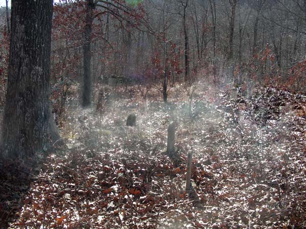
The cemetery is badly overgrown with sapplings and briars, making it difficult to walk. It appears that the cemetery covers about 1/2 acre and there are MANY (probably 50+) graves marked only with fieldstones. The earliest date of burial found on a tombstone here is 1909 and the last burial was in February 1951. There could have been burials prior to this time since the many fieldstones do not have dates on them.
This cemetery is located on private property and is very difficult to find unless you have directions - there is no road leading to the cemetery. It is located on property owned by Steve & Jo Eaton in the North Half of the Northeast Quarter of Section 9, Township 13 North, Range 25 West. We visited this cemetery with Jo Eaton as a guide on 29 December 2011, and we crossed a pasture to reach the cemetery. The Eatons have asked that you contact them before going to the cemetery, since they live here and hunt on their property and need to know when someone is at the cemetery.
It is possible to reach the cemetery by turning South on Madison County Road #4685; then left on Private Drive #4382. The cemetery is located on a hillside about 1/4 mile on #4382, on the left side of the road. But unless you know where to look for it, it would be very difficult to find. Nevertheless, the Eatons still request that you advise them that you would like to go the cemetery before going onto their property. They will gladly give you permission, but just want to know that you're there.
The cemetery is badly overgrown with sapplings and briars, making it difficult to walk. It appears that the cemetery covers about 1/2 acre and there are MANY (probably 50+) graves marked only with fieldstones. The earliest date of burial found on a tombstone here is 1909 and the last burial was in February 1951. There could have been burials prior to this time since the many fieldstones do not have dates on them.
Nearby cemeteries

Pettigrew, Madison County, Arkansas, USA
- Total memorials18
- Percent photographed100%
- Percent with GPS0%

Dutton, Madison County, Arkansas, USA
- Total memorials90
- Percent photographed87%
- Percent with GPS1%

Madison County, Arkansas, USA
- Total memorials4
- Percent photographed100%
- Percent with GPS0%

Madison County, Arkansas, USA
- Total memorials24
- Percent photographed96%
- Percent with GPS0%
- Added: 1 Jan 2000
- Find a Grave Cemetery ID: 56729

Cemetery Photos
This is a carousel with slides. Use Next and Previous buttons to navigate, or jump to a slide with the slide dots. Use Escape keyboard button or the Close button to close the carousel.

Success
Uploading...
Waiting...
Failed
This photo was not uploaded because this cemetery already has 20 photos
This photo was not uploaded because you have already uploaded 5 photos to this cemetery
This photo was not uploaded because you have already uploaded 5 photos to this cemetery
Invalid File Type
Birth and death years unknown.
1 photo picked...
2 photos picked...
Uploading 1 Photo
Uploading 2 Photos
1 Photo Uploaded
2 Photos Uploaded
Size exceeded
Too many photos have been uploaded
"Unsupported file type"
• ##count## of 0 memorials with GPS displayed. Double click on map to view more.No cemeteries found