Likens Cemetery
Marion, Marion County, Ohio, USA
About
-
- Cemetery ID:
Members have Contributed
Advertisement


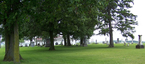
Likens Cemetery is located in Section 12 of Marion Township, Marion County, Ohio, .1 miles south of Likens Road (Marion County Road 167) and .25 miles west of Pole Lane Road (Marion Township Road 174), containing 1.11 acres. The access to the cemetery is via private driveway, a parking area is available between the house and the barns. The earliest confirmed burial occurred 1825. July 6, 1840, John and Anna Zuck gave first plot of land as a general burial ground by deeding a half acre to the Marion Township trustees. Later, additional land was given by Sylvester and Sarah Ann Likens and the cemetery then became the Likens-Zuck Graveyard. By the end of the 1890s, the cemetery was simply known as Likens Cemetery. There is also proof that the cemetery was used during the later part of the 19th and early 20th Century by the county for indigent burials for residents of the Marion County Home, and for infant burials. In those cases, some graves were not marked. In 1942 the cemetery was part of an 11,000-acre takings action by the United States Government. The cemetery, and surrounding land was purchased for the Scioto Ordnance plant, local families were evicted, and the cemetery was closed to civilians on May 1, 1942, however some graves were removed with Government permission for burial elsewhere. At the time of the eviction notice, news reports were that approximately 300 graves were thought to be at Likens. Following the war, and with the descendants of the dead buried in the cemetery relocated to new locations, the cemetery was allowed to fall into disrepair, becoming a bramble of weeds, trees, and high grasses. Monuments were overturned by vandals. Families removed some graves and some stones for reburial. In some cases, just stones, or their foundations, were left behind. A 4-H Club in the area took restoration of the cemetery as their project in the 1970s. They replaced monuments and the land was leveled and cleaned. The cemetery was completely restored by 1975 but later fell into disrepair again. The Cemetery is now tended to, but fewer than 130 markers can be found. Likens Cemetery has never been part of, or overseen by, a religious body or congregation. The final burial was made at Likens Cemetery in 1944, with special approval of the United States Government, however it was later relocated. There are no formal records or maps of the cemetery. Walking's and recordation of the stones were done in 1951 by Elsie E. Rayburn (partial), and a more complete walking was done in 1976 by Paul and Barbara Midlam.
Likens Cemetery is located in Section 12 of Marion Township, Marion County, Ohio, .1 miles south of Likens Road (Marion County Road 167) and .25 miles west of Pole Lane Road (Marion Township Road 174), containing 1.11 acres. The access to the cemetery is via private driveway, a parking area is available between the house and the barns. The earliest confirmed burial occurred 1825. July 6, 1840, John and Anna Zuck gave first plot of land as a general burial ground by deeding a half acre to the Marion Township trustees. Later, additional land was given by Sylvester and Sarah Ann Likens and the cemetery then became the Likens-Zuck Graveyard. By the end of the 1890s, the cemetery was simply known as Likens Cemetery. There is also proof that the cemetery was used during the later part of the 19th and early 20th Century by the county for indigent burials for residents of the Marion County Home, and for infant burials. In those cases, some graves were not marked. In 1942 the cemetery was part of an 11,000-acre takings action by the United States Government. The cemetery, and surrounding land was purchased for the Scioto Ordnance plant, local families were evicted, and the cemetery was closed to civilians on May 1, 1942, however some graves were removed with Government permission for burial elsewhere. At the time of the eviction notice, news reports were that approximately 300 graves were thought to be at Likens. Following the war, and with the descendants of the dead buried in the cemetery relocated to new locations, the cemetery was allowed to fall into disrepair, becoming a bramble of weeds, trees, and high grasses. Monuments were overturned by vandals. Families removed some graves and some stones for reburial. In some cases, just stones, or their foundations, were left behind. A 4-H Club in the area took restoration of the cemetery as their project in the 1970s. They replaced monuments and the land was leveled and cleaned. The cemetery was completely restored by 1975 but later fell into disrepair again. The Cemetery is now tended to, but fewer than 130 markers can be found. Likens Cemetery has never been part of, or overseen by, a religious body or congregation. The final burial was made at Likens Cemetery in 1944, with special approval of the United States Government, however it was later relocated. There are no formal records or maps of the cemetery. Walking's and recordation of the stones were done in 1951 by Elsie E. Rayburn (partial), and a more complete walking was done in 1976 by Paul and Barbara Midlam.
Nearby cemeteries

Brush Ridge, Marion County, Ohio, USA
- Total memorials62
- Percent photographed32%
- Percent with GPS0%

Marion, Marion County, Ohio, USA
- Total memorials6k+
- Percent photographed30%
- Percent with GPS9%

Marion, Marion County, Ohio, USA
- Total memorials250
- Percent photographed26%
- Percent with GPS4%

Marion, Marion County, Ohio, USA
- Total memorials236
- Percent photographed97%
- Percent with GPS1%
- Added: 1 Jan 2000
- Find a Grave Cemetery ID: 41835

Cemetery Photos
This is a carousel with slides. Use Next and Previous buttons to navigate, or jump to a slide with the slide dots. Use Escape keyboard button or the Close button to close the carousel.


Success
Uploading...
Waiting...
Failed
This photo was not uploaded because this cemetery already has 20 photos
This photo was not uploaded because you have already uploaded 5 photos to this cemetery
This photo was not uploaded because you have already uploaded 5 photos to this cemetery
Invalid File Type
Birth and death years unknown.
1 photo picked...
2 photos picked...
Uploading 1 Photo
Uploading 2 Photos
1 Photo Uploaded
2 Photos Uploaded
Size exceeded
Too many photos have been uploaded
"Unsupported file type"
• ##count## of 0 memorials with GPS displayed. Double click on map to view more.No cemeteries found