Pomphrey Island Cemetery
Clearview, Carleton County, New Brunswick, Canada
When Thomas Pomphrey died in December of 1871 he left the cemetery to the Baptist congregation. In his will dated June 4th, 1861 and probated on July 24, 1862 he said the following "I will one acre of land -owned by Richard DeMerchant - were the burying land is bounded as follows on the west by the post road, north by land owned by John Inman, east by the river St. Johns on the south by land owned by James McAllister , to the Free Baptist congregation for the use of that denomination."
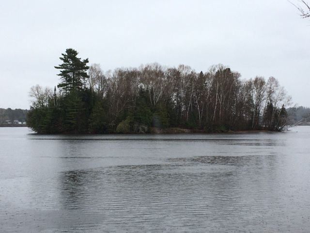
In the early 1950's plans were made to build a hydro electric dam at Beechwood on the St. John River, a few miles down river from the cemetery. The result was a full scale change. Just over half of the cemetery would remain above the flood zone created by the dam and a new island was created. This necessitated the removal of the headstones and known remains of those interned here.
Land was purchased down river next to the site of the Upper Wicklow Baptist Church and most of the headstones were moved here. Today the cemetery is known as the Pomphrey Upper Wicklow Cemetery.
https://www.findagrave.com/cemetery/2340342/pomphrey-cemetery ID- 2340342
There was also land purchased a few kilometers away to the north on the River de Chute Road and given to the Pentecostal Church. Some of the graves for several families were moved here. Most of these names have connections with our neighbours in the United States from the small towns of Easton and Mars Hill. Today it is known as the River de Chute Cemetery.
https://www.findagrave.com/cemetery/2315827/river-de-chute-cemetery ID - 2315827
In 2021 there is only two concrete foundations that were used as the base for headstones left on the island to distinguish it as a cemetery. To this day the remains of early Carleton County pioneers would be on this island and below the flooded St. John River.
2021 Video of Pomphrey Cemetery Island - Pomphrey Cemetery Island Video
When Thomas Pomphrey died in December of 1871 he left the cemetery to the Baptist congregation. In his will dated June 4th, 1861 and probated on July 24, 1862 he said the following "I will one acre of land -owned by Richard DeMerchant - were the burying land is bounded as follows on the west by the post road, north by land owned by John Inman, east by the river St. Johns on the south by land owned by James McAllister , to the Free Baptist congregation for the use of that denomination."
In the early 1950's plans were made to build a hydro electric dam at Beechwood on the St. John River, a few miles down river from the cemetery. The result was a full scale change. Just over half of the cemetery would remain above the flood zone created by the dam and a new island was created. This necessitated the removal of the headstones and known remains of those interned here.
Land was purchased down river next to the site of the Upper Wicklow Baptist Church and most of the headstones were moved here. Today the cemetery is known as the Pomphrey Upper Wicklow Cemetery.
https://www.findagrave.com/cemetery/2340342/pomphrey-cemetery ID- 2340342
There was also land purchased a few kilometers away to the north on the River de Chute Road and given to the Pentecostal Church. Some of the graves for several families were moved here. Most of these names have connections with our neighbours in the United States from the small towns of Easton and Mars Hill. Today it is known as the River de Chute Cemetery.
https://www.findagrave.com/cemetery/2315827/river-de-chute-cemetery ID - 2315827
In 2021 there is only two concrete foundations that were used as the base for headstones left on the island to distinguish it as a cemetery. To this day the remains of early Carleton County pioneers would be on this island and below the flooded St. John River.
2021 Video of Pomphrey Cemetery Island - Pomphrey Cemetery Island Video
Nearby cemeteries

Clearview, Carleton County, New Brunswick, Canada
- Total memorials254
- Percent photographed91%
- Percent with GPS0%

Upper Kent, Carleton County, New Brunswick, Canada
- Total memorials1k+
- Percent photographed70%
- Percent with GPS1%

Upper Kent, Carleton County, New Brunswick, Canada
- Total memorials3
- Percent photographed100%
- Percent with GPS33%

Wicklow, Carleton County, New Brunswick, Canada
- Total memorials188
- Percent photographed91%
- Percent with GPS1%
- Added: 26 May 2021
- Find a Grave Cemetery ID: 2731263

Cemetery Photos
This is a carousel with slides. Use Next and Previous buttons to navigate, or jump to a slide with the slide dots. Use Escape keyboard button or the Close button to close the carousel.
Success
Uploading...
Waiting...
Failed
This photo was not uploaded because this cemetery already has 20 photos
This photo was not uploaded because you have already uploaded 5 photos to this cemetery
This photo was not uploaded because you have already uploaded 5 photos to this cemetery
Invalid File Type
Birth and death years unknown.
1 photo picked...
2 photos picked...
Uploading 1 Photo
Uploading 2 Photos
1 Photo Uploaded
2 Photos Uploaded
Size exceeded
Too many photos have been uploaded
"Unsupported file type"
• ##count## of 0 memorials with GPS displayed. Double click on map to view more.No cemeteries found