St Mary Churchyard
Swaffham Bulbeck, East Cambridgeshire District, Cambridgeshire, England
About
-
Get directions High Street
Swaffham Bulbeck, East Cambridgeshire District, Cambridgeshire CB25 0LX EnglandCoordinates: 52.23637, 0.27625 - Cemetery ID:
Members have Contributed
Advertisement
Photos


The village is situated on Swaffham Lode, a navigable cut or canal, from the river Cam.
It is located just beyond the end of Swaffham Bulbeck Lode, a man-made waterway connected to the River Cam. The Hamlet of Commercial End, at the northern edge of the village, was an important inland port from medieval times, although the waterway had been in use since Roman times. It was the Romans who dug this canal to allow trade between their various farms and villages. The history of the area however can be traced back to the Bronze Age, at least a thousand years before the Roman occupation of Britain. Nearby are the remains of a Benedictine nunnery, founded by one of the Bolebecks/Bolebecs in the reign of King John [of Magna Carta fame] hence ‘Bulbeck'. That line came over from Rouen in Normandy, soon after the Norman Conquest and they established a manor house and founded a small convent of nuns in about 1150. Some remains of the convent still exist at `The Abbey.' Swaffham means a farm or settlement of the Swabians, a tribe from south-west Germany who settled in the area in the sixth century.
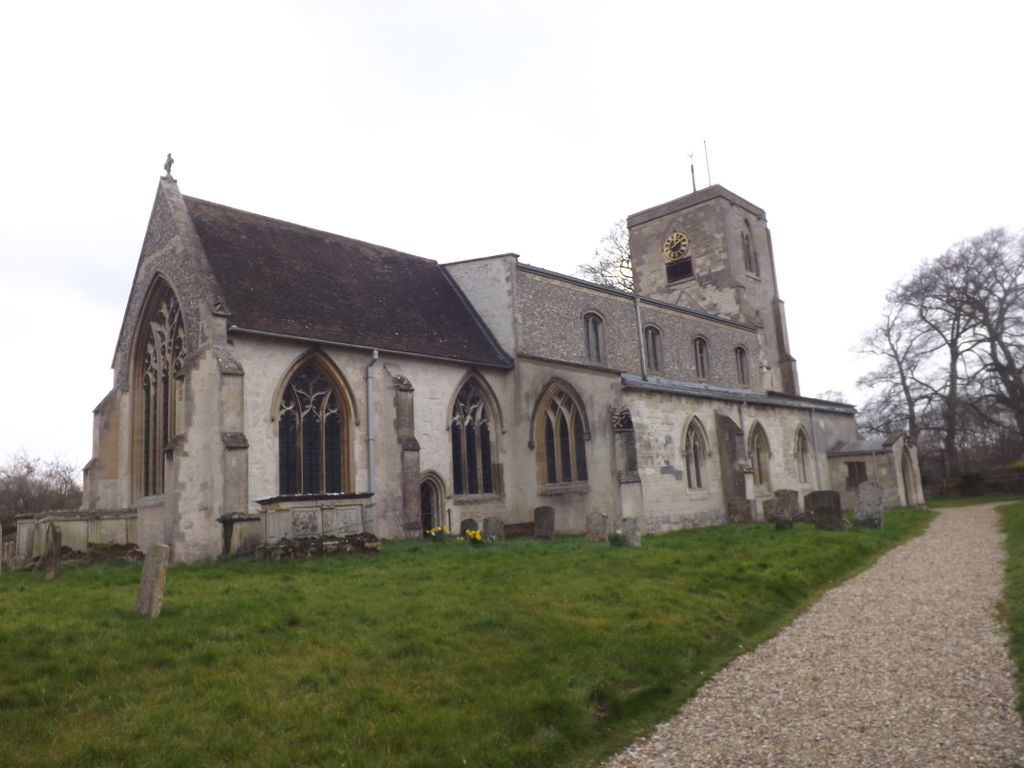
The church is dedicated to St Mary the Virgin. The west tower was built in the early 13th century and is the most ancient part of a very ancient building. The tower is 12.5 feet square with three storeys and is supported by eight buttresses. It is built of locally quarried clunch (from Burwell).
There is also a cemetery in the village which opened in 1877.
The village is situated on Swaffham Lode, a navigable cut or canal, from the river Cam.
It is located just beyond the end of Swaffham Bulbeck Lode, a man-made waterway connected to the River Cam. The Hamlet of Commercial End, at the northern edge of the village, was an important inland port from medieval times, although the waterway had been in use since Roman times. It was the Romans who dug this canal to allow trade between their various farms and villages. The history of the area however can be traced back to the Bronze Age, at least a thousand years before the Roman occupation of Britain. Nearby are the remains of a Benedictine nunnery, founded by one of the Bolebecks/Bolebecs in the reign of King John [of Magna Carta fame] hence ‘Bulbeck'. That line came over from Rouen in Normandy, soon after the Norman Conquest and they established a manor house and founded a small convent of nuns in about 1150. Some remains of the convent still exist at `The Abbey.' Swaffham means a farm or settlement of the Swabians, a tribe from south-west Germany who settled in the area in the sixth century.
The church is dedicated to St Mary the Virgin. The west tower was built in the early 13th century and is the most ancient part of a very ancient building. The tower is 12.5 feet square with three storeys and is supported by eight buttresses. It is built of locally quarried clunch (from Burwell).
There is also a cemetery in the village which opened in 1877.
Nearby cemeteries

Swaffham Bulbeck, East Cambridgeshire District, Cambridgeshire, England
- Total memorials7
- Percent photographed100%
- Percent with GPS0%

Bottisham, East Cambridgeshire District, Cambridgeshire, England
- Total memorials24
- Percent photographed63%
- Percent with GPS0%

Bottisham, East Cambridgeshire District, Cambridgeshire, England
- Total memorials100
- Percent photographed21%
- Percent with GPS0%

Swaffham Prior, East Cambridgeshire District, Cambridgeshire, England
- Total memorials935
- Percent photographed2%
- Percent with GPS0%
- Added: 23 Mar 2016
- Find a Grave Cemetery ID: 2607645

Cemetery Photos
This is a carousel with slides. Use Next and Previous buttons to navigate, or jump to a slide with the slide dots. Use Escape keyboard button or the Close button to close the carousel.


Success
Uploading...
Waiting...
Failed
This photo was not uploaded because this cemetery already has 20 photos
This photo was not uploaded because you have already uploaded 5 photos to this cemetery
This photo was not uploaded because you have already uploaded 5 photos to this cemetery
Invalid File Type
Birth and death years unknown.
1 photo picked...
2 photos picked...
Uploading 1 Photo
Uploading 2 Photos
1 Photo Uploaded
2 Photos Uploaded
Size exceeded
Too many photos have been uploaded
"Unsupported file type"
• ##count## of 0 memorials with GPS displayed. Double click on map to view more.No cemeteries found