Capitola Cemetery
Also known as Register-Wallace Cemetery
Capitola, Leon County, Florida, USA
About
-
Get directions Whitehouse Road
Capitola, Florida 32317 United StatesCoordinates: 30.44371, -84.08406 - Cemetery ID:
Members have Contributed
Advertisement
Photos
No additional photos.
Add PhotosOn November 7th 2015 I was contacted by a Gentleman, who grew up in the Capitola Community living less than 1 mile from this cemetery, he stated that the correct name for this cemetery is: CAPITOLA CEMETERY and that it was named for Capitola Dupree who was the first to be buried here.
February 1, 2016 This land has been completely cleared, anyone wishing to go to the cemetery and stand the headstones up, would have no problem finding the cemetery, following the directions from Whitehouse Road. This property has been sold and cleared of trees.
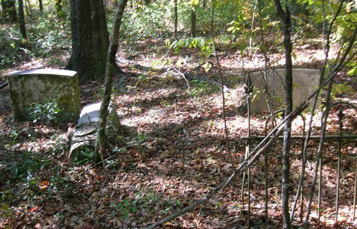
I personally went and researched this cemetery early Oct. 2015, It has been widely mowed around the complete outside of cemetery, the fencing is falling down. Many of the stones are tipped over. Unfortunately I am not strong enough to right them by myself. I entered by Whitehouse Road directions. The cemetery is about a 8-10 minute walk back, I marked it with pink ribbons, once you get to the cemetery on your right - you will see the ribbon. The gate is red and the group of mailboxes are black - the gate is across the road from Mamie Lane. It would probably take 2 men to stand the stones back up.
This small cemetery is located on land belonging to St. Joe Paper Co. It is suggested that you contact them before entering to let them know, you plan to visit the Capitola Cemetery, (because it is a cemetery they can not tell you no, unless they are harvesting trees - very unlikely). There are 2 ways to access the cemetery.
Whitehouse Road is probably the easiest and most direct. From Chaires Crossroads and Highway 27 intersection, go north on Chaires Crossroad, until you reach the 4 way stop sign, (you will also see railroad tracks in front of you) turn right at stop sign, this is Capitola Road, travel east (go approx. 3 miles - you will pass Benjamin Chaires Rd, and Baum Road both on you left - so you know you are headed the correct direction)once you pass Baum Road - slow down - you will pass a small country store on your right, 1 block down turn right onto Whitehouse Road, you will go about 2 blocks and the road takes a sharp left turn - once you go thru the curve, start looking for a group of mailboxes on your right - you will see a wide dirt/grass road with a metal gate across drive. You will need to park your car and walk to the cemetery. It is probably less than a 15 minute walk, follow the road/trail (The road keeps going to a pond if you reach it turn around you went to far - as of August 2015, the land is not to thick or heavily wooded, due to clearing that has been done in the last year - this land is for sale so they are keeping it thinner than usual) - a great time to research and take photographs.
ALTERNATIVE DIRECTIONS - According to usgen archives this is their directions: (Hint: follow my directions until you get just pass Baum Road, then turn right onto Captram Road Before the country store) Their Directions: From US 27, south of Tallahassee (actually heading east), turn left
on W.W. Kelly Road (Hint: this road is called Chaires Crossroad not WW Kelly once you cross Highway 27). Just before you cross the railroad tracks at a marked crossing,
bear right on Capitola Road. Turn right on Captram Road - this is a dirt road. Go past a number of houses to an area where there aren't any on the left. There are two posts with the entrance chained off. The area is marked No Trespassing, St. Joe Paper Company. You should get permission from St. Joe to enter this trail. There was once
an alternate way to the cemetery from Whitehouse Road, but we could not locate it. (if you prefer to take the Whitehouse Road Trail - directions are above)
The cemetery is an 8 minute walk from the entrance on Captram Road. Stay on the trail.
When you come to a big clearing, there will be trails to left, center and right.
There is a small sinkhole or pond on the right. Take the trail that bears to the left.
You're about halfway there.
The cemetery is located in a heavily wooded area, and is approximately 50 feet from the
trail on the left side. On the trail, heading 52 degrees from N, the cemetery is on the
left under the trees. It's easy to miss as the shade from the trees obscures it. It is
surrounded by an iron fence, and sections are missing. It is approximately 52 x 45 feet
in size. The graves appear to be in four rows, but the condition is so bad that there
may be others we didn't see. Credit to: Kim Dupree for the Captram Road directions.
On November 7th 2015 I was contacted by a Gentleman, who grew up in the Capitola Community living less than 1 mile from this cemetery, he stated that the correct name for this cemetery is: CAPITOLA CEMETERY and that it was named for Capitola Dupree who was the first to be buried here.
February 1, 2016 This land has been completely cleared, anyone wishing to go to the cemetery and stand the headstones up, would have no problem finding the cemetery, following the directions from Whitehouse Road. This property has been sold and cleared of trees.
I personally went and researched this cemetery early Oct. 2015, It has been widely mowed around the complete outside of cemetery, the fencing is falling down. Many of the stones are tipped over. Unfortunately I am not strong enough to right them by myself. I entered by Whitehouse Road directions. The cemetery is about a 8-10 minute walk back, I marked it with pink ribbons, once you get to the cemetery on your right - you will see the ribbon. The gate is red and the group of mailboxes are black - the gate is across the road from Mamie Lane. It would probably take 2 men to stand the stones back up.
This small cemetery is located on land belonging to St. Joe Paper Co. It is suggested that you contact them before entering to let them know, you plan to visit the Capitola Cemetery, (because it is a cemetery they can not tell you no, unless they are harvesting trees - very unlikely). There are 2 ways to access the cemetery.
Whitehouse Road is probably the easiest and most direct. From Chaires Crossroads and Highway 27 intersection, go north on Chaires Crossroad, until you reach the 4 way stop sign, (you will also see railroad tracks in front of you) turn right at stop sign, this is Capitola Road, travel east (go approx. 3 miles - you will pass Benjamin Chaires Rd, and Baum Road both on you left - so you know you are headed the correct direction)once you pass Baum Road - slow down - you will pass a small country store on your right, 1 block down turn right onto Whitehouse Road, you will go about 2 blocks and the road takes a sharp left turn - once you go thru the curve, start looking for a group of mailboxes on your right - you will see a wide dirt/grass road with a metal gate across drive. You will need to park your car and walk to the cemetery. It is probably less than a 15 minute walk, follow the road/trail (The road keeps going to a pond if you reach it turn around you went to far - as of August 2015, the land is not to thick or heavily wooded, due to clearing that has been done in the last year - this land is for sale so they are keeping it thinner than usual) - a great time to research and take photographs.
ALTERNATIVE DIRECTIONS - According to usgen archives this is their directions: (Hint: follow my directions until you get just pass Baum Road, then turn right onto Captram Road Before the country store) Their Directions: From US 27, south of Tallahassee (actually heading east), turn left
on W.W. Kelly Road (Hint: this road is called Chaires Crossroad not WW Kelly once you cross Highway 27). Just before you cross the railroad tracks at a marked crossing,
bear right on Capitola Road. Turn right on Captram Road - this is a dirt road. Go past a number of houses to an area where there aren't any on the left. There are two posts with the entrance chained off. The area is marked No Trespassing, St. Joe Paper Company. You should get permission from St. Joe to enter this trail. There was once
an alternate way to the cemetery from Whitehouse Road, but we could not locate it. (if you prefer to take the Whitehouse Road Trail - directions are above)
The cemetery is an 8 minute walk from the entrance on Captram Road. Stay on the trail.
When you come to a big clearing, there will be trails to left, center and right.
There is a small sinkhole or pond on the right. Take the trail that bears to the left.
You're about halfway there.
The cemetery is located in a heavily wooded area, and is approximately 50 feet from the
trail on the left side. On the trail, heading 52 degrees from N, the cemetery is on the
left under the trees. It's easy to miss as the shade from the trees obscures it. It is
surrounded by an iron fence, and sections are missing. It is approximately 52 x 45 feet
in size. The graves appear to be in four rows, but the condition is so bad that there
may be others we didn't see. Credit to: Kim Dupree for the Captram Road directions.
Nearby cemeteries

Capitola, Leon County, Florida, USA
- Total memorials17
- Percent photographed88%
- Percent with GPS0%
- Added: 18 Aug 2015
- Find a Grave Cemetery ID: 2588092

Cemetery Photos
This is a carousel with slides. Use Next and Previous buttons to navigate, or jump to a slide with the slide dots. Use Escape keyboard button or the Close button to close the carousel.
Success
Uploading...
Waiting...
Failed
This photo was not uploaded because this cemetery already has 20 photos
This photo was not uploaded because you have already uploaded 5 photos to this cemetery
This photo was not uploaded because you have already uploaded 5 photos to this cemetery
Invalid File Type
Birth and death years unknown.
1 photo picked...
2 photos picked...
Uploading 1 Photo
Uploading 2 Photos
1 Photo Uploaded
2 Photos Uploaded
Size exceeded
Too many photos have been uploaded
"Unsupported file type"
• ##count## of 0 memorials with GPS displayed. Double click on map to view more.No cemeteries found