Hite Family Cemetery
Louisville, Jefferson County, Kentucky, USA
About
-
Get directions next to 4218 Morgan Jaymes Drive. Watterson Trail to Morgan Jaymes Dr. (Watterson Woods subdivision)
Louisville, Kentucky, USACoordinates: 38.18358, -85.58677 - Cemetery ID:
Members have Contributed
Advertisement
Photos


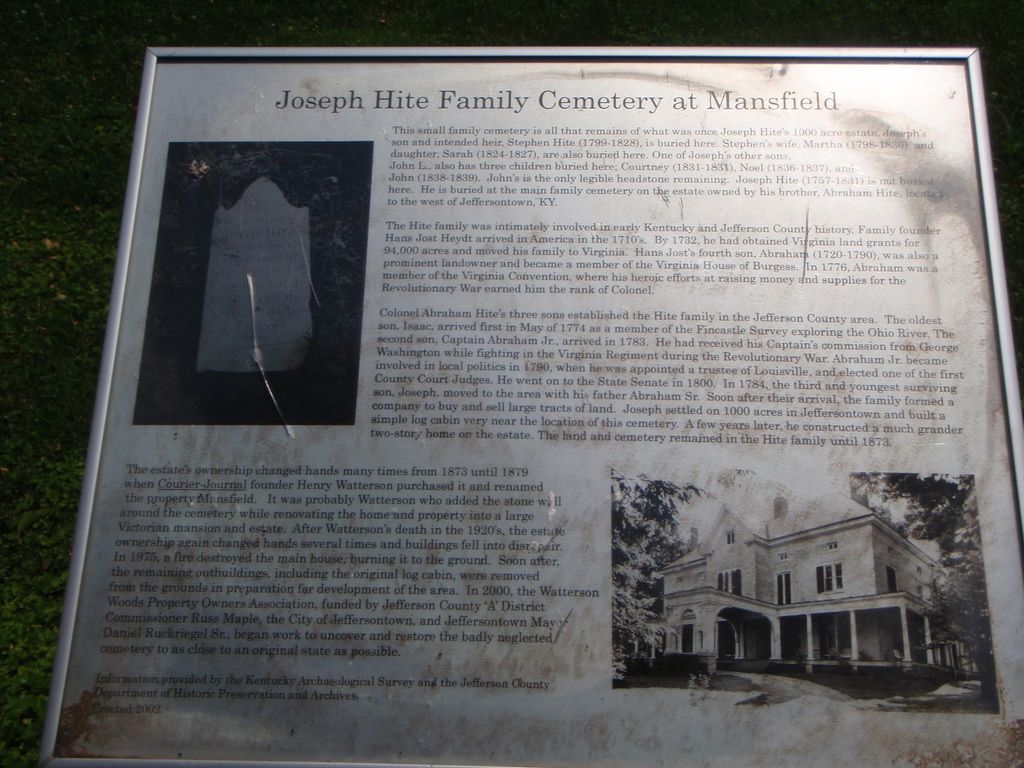
The Hite family was intimately involved in early Kentucky and Jefferson County history. Family founder Hans Jost Heydt arrived in America in the 1710s. By 1732, he had obtained Virginia land grants for 94,000 acres and moved his family to Virginia. Hans Jost's fourth son, Abraham (1720-1790), was also a prominent landowner and became a member of the Virginia Convention, where his heroic efforts at raising money and supplies for the Revolutionary War earned him the rank of Colonel.
Colonel Abraham Hite's three sons established the Hite family in the Jefferson County area. The oldest son, Isaac, arrived first, in May of 1774, as a member of the Fincastle survey exploring the Ohio River. The second son, Captain Abraham, Jr., arrived in 1783. He had received his captain's commission from George Washington. While fighting in the Virginia Regiment during the Revolutionary War, Abraham, Jr. became involved in politics in 1790, when he was appointed as a Trustee of Louisville, and elected one of the first County Court Judges. He went on to the State Senate in 1800. In 1874, the third and youngest surviving son, Joseph, moved to the area with his father, Abraham, Sr. Soon after their arrival, the family formed a company to buy and sell large tracts of land. Joseph settled on 1000 acres in Jeffersontown and built a simple log cabin very near the location of this cemetery. A few years later, he constructed a much grander 2-story home on the estate. The land and cemetery remained in the Hite family until 1873. The estate's ownership changed hands many times from 1873-1879, when Courier-Journal founder Henry Watterson purchased it and renamed the property "Mansfield." It was probably Watterson who added the stone wall around the cemetery while renovating the home and property into a large Victorian mansion and estate. After Watterson's death in the 1920s, the estate ownership again changed hands several times and the buildings fell into disrepair. In 1975, a fire destroyed the main house, burning it to the ground. Soon after, the remaining outbuildings, including the original log cabin, were removed from the grounds in preparation for the development of the area. In 2000, the Watterson Woods Property Owners Association, founded by Jefferson County 'A' District Commissioner Russ Maple, the City of Jeffersontown, and Jeffersontown Mayor Daniel Ruckriegel, Sr. began work to uncover and restore the badly neglected cemetery to as close to an original state as possible.
(Information provided by the Kentucky Archaeological Survey and the Jefferson County Dept. of Historic Preservation & Archives. Erected 2002).
As of 6/7/2015, all of the stones are unreadable.
(submitted by Ellen White)
Nearby cemeteries

Jeffersontown, Jefferson County, Kentucky, USA
- Total memorials188
- Percent photographed85%
- Percent with GPS1%

Jeffersontown, Jefferson County, Kentucky, USA
- Total memorials810
- Percent photographed91%
- Percent with GPS6%

Fern Creek, Jefferson County, Kentucky, USA
- Total memorials4
- Percent photographed100%
- Percent with GPS0%

Jeffersontown, Jefferson County, Kentucky, USA
- Total memorials2k+
- Percent photographed88%
- Percent with GPS3%
- Added: 11 Jun 2015
- Find a Grave Cemetery ID: 2581571

Cemetery Photos
This is a carousel with slides. Use Next and Previous buttons to navigate, or jump to a slide with the slide dots. Use Escape keyboard button or the Close button to close the carousel.


Success
Uploading...
Waiting...
Failed
This photo was not uploaded because this cemetery already has 20 photos
This photo was not uploaded because you have already uploaded 5 photos to this cemetery
This photo was not uploaded because you have already uploaded 5 photos to this cemetery
Invalid File Type
Birth and death years unknown.
1 photo picked...
2 photos picked...
Uploading 1 Photo
Uploading 2 Photos
1 Photo Uploaded
2 Photos Uploaded
Size exceeded
Too many photos have been uploaded
"Unsupported file type"
• ##count## of 0 memorials with GPS displayed. Double click on map to view more.No cemeteries found