All Saints Anglican Cemetery
Also known as South Victoria Cemetery
Stonewall, South Interlake Census Division, Manitoba, Canada
About
-
Get directions 8126E Provincial Road 81N
Stonewall, Manitoba
R0C 0H0 CanadaCoordinates: 50.19690, -97.25822 - www.rockwood.ca/p/cemeteries
- [email protected]
- +1-204-467-2272
-
Office Address
Rural Municipality of Rockwood
285 Main Street
PO Box 902
Stonewall, Manitoba
R0C 2Z0 Canada - Cemetery ID:
-
Additional information
Located NE of the community of Stonewall, MB, on the north side of Provincial Road 81N, about 0.2 miles (0.3 km) west of Provincial Highway 7
There is no network of improved roadways providing vehicular access to the grounds.
The cemetery is managed by a local committee, whose current contact information is available on the RM of Rockwood website [2024/02].
Members have Contributed
Advertisement
Photos

In speaking of our pioneer settlers, one cannot help think of the faith and fortitude they must have possesed to come out to a new land with very little more than a few personal belongings and perhaps a team of oxen and crude implements.
The Township of Victoria was surveyed between the 22nd of October and the 20th of November, 1872.
As time went on settlers came into the Victoria district from the Red River settlement and from Ontario. One group of the earliest and most prominent settlers were members of a Vincent family of fourteen. They were descendants of a Thomas Vincent, who, as a mere youth, in 1790, came out to Canada, in the service of the Hudson's Bay Company. Although he returned to England when his retirement was due, several sons of his numerous family, remained in Canada, in Company service, and as many other Hudson's Bay men did, retired to the growing Red River settlement. These settlers and their families played a foremost part in the early development of school, church, and state in the Victoria district.
In the early (18)70's, Rev. S. P. Matheson, later Archbishop and Primate of all Rupert's Land, followed his old neighbors of Middlechurch to Victoria district and became first student minister to hold Anglican services in this parish. His first service was held in the home of Robert Good, in Rockwood, and he had charge of the area from north of where Teulon now stands to as far south as Stony Mountain.
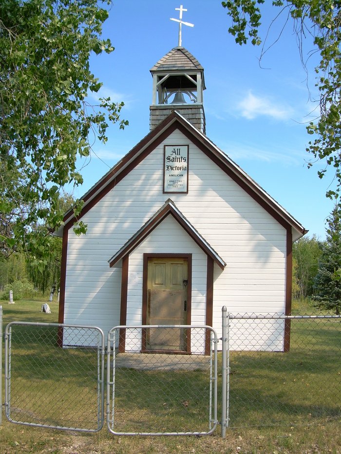
In 1876, when Rev. Matheson was in England, he collected a small sum of money towards the building of a church at Victoria. He received contributions from some of his relations on condition that the church be called "All Saints"' after one of the parish churches in Shrewsbury, England. With the money he collected he purchased the lumber which was hauled out from Winnipeg by ox team.
The Victoria church was the first one built outside of the Red River belt, but Springfield was next, so All Saint's is historically the mother church of this parish.
At the 62nd anniversary the sole survivor of those who had attended the dedication service was Mr. Joseph Bruce. Later on, Mr. Bruce also passed away to rest and was buried in the cemetery.
(Source: Rockwood Echoes - 90 Years of Progress (1870 - 1960), p 95, p 282 [1960; Adapted])
(The Post Office in) Victoria opened August 1st, 1878, with Mr. John Vincent as Postmaster, succeeded by Chas. Sibbald, the same year. Next James Grahame, April 1st, 1879, and W D. Polson, April 1st, 1889. and name changed to Wavy Bank; then Cecil Ilerbert, July 1st, 1897. then Albert Waterer and James Croy, final Postmaster.
(Source: 100 Years of History, Rockwood Municipality, p 50 [1984; Adapted])
~~~~~~~~~~
Established in 1879.
From the markers, it appears the first death was that of Wellington Hill Goodwho died April 20 1879.
(Source: Manitoba Genealogical Society [Adapted])
By the 1860s, the increasingly crowded settlements along Manitoba's rivers (in and around the Red River Settlement) were forcing people to venture out onto the open prairies for better farming opportunities. One of the first such areas opened was the Victoria district, near present-day Stonewall.
The first minister here, Reverend Samuel Matheson, began raising funds in 1876 and by 1877 an Anglican church was completed. After his service at All Saints, Matheson went on to become Canon of St. John's Cathedral, Professor of Theology at St. John's College, Archbishop of Rupert's Land and, in 1909, Primate of All Canada. He returned to All Saints Victoria on 9 October 1927 to conduct the church's 50th anniversary service.
The church building was renovated in 1983 and is a provincially-designated historic site.
(Source: Manitoba Historical Society [Adapted])
~~~~~~~~~~
Dominion Land Survey coordinates: LSD01-21-14-02-E1
In the Rural Municipality of Rockwood
~~~~~~~~~~
As noted above, a part of the community's story, and those of its inhabitants, from the early days of European settlement through roughly 1982 is told in the pair of related volumes "Rockwood Echoes - 90 Years of Progress (1870 - 1960)" and "100 Years of History, Rockwood Municipality", especially on the cited pages.
Free digital versions of these and many other Manitoba local history books can be found online in the University of Manitoba Digital Collections. There is also a list of such books organized by district and town name on the Manitoba Historical Society's website on their page entitled "Finding Aid: Manitoba Local History Books".
A list of burials in this cemetery is available from the Manitoba Genealogical Society (reference #0204), transcribed by a member or members in 1986 and updated in 2001. Also available to MGS members is a searchable online database named the "MGS Manitoba Name Index" (or MANI). Some additional information is contained in the 1996 MGS publication "Carved in Stone: Manitoba Cemeteries and Burial Sites" (revised edition, Special Projects Publication, 106 pages).
~~~~~~~~~~
Additionally, many records for Anglican congregations in Manitoba and over part of the territory designated historically as "Rupert's Land" (esp, as bounded on the south by the U.S. border, extending north into the Manitoba Interlake Region past Fairford, with the western boundary reaching into the Pembina Hills and includes Portage la Prairie, eastward the diocese stretches to Sioux Lookout/Atikokan) are now with the Diocese of Rupert's Land and are kept in their offices in Winnipeg, Manitoba, Canada.
~~~~~~~~~~
THE CHURCH BUILDING ASSOCIATED WITH THIS CEMETERY is recognized as a Provincial Heritage Site by the Government of Manitoba Historic Resources Branch (#097)
In speaking of our pioneer settlers, one cannot help think of the faith and fortitude they must have possesed to come out to a new land with very little more than a few personal belongings and perhaps a team of oxen and crude implements.
The Township of Victoria was surveyed between the 22nd of October and the 20th of November, 1872.
As time went on settlers came into the Victoria district from the Red River settlement and from Ontario. One group of the earliest and most prominent settlers were members of a Vincent family of fourteen. They were descendants of a Thomas Vincent, who, as a mere youth, in 1790, came out to Canada, in the service of the Hudson's Bay Company. Although he returned to England when his retirement was due, several sons of his numerous family, remained in Canada, in Company service, and as many other Hudson's Bay men did, retired to the growing Red River settlement. These settlers and their families played a foremost part in the early development of school, church, and state in the Victoria district.
In the early (18)70's, Rev. S. P. Matheson, later Archbishop and Primate of all Rupert's Land, followed his old neighbors of Middlechurch to Victoria district and became first student minister to hold Anglican services in this parish. His first service was held in the home of Robert Good, in Rockwood, and he had charge of the area from north of where Teulon now stands to as far south as Stony Mountain.
In 1876, when Rev. Matheson was in England, he collected a small sum of money towards the building of a church at Victoria. He received contributions from some of his relations on condition that the church be called "All Saints"' after one of the parish churches in Shrewsbury, England. With the money he collected he purchased the lumber which was hauled out from Winnipeg by ox team.
The Victoria church was the first one built outside of the Red River belt, but Springfield was next, so All Saint's is historically the mother church of this parish.
At the 62nd anniversary the sole survivor of those who had attended the dedication service was Mr. Joseph Bruce. Later on, Mr. Bruce also passed away to rest and was buried in the cemetery.
(Source: Rockwood Echoes - 90 Years of Progress (1870 - 1960), p 95, p 282 [1960; Adapted])
(The Post Office in) Victoria opened August 1st, 1878, with Mr. John Vincent as Postmaster, succeeded by Chas. Sibbald, the same year. Next James Grahame, April 1st, 1879, and W D. Polson, April 1st, 1889. and name changed to Wavy Bank; then Cecil Ilerbert, July 1st, 1897. then Albert Waterer and James Croy, final Postmaster.
(Source: 100 Years of History, Rockwood Municipality, p 50 [1984; Adapted])
~~~~~~~~~~
Established in 1879.
From the markers, it appears the first death was that of Wellington Hill Goodwho died April 20 1879.
(Source: Manitoba Genealogical Society [Adapted])
By the 1860s, the increasingly crowded settlements along Manitoba's rivers (in and around the Red River Settlement) were forcing people to venture out onto the open prairies for better farming opportunities. One of the first such areas opened was the Victoria district, near present-day Stonewall.
The first minister here, Reverend Samuel Matheson, began raising funds in 1876 and by 1877 an Anglican church was completed. After his service at All Saints, Matheson went on to become Canon of St. John's Cathedral, Professor of Theology at St. John's College, Archbishop of Rupert's Land and, in 1909, Primate of All Canada. He returned to All Saints Victoria on 9 October 1927 to conduct the church's 50th anniversary service.
The church building was renovated in 1983 and is a provincially-designated historic site.
(Source: Manitoba Historical Society [Adapted])
~~~~~~~~~~
Dominion Land Survey coordinates: LSD01-21-14-02-E1
In the Rural Municipality of Rockwood
~~~~~~~~~~
As noted above, a part of the community's story, and those of its inhabitants, from the early days of European settlement through roughly 1982 is told in the pair of related volumes "Rockwood Echoes - 90 Years of Progress (1870 - 1960)" and "100 Years of History, Rockwood Municipality", especially on the cited pages.
Free digital versions of these and many other Manitoba local history books can be found online in the University of Manitoba Digital Collections. There is also a list of such books organized by district and town name on the Manitoba Historical Society's website on their page entitled "Finding Aid: Manitoba Local History Books".
A list of burials in this cemetery is available from the Manitoba Genealogical Society (reference #0204), transcribed by a member or members in 1986 and updated in 2001. Also available to MGS members is a searchable online database named the "MGS Manitoba Name Index" (or MANI). Some additional information is contained in the 1996 MGS publication "Carved in Stone: Manitoba Cemeteries and Burial Sites" (revised edition, Special Projects Publication, 106 pages).
~~~~~~~~~~
Additionally, many records for Anglican congregations in Manitoba and over part of the territory designated historically as "Rupert's Land" (esp, as bounded on the south by the U.S. border, extending north into the Manitoba Interlake Region past Fairford, with the western boundary reaching into the Pembina Hills and includes Portage la Prairie, eastward the diocese stretches to Sioux Lookout/Atikokan) are now with the Diocese of Rupert's Land and are kept in their offices in Winnipeg, Manitoba, Canada.
~~~~~~~~~~
THE CHURCH BUILDING ASSOCIATED WITH THIS CEMETERY is recognized as a Provincial Heritage Site by the Government of Manitoba Historic Resources Branch (#097)
Nearby cemeteries

Balmoral, South Interlake Census Division, Manitoba, Canada
- Total memorials682
- Percent photographed95%
- Percent with GPS5%
Balmoral, South Interlake Census Division, Manitoba, Canada
- Total memorials0
- Percent photographed0%
- Percent with GPS0%

Stonewall, South Interlake Census Division, Manitoba, Canada
- Total memorials2k+
- Percent photographed94%
- Percent with GPS12%

Stony Mountain, South Interlake Census Division, Manitoba, Canada
- Total memorials102
- Percent photographed90%
- Percent with GPS3%
- Added: 13 May 2012
- Find a Grave Cemetery ID: 2449036

Cemetery Photos
This is a carousel with slides. Use Next and Previous buttons to navigate, or jump to a slide with the slide dots. Use Escape keyboard button or the Close button to close the carousel.

Success
Uploading...
Waiting...
Failed
This photo was not uploaded because this cemetery already has 20 photos
This photo was not uploaded because you have already uploaded 5 photos to this cemetery
This photo was not uploaded because you have already uploaded 5 photos to this cemetery
Invalid File Type
Birth and death years unknown.
1 photo picked...
2 photos picked...
Uploading 1 Photo
Uploading 2 Photos
1 Photo Uploaded
2 Photos Uploaded
Size exceeded
Too many photos have been uploaded
"Unsupported file type"
• ##count## of 0 memorials with GPS displayed. Double click on map to view more.No cemeteries found