Troxel Cemetery
Also known as Truxel Cemetery
Mount Pleasant, Westmoreland County, Pennsylvania, USA – *No GPS coordinates
About
-
No location information available
Add Location - Cemetery ID:
Members have Contributed
- 15 Memorials
- 67% photographed
- No location information available Add Location
Advertisement
Photos


The farm on which this cemetery is situated was owned by M. Troxel in the year 1867, as shown in the Atlas of Westmoreland County, Pennsylvania, from actual surveys and under the direction of S.N. & D.G. Beers, published by A. Pomeroy, #320 Chestnut Street, Philadelphia, 1867, and entered according to Act of Congress in the year 1867, by A. Pomeroy in the Clerk's Office of the District Court of the Eastern District of Pennsylvania.
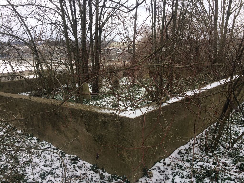
The cemetery is situated in a field to the right of route #819, traveling from Mount Pleasant to West Overton. It is enclosed with a cement wall, and is approximately 40' x 40' in size. The stones are in bad condition, many of them broken and scaled off; not legible.
The farm now is owned by a Mr. Lemmon (1947), whose address is R.D.#2, Mount Pleasant, Penna., and is about one-half mile from Mount Pleasant, which road is the main thoroughfare between Mount Pleasant and Connellsville, Fayette County, Penna.
These Cemetery Records were copied November 19, 1946 by two Members of Braddock Trail Chapter, National Society, Daughters of the American Revolution, Mount Pleasant, Penna.
The farm on which this cemetery is situated was owned by M. Troxel in the year 1867, as shown in the Atlas of Westmoreland County, Pennsylvania, from actual surveys and under the direction of S.N. & D.G. Beers, published by A. Pomeroy, #320 Chestnut Street, Philadelphia, 1867, and entered according to Act of Congress in the year 1867, by A. Pomeroy in the Clerk's Office of the District Court of the Eastern District of Pennsylvania.
The cemetery is situated in a field to the right of route #819, traveling from Mount Pleasant to West Overton. It is enclosed with a cement wall, and is approximately 40' x 40' in size. The stones are in bad condition, many of them broken and scaled off; not legible.
The farm now is owned by a Mr. Lemmon (1947), whose address is R.D.#2, Mount Pleasant, Penna., and is about one-half mile from Mount Pleasant, which road is the main thoroughfare between Mount Pleasant and Connellsville, Fayette County, Penna.
These Cemetery Records were copied November 19, 1946 by two Members of Braddock Trail Chapter, National Society, Daughters of the American Revolution, Mount Pleasant, Penna.
Nearby cemeteries

Mount Pleasant, Westmoreland County, Pennsylvania, USA
- Total memorials9k+
- Percent photographed64%
- Percent with GPS7%

Mount Pleasant, Westmoreland County, Pennsylvania, USA
- Total memorials2k+
- Percent photographed88%
- Percent with GPS0%

Mount Pleasant, Westmoreland County, Pennsylvania, USA
- Total memorials2k+
- Percent photographed89%
- Percent with GPS0%

Mount Pleasant, Westmoreland County, Pennsylvania, USA
- Total memorials2k+
- Percent photographed84%
- Percent with GPS0%
- Added: 15 Jan 2012
- Find a Grave Cemetery ID: 2433595

Cemetery Photos
This is a carousel with slides. Use Next and Previous buttons to navigate, or jump to a slide with the slide dots. Use Escape keyboard button or the Close button to close the carousel.


Success
Uploading...
Waiting...
Failed
This photo was not uploaded because this cemetery already has 20 photos
This photo was not uploaded because you have already uploaded 5 photos to this cemetery
This photo was not uploaded because you have already uploaded 5 photos to this cemetery
Invalid File Type
Birth and death years unknown.
1 photo picked...
2 photos picked...
Uploading 1 Photo
Uploading 2 Photos
1 Photo Uploaded
2 Photos Uploaded
Size exceeded
Too many photos have been uploaded
"Unsupported file type"
• ##count## of 0 memorials with GPS displayed. Double click on map to view more.No cemeteries found