Knightville Cemetery
Huntington, Hampshire County, Massachusetts, USA
About
-
- This cemetery is marked as being historical or removed.
- No longer accepting burials
- Cemetery ID:
Members have Contributed
Advertisement
Photos
No additional photos.
Add PhotosThe markers from Indian Hollow and Knightville Cemeteries were removed as part of a flood control project that created Knightville Reservoir in 1939-40. A burial permit was issued by the Town Clerk's Office, Huntington, MA for each marker (or person on the marker). Each permit stub has a transcription of the gravestone. Unless a family member had the remains exhumed and moved, the remains were left in place. Soil from the original grave accompanied the marker and was placed under it at its new location in Norwich Bridge Cemetery
The markers are at the top of the cemetery hill. Their location is marked with a boulder and plaque, "The graves in this back section were moved from the Knightville and Indian Hollow cemeteries due to the construction of Knightville Dam in 1939. There are 54 unknown graves."
Walter Corbin transcribed the cemetery on 22 July 1936. At that time, he found 90 legible markers.
The cemetery was located outside the center of Knightville. Elias Rude sold the ground for the cemetery for $25.00 if the village would form a cemetery association. Although the association was formed, the $25.00 never was paid so no deed was given. Families had paid for the care of their markers. The town of Huntington had paid for the upkeep since 1884. In order to clear title for eminent domain seizure, the town had to obtain the deeds from the lot owners and from the descendants of lot owners, who had purchased directly from Mr. Rude. When the town acquired all the deeds, transfer to the state had to be granted at town meeting.
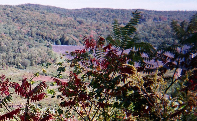
In the lower left corner of the photo is the gray bridge abutment that allowed access from the "Old" Worthington Road to Knightville across the river. Usually this is filled with water but 2010 has been a drought year. Knightville cemetery was on the shore immediately above the other side of this bridge abutment
Note: Marker transcription, relationship links, picture of marker and any additional information are posted at Norwich Bridge Cemetery. A link to each memorial in Norwich Bridge Cemetery is included. For those few instances where the remains actually were moved, the only memorial is in Norwich Bridge Cemetery.
The markers from Indian Hollow and Knightville Cemeteries were removed as part of a flood control project that created Knightville Reservoir in 1939-40. A burial permit was issued by the Town Clerk's Office, Huntington, MA for each marker (or person on the marker). Each permit stub has a transcription of the gravestone. Unless a family member had the remains exhumed and moved, the remains were left in place. Soil from the original grave accompanied the marker and was placed under it at its new location in Norwich Bridge Cemetery
The markers are at the top of the cemetery hill. Their location is marked with a boulder and plaque, "The graves in this back section were moved from the Knightville and Indian Hollow cemeteries due to the construction of Knightville Dam in 1939. There are 54 unknown graves."
Walter Corbin transcribed the cemetery on 22 July 1936. At that time, he found 90 legible markers.
The cemetery was located outside the center of Knightville. Elias Rude sold the ground for the cemetery for $25.00 if the village would form a cemetery association. Although the association was formed, the $25.00 never was paid so no deed was given. Families had paid for the care of their markers. The town of Huntington had paid for the upkeep since 1884. In order to clear title for eminent domain seizure, the town had to obtain the deeds from the lot owners and from the descendants of lot owners, who had purchased directly from Mr. Rude. When the town acquired all the deeds, transfer to the state had to be granted at town meeting.
In the lower left corner of the photo is the gray bridge abutment that allowed access from the "Old" Worthington Road to Knightville across the river. Usually this is filled with water but 2010 has been a drought year. Knightville cemetery was on the shore immediately above the other side of this bridge abutment
Note: Marker transcription, relationship links, picture of marker and any additional information are posted at Norwich Bridge Cemetery. A link to each memorial in Norwich Bridge Cemetery is included. For those few instances where the remains actually were moved, the only memorial is in Norwich Bridge Cemetery.
Nearby cemeteries


Cerney Wick, Cotswold District, Gloucestershire, England
- Total memorials1
- Percent photographed100%
Sekondi-Takoradi, Western, Ghana
- Total memorials69
- Percent photographed6%
- Percent with GPS0%

Cape Coast, Central, Ghana
- Total memorials6
- Percent photographed67%
- Percent with GPS0%
- Added: 14 Sep 2010
- Find a Grave Cemetery ID: 2370251

Cemetery Photos
This is a carousel with slides. Use Next and Previous buttons to navigate, or jump to a slide with the slide dots. Use Escape keyboard button or the Close button to close the carousel.
Success
Uploading...
Waiting...
Failed
This photo was not uploaded because this cemetery already has 20 photos
This photo was not uploaded because you have already uploaded 5 photos to this cemetery
This photo was not uploaded because you have already uploaded 5 photos to this cemetery
Invalid File Type
Birth and death years unknown.
1 photo picked...
2 photos picked...
Uploading 1 Photo
Uploading 2 Photos
1 Photo Uploaded
2 Photos Uploaded
Size exceeded
Too many photos have been uploaded
"Unsupported file type"
• ##count## of 0 memorials with GPS displayed. Double click on map to view more.No cemeteries found