Jump Cemetery
Polk, Polk County, Missouri, USA – *No GPS coordinates
About
-
No location information available
Add Location - Cemetery ID:
Members have Contributed
- 10 Memorials
- 60% photographed
- No location information available Add Location
Advertisement
Photos
No additional photos.
Add PhotosThis cemetery consists of only one tombstone with 7 names on it. The person who copied the inscriptions is unknown, and the date when they were copied is unknown. Information about this cemetery was obtained from Mrs. Mae Chappell on Aug 9, 1998.
------------------------------------------------------------
Thank you to Larry and Ramona Boyd who were kind enough to go out and take this photo for me.
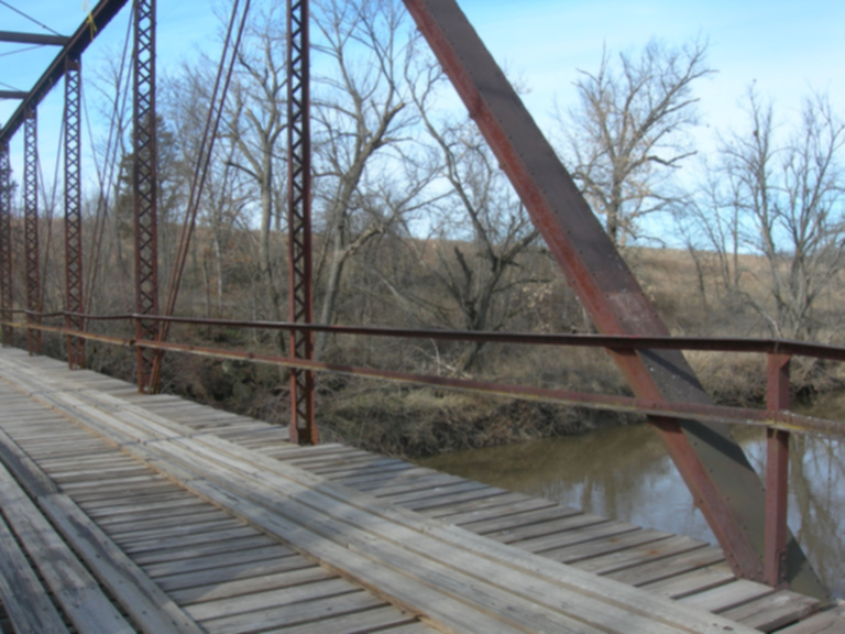
For you and a little direction of "where" John Jump may lie ... i took the picture from the east side of the bridge looking across Lindley Creek to the bluff/hill where we think he and his family were buried. our "think" is based on the Polk County Genealogical Society's map of locations of cemeteries.
From the first vertical steel railing looking across the bridge and back to the angled flat support to the edge of the picture - you see the ground horizon behind the trees. that horizon is where the land flattens out from the rise of ground from Lindley. it is atop and along that "ridge" where we believe (based on PCGS maps & directions) the original cemetery was located.
This old steel bridge was built in 1911 and is one of the few left in the county. i do not know if there was a river crossing prior to the building of this bridge - if it replaced an older river crossing or was a new one to connect Rimby and Polk towns. point being, the years between 1886 and 1911 would have been a completely different landscape and this picture is a best guess scenario based on descriptions as to where John may be interred. sometimes we think the winter is such a bad time for pictures because of the nakedness of the trees and brush ... however, for this one - it could not have been better. if all were in bloom and leafy you would not have been able to see the ground on the west side of Lindley.
2 miles north of Morrisville.
Larry Boyd
This cemetery consists of only one tombstone with 7 names on it. The person who copied the inscriptions is unknown, and the date when they were copied is unknown. Information about this cemetery was obtained from Mrs. Mae Chappell on Aug 9, 1998.
------------------------------------------------------------
Thank you to Larry and Ramona Boyd who were kind enough to go out and take this photo for me.
For you and a little direction of "where" John Jump may lie ... i took the picture from the east side of the bridge looking across Lindley Creek to the bluff/hill where we think he and his family were buried. our "think" is based on the Polk County Genealogical Society's map of locations of cemeteries.
From the first vertical steel railing looking across the bridge and back to the angled flat support to the edge of the picture - you see the ground horizon behind the trees. that horizon is where the land flattens out from the rise of ground from Lindley. it is atop and along that "ridge" where we believe (based on PCGS maps & directions) the original cemetery was located.
This old steel bridge was built in 1911 and is one of the few left in the county. i do not know if there was a river crossing prior to the building of this bridge - if it replaced an older river crossing or was a new one to connect Rimby and Polk towns. point being, the years between 1886 and 1911 would have been a completely different landscape and this picture is a best guess scenario based on descriptions as to where John may be interred. sometimes we think the winter is such a bad time for pictures because of the nakedness of the trees and brush ... however, for this one - it could not have been better. if all were in bloom and leafy you would not have been able to see the ground on the west side of Lindley.
2 miles north of Morrisville.
Larry Boyd
Nearby cemeteries

Polk, Polk County, Missouri, USA
- Total memorials1k+
- Percent photographed88%
- Percent with GPS1%

Polk, Polk County, Missouri, USA
- Total memorials899
- Percent photographed88%
- Percent with GPS1%

Polk, Polk County, Missouri, USA
- Total memorials183
- Percent photographed97%
- Percent with GPS2%

Bolivar, Polk County, Missouri, USA
- Total memorials5k+
- Percent photographed96%
- Percent with GPS1%
- Added: 7 Feb 2009
- Find a Grave Cemetery ID: 2292819

Cemetery Photos
This is a carousel with slides. Use Next and Previous buttons to navigate, or jump to a slide with the slide dots. Use Escape keyboard button or the Close button to close the carousel.
Success
Uploading...
Waiting...
Failed
This photo was not uploaded because this cemetery already has 20 photos
This photo was not uploaded because you have already uploaded 5 photos to this cemetery
This photo was not uploaded because you have already uploaded 5 photos to this cemetery
Invalid File Type
Birth and death years unknown.
1 photo picked...
2 photos picked...
Uploading 1 Photo
Uploading 2 Photos
1 Photo Uploaded
2 Photos Uploaded
Size exceeded
Too many photos have been uploaded
"Unsupported file type"
• ##count## of 0 memorials with GPS displayed. Double click on map to view more.No cemeteries found