St. Chad Churchyard
Wybunbury, Cheshire East Unitary Authority, Cheshire, England
About
-
Get directions Main Road
Wybunbury, Cheshire East Unitary Authority, Cheshire CW5 7NA EnglandCoordinates: 53.04528, -2.44885 - Cemetery ID:
Members have Contributed
Advertisement
Photos


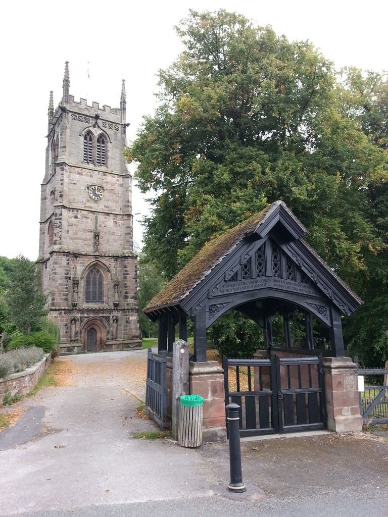
In the early 1790s the church was repaired or rebuilt. However, this did not last long and in 1832 Staffordshire engineer James Trubshaw was contracted to build the third major stone church on the site. In 1833 the body of the church was demolished but Trubshaw was successful in straightening the tower before rebuilding the body of the church in a style loosely based on the previous building. The techniques used to straighten the tower proved so successful that the same principles were used to help partially straighten the leaning Tower of Pisa (1990-2001).
Whilst the tower has survived for over 500 years, during this time, due to unstable ground beneath it, five churches have become unsafe and have had to be rebuilt. The foundation stone of the last church was laid in April 1892. The design was low and narrow and intended to replicate the previous church, A third of the building costs were spent on foundations, leaving very little money to spend on the decoration of the exterior of the church. It was hoped that the solid foundations would overcome the previous problems of sinking.
It soon became clear that ground movement had once again taken its toll and less than 80 years after it was built the church began to sink again. After much consultation it was felt that the costs were too great to bear and the church was closed after the services for Christmas 1972 and was demolished in 1977. A new church has subsequently been built further into town, just under a quarter of a mile from this site.
The Tower was saved from demolition by a group of villagers who formed the Wybunbury Tower Preservation Trust. It is now recorded in the National Heritage List for England as a designated Grade II Listed Building.
The churchyard is full, and on the site there is a very useful plan of the graves together with a list of those buried there. Across the road is an extension to the churchyard, where it appears burials started in the early1900s.
Nearby cemeteries

Weston, Cheshire East Unitary Authority, Cheshire, England
- Total memorials817
- Percent photographed99%
- Percent with GPS0%

Wistaston, Cheshire East Unitary Authority, Cheshire, England
- Total memorials2k+
- Percent photographed100%
- Percent with GPS2%
Nantwich, Cheshire East Unitary Authority, Cheshire, England
- Total memorials1
- Percent photographed0%
- Percent with GPS0%

Nantwich, Cheshire East Unitary Authority, Cheshire, England
- Total memorials1
- Percent photographed0%
- Added: 18 Feb 2007
- Find a Grave Cemetery ID: 2207336

Cemetery Photos
This is a carousel with slides. Use Next and Previous buttons to navigate, or jump to a slide with the slide dots. Use Escape keyboard button or the Close button to close the carousel.


Success
Uploading...
Waiting...
Failed
This photo was not uploaded because this cemetery already has 20 photos
This photo was not uploaded because you have already uploaded 5 photos to this cemetery
This photo was not uploaded because you have already uploaded 5 photos to this cemetery
Invalid File Type
Birth and death years unknown.
1 photo picked...
2 photos picked...
Uploading 1 Photo
Uploading 2 Photos
1 Photo Uploaded
2 Photos Uploaded
Size exceeded
Too many photos have been uploaded
"Unsupported file type"
• ##count## of 0 memorials with GPS displayed. Double click on map to view more.No cemeteries found