Shoemaker Graveyard
Lurgan Township, Franklin County, Pennsylvania, USA
About
-
Get directions Otterbein School Road
Lurgan Township, Pennsylvania 17240 United StatesCoordinates: 40.13073, -77.62365 - Cemetery ID:
Members have Contributed
Advertisement
Photos


"Shoemaker Graveyard
Shoemaker Graveyard lies at the foot of the Blue Mountain and north of Route 641 about midway between Newburg and Roxbury.
It is found by turning north off Route 641 onto Otterbein School Road 618, the second road (dirt) west of the Otterbein United Methodist Church Cemetery. About a mile up the dirt road [road is now paved, 2012], a lane leads east across a run, west branch of Clippinger's Run, to a house and barn which are the second buildings up this road. The graveyard is about a city block east on out the farm lane on the south side. The buildings mentioned and farm belong to John Calvin Negley and his wife Leota.
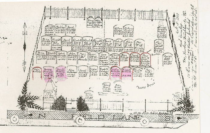
The graveyard is 63' wide by 86' long. Its length adjoins the lane leading to it. A well built iron fence about four feet high encloses the yard which is entered from the lane through a gate near the east end of the north side.
Burials were made in this family graveyard from about 1800 to 1900. A high per cent of the graves in this carefully planned yard were originally marked by headstones that stood in straight even lengthwise rows. Today (1975) this graveyard is now abandoned.
On Nov. 29, 1965, I copied the inscriptions as I have listed them here, starting with the first row on the north side at the gate and working from west to east in each row. The stones were nearly all standing then and were fairly easy to read. As a help to researchers, I have written the last name first and heading phrases, such as "In memory of," have been omitted; otherwise the full information is unaltered. Each stone is a separate entity in print."
Cemetery is on PRIVATE PROPERTY in the middle of a farm field. Some of the landmarks mentioned above have changed. A photo of the cemetery is also in the book.
"Shoemaker Graveyard
Shoemaker Graveyard lies at the foot of the Blue Mountain and north of Route 641 about midway between Newburg and Roxbury.
It is found by turning north off Route 641 onto Otterbein School Road 618, the second road (dirt) west of the Otterbein United Methodist Church Cemetery. About a mile up the dirt road [road is now paved, 2012], a lane leads east across a run, west branch of Clippinger's Run, to a house and barn which are the second buildings up this road. The graveyard is about a city block east on out the farm lane on the south side. The buildings mentioned and farm belong to John Calvin Negley and his wife Leota.
The graveyard is 63' wide by 86' long. Its length adjoins the lane leading to it. A well built iron fence about four feet high encloses the yard which is entered from the lane through a gate near the east end of the north side.
Burials were made in this family graveyard from about 1800 to 1900. A high per cent of the graves in this carefully planned yard were originally marked by headstones that stood in straight even lengthwise rows. Today (1975) this graveyard is now abandoned.
On Nov. 29, 1965, I copied the inscriptions as I have listed them here, starting with the first row on the north side at the gate and working from west to east in each row. The stones were nearly all standing then and were fairly easy to read. As a help to researchers, I have written the last name first and heading phrases, such as "In memory of," have been omitted; otherwise the full information is unaltered. Each stone is a separate entity in print."
Cemetery is on PRIVATE PROPERTY in the middle of a farm field. Some of the landmarks mentioned above have changed. A photo of the cemetery is also in the book.
Nearby cemeteries

Otterbein, Franklin County, Pennsylvania, USA
- Total memorials1k+
- Percent photographed87%
- Percent with GPS6%

Otterbein, Franklin County, Pennsylvania, USA
- Total memorials51
- Percent photographed96%
- Percent with GPS6%

Hopewell Township, Cumberland County, Pennsylvania, USA
- Total memorials42
- Percent photographed71%
- Percent with GPS10%

Roxbury, Franklin County, Pennsylvania, USA
- Total memorials412
- Percent photographed85%
- Percent with GPS0%
- Added: 13 Jan 2012
- Find a Grave Cemetery ID: 2433421

Cemetery Photos
This is a carousel with slides. Use Next and Previous buttons to navigate, or jump to a slide with the slide dots. Use Escape keyboard button or the Close button to close the carousel.


Success
Uploading...
Waiting...
Failed
This photo was not uploaded because this cemetery already has 20 photos
This photo was not uploaded because you have already uploaded 5 photos to this cemetery
This photo was not uploaded because you have already uploaded 5 photos to this cemetery
Invalid File Type
Birth and death years unknown.
1 photo picked...
2 photos picked...
Uploading 1 Photo
Uploading 2 Photos
1 Photo Uploaded
2 Photos Uploaded
Size exceeded
Too many photos have been uploaded
"Unsupported file type"
• ##count## of 0 memorials with GPS displayed. Double click on map to view more.No cemeteries found