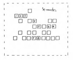
Plot number corresponds to the map as recorded in the canvass and survey from the American Indian Institute; "Our People And Where They Rest," (OPAWTR) James W. Tyner and Alice Tyner Timmons, American Indian Institute, University of Oklahoma, Norman, OK. 1971 (Library of Congress No. QE99-C5-T97) *(SEE: qualifications as to his plat map, as stated by Tyner) Volume 4, p. 107.
Their information (including any diagrams or maps) is given here as a historical reference and is presented "as is." Their book, like many such cemetery listing compilations, may contain errors. As with any genealogy information, this is merely a "source" and should be considered as such. It falls upon the end-user to verify the accuracy. See their map for use as a quick locator tool for graves here. Book is available at many Oklahoma libraries; once freely available for online viewing, the OPAWTR volumes can now be accessed only at a LDS Family History Library, a partner library, or a Family History Center. (LDS)
Keep in mind that this survey was done circa 1970, and based on a visual assessment. Thousands of important historical records are lost to today's researchers due to the fact that there are those who won't put them up on such sites as FAG - unless the marker can be found today; ignoring the fact that tornadoes, theft or removal, vandalism, damage from unrestrained farm animals, desecration due to agricultural development/usage/abuse and other such factors, (including re-internment at a different cemetery) may well have intervened over the years, and the marker the entry relied upon may indeed not be found today. Nevertheless, the value of submitting this memorial as a historical record is relevant and important to those who are tracing their ancestry.
Advertisement
Explore more
Sponsored by Ancestry
Advertisement


