Buxton Cemetery
Also known as Rhode Island Historical Cemetery North Smithfield #2
North Smithfield, Providence County, Rhode Island, USA
About
-
Get directions behind 489 Buxton St.
North Smithfield, Rhode Island 02896 United StatesCoordinates: 42.00895, -71.60417 - Cemetery ID:
Members have Contributed
Advertisement
Photos


Location: 600 ft north of BUXTON STREET at TEL pole # 42
5 burials with 2 inscriptions from 1813 to 1874
25 ft x 25 ft in poor condition no enclosure; sign in good condition
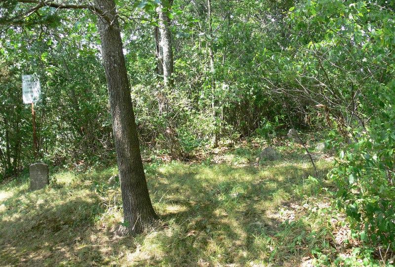
NOTE: Cemetery was first surveyed by Irene Nebiker in the early 1970's. She described location as Buxton Street Tree Farm. Roger Beaudry surveyed on October 28, 1994. At that time the cemetery stood at the edge of a corn field, adjacent to a stone wall. The sign was in excellent condition and was fortunately visible from the road. The cemetery is totally overgrown with trees, brush and weeds. The stone wall has collapsed in some places and fallen into the cemetery. Only two legible stones and 3 field stones were found. The borders of the cemetery are impossible to determine, therefore the use of 25' X 25' was used only because this is the area in which the visible stones were found.
Transcribed by Ron Farrar circa 1970. "Cider Mill Road, Tice's Place."
The above info is from:
http://ricemeteries.tripod.com/ns_ceme.HTM#NS002
August 3, 2010 - update added
The cemetery is located behind 489 Buxton St.
To get to it one must cross the back yard, over a stone wall and more yard. You could also get there by following the edge of the corn field.
The owner has been cleaning the cemetery a little and the first half is clear with just a few small trees. The historical sign designating it as NS002 is still there but is not visible from the road.
Two legible headstones in place, one legible foot stone lying along the wall and several stubs of headstones are visible.
When facing the cemetery, there is a fallen stone wall on the right and a corn field on the left.
Location: 600 ft north of BUXTON STREET at TEL pole # 42
5 burials with 2 inscriptions from 1813 to 1874
25 ft x 25 ft in poor condition no enclosure; sign in good condition
NOTE: Cemetery was first surveyed by Irene Nebiker in the early 1970's. She described location as Buxton Street Tree Farm. Roger Beaudry surveyed on October 28, 1994. At that time the cemetery stood at the edge of a corn field, adjacent to a stone wall. The sign was in excellent condition and was fortunately visible from the road. The cemetery is totally overgrown with trees, brush and weeds. The stone wall has collapsed in some places and fallen into the cemetery. Only two legible stones and 3 field stones were found. The borders of the cemetery are impossible to determine, therefore the use of 25' X 25' was used only because this is the area in which the visible stones were found.
Transcribed by Ron Farrar circa 1970. "Cider Mill Road, Tice's Place."
The above info is from:
http://ricemeteries.tripod.com/ns_ceme.HTM#NS002
August 3, 2010 - update added
The cemetery is located behind 489 Buxton St.
To get to it one must cross the back yard, over a stone wall and more yard. You could also get there by following the edge of the corn field.
The owner has been cleaning the cemetery a little and the first half is clear with just a few small trees. The historical sign designating it as NS002 is still there but is not visible from the road.
Two legible headstones in place, one legible foot stone lying along the wall and several stubs of headstones are visible.
When facing the cemetery, there is a fallen stone wall on the right and a corn field on the left.
Nearby cemeteries
Burrillville, Providence County, Rhode Island, USA
- Total memorials19
- Percent photographed47%
- Percent with GPS0%
Burrillville, Providence County, Rhode Island, USA
- Total memorials5
- Percent photographed0%
- Percent with GPS0%
Burrillville, Providence County, Rhode Island, USA
- Total memorials0
- Percent photographed0%
- Percent with GPS0%

Uxbridge, Worcester County, Massachusetts, USA
- Total memorials3
- Percent photographed67%
- Percent with GPS33%
- Added: 3 Aug 2010
- Find a Grave Cemetery ID: 2364633

Cemetery Photos
This is a carousel with slides. Use Next and Previous buttons to navigate, or jump to a slide with the slide dots. Use Escape keyboard button or the Close button to close the carousel.


Success
Uploading...
Waiting...
Failed
This photo was not uploaded because this cemetery already has 20 photos
This photo was not uploaded because you have already uploaded 5 photos to this cemetery
This photo was not uploaded because you have already uploaded 5 photos to this cemetery
Invalid File Type
Birth and death years unknown.
1 photo picked...
2 photos picked...
Uploading 1 Photo
Uploading 2 Photos
1 Photo Uploaded
2 Photos Uploaded
Size exceeded
Too many photos have been uploaded
"Unsupported file type"
• ##count## of 0 memorials with GPS displayed. Double click on map to view more.No cemeteries found