Leabank Cemetery
Also known as Lea Bank Cemetery , St Peter's Lutheran Cemetery
Rosenort, Pembina Valley Census Division, Manitoba, Canada
About
-
Get directions 00500 Provincial Range Road 33N
Rosenort, RM of Morris, Manitoba
R0G 1W0 CanadaCoordinates: 49.48750, -97.47071 - www.mhs.mb.ca/docs/sites/leabankcemetery.shtml
- [email protected]
- +1-204-736-4216
-
Office Address
St Paul's Lutheran Parish Office
14 MB-305
Brunkild, RM of MacDonald, Manitoba
R0G 0E0 Canada - Cemetery ID:
-
Additional information
Located northwest of the town of Rosenort, MB, on the south side of Provincial Range Road 33N, about 0.5 miles (0.8 km) west of the Meridian Road
There is no network of roadways providing vehicular access to the grounds.
Burial records can be consulted by reaching out to the Parish Secretary.
Members have Contributed
Advertisement
Photos

Seven persons met at the home of Mrs. Emily Amenda on December 12, 1939, to organize a Women's Club. It was moved and carried that they call the organization "The Lea-Bank Community Club".
In June 1965, a 25th Anniversary Reunion was held, with about 35 members, former members, and guests present. By 1974, there were so few members left in the club that it was decided to close the books and not have any more meetings.
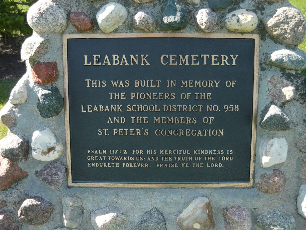
With the funds that were left and donations from people who were interested in the Lea-Bank cemetery, a cairn was erected in 1976. This was directed to the memory of all the pioneers buried there.
(Source: Furrows in the Valley - A Centennial Project of the Rural Municipality of Morris 1880 - 1980, p 765 [Adapted])
A monument in this cemetery in the Rural Municipality of Morris commemorates the members of St. Peter's congregation and the pioneers of the Leabank School district.
(Source: Manitoba Historical Society [Adapted])
Dominion Land Survey coordinates: LSD14-13-06-01-W1
In the Rural Municipality of Morris
As noted above, a part of the area's story and those of its inhabitants from the early days of European settlement through roughly 1980 is told in the volume "Furrows in the Valley - A Centennial Project of the Rural Municipality of Morris 1880 - 1980", especially starting on page 764. A free digital version of this and many other Manitoba local history books can be found online in the University of Manitoba Digital Collections. There is also a list of such books organized by district and town name on the Manitoba Historical Society's website on their page entitled "Finding Aid: Manitoba Local History Books".
A list of burials in this cemetery is available from the Manitoba Genealogical Society (reference #0489), transcribed by a member or members in 1990 and updated in 2001. Also available to MGS members is a searchable online database named the "MGS Manitoba Name Index" (or MANI). Some additional information is contained in the 1996 MGS publication "Carved in Stone: Manitoba Cemeteries and Burial Sites" (revised edition, Special Projects Publication, 106 pages).
Seven persons met at the home of Mrs. Emily Amenda on December 12, 1939, to organize a Women's Club. It was moved and carried that they call the organization "The Lea-Bank Community Club".
In June 1965, a 25th Anniversary Reunion was held, with about 35 members, former members, and guests present. By 1974, there were so few members left in the club that it was decided to close the books and not have any more meetings.
With the funds that were left and donations from people who were interested in the Lea-Bank cemetery, a cairn was erected in 1976. This was directed to the memory of all the pioneers buried there.
(Source: Furrows in the Valley - A Centennial Project of the Rural Municipality of Morris 1880 - 1980, p 765 [Adapted])
A monument in this cemetery in the Rural Municipality of Morris commemorates the members of St. Peter's congregation and the pioneers of the Leabank School district.
(Source: Manitoba Historical Society [Adapted])
Dominion Land Survey coordinates: LSD14-13-06-01-W1
In the Rural Municipality of Morris
As noted above, a part of the area's story and those of its inhabitants from the early days of European settlement through roughly 1980 is told in the volume "Furrows in the Valley - A Centennial Project of the Rural Municipality of Morris 1880 - 1980", especially starting on page 764. A free digital version of this and many other Manitoba local history books can be found online in the University of Manitoba Digital Collections. There is also a list of such books organized by district and town name on the Manitoba Historical Society's website on their page entitled "Finding Aid: Manitoba Local History Books".
A list of burials in this cemetery is available from the Manitoba Genealogical Society (reference #0489), transcribed by a member or members in 1990 and updated in 2001. Also available to MGS members is a searchable online database named the "MGS Manitoba Name Index" (or MANI). Some additional information is contained in the 1996 MGS publication "Carved in Stone: Manitoba Cemeteries and Burial Sites" (revised edition, Special Projects Publication, 106 pages).
Nearby cemeteries
Rosenort, Pembina Valley Census Division, Manitoba, Canada
- Total memorials0
- Percent photographed0%
- Percent with GPS0%

Rosenort, Pembina Valley Census Division, Manitoba, Canada
- Total memorials193
- Percent photographed92%
- Percent with GPS0%

Rosenort, Pembina Valley Census Division, Manitoba, Canada
- Total memorials30
- Percent photographed90%
- Percent with GPS0%

Rosenort, Pembina Valley Census Division, Manitoba, Canada
- Total memorials469
- Percent photographed94%
- Percent with GPS0%
- Added: 21 Jan 2016
- Find a Grave Cemetery ID: 2601366

Cemetery Photos
This is a carousel with slides. Use Next and Previous buttons to navigate, or jump to a slide with the slide dots. Use Escape keyboard button or the Close button to close the carousel.

Success
Uploading...
Waiting...
Failed
This photo was not uploaded because this cemetery already has 20 photos
This photo was not uploaded because you have already uploaded 5 photos to this cemetery
This photo was not uploaded because you have already uploaded 5 photos to this cemetery
Invalid File Type
Birth and death years unknown.
1 photo picked...
2 photos picked...
Uploading 1 Photo
Uploading 2 Photos
1 Photo Uploaded
2 Photos Uploaded
Size exceeded
Too many photos have been uploaded
"Unsupported file type"
• ##count## of 0 memorials with GPS displayed. Double click on map to view more.No cemeteries found