Hilton Cemetery
Hilton, Southwestern Census Division, Manitoba, Canada
About
-
Get directions 92020 Provincial Range Road 34N
Hilton, Rural Municipality of Prairie Lakes, Manitoba
R0K 1R0 CanadaCoordinates: 49.50287, -99.54119 - www.rmofprairielakes.ca/
- [email protected]
- +1-204-537-2241
-
Office Address
Rural Municipality of Prairie Lakes
211-3rd Street S
PO Box 100
Belmont, Rural Municipality of Prairie Lakes, Manitoba
R0K 0C0 Canada - Cemetery ID:
-
Additional information
Located WSW of the community of Hilton, MB (and NE of the community of Ninette, MB), on the NW corner of the junction of Provincial Range Road 34N with Provincial Road 92W
A single minimally maintained roadway provides nominal vehicular access to the grounds
The cemetery is managed by a local committee, whose current contact information is available from the staff of the RM of Prairie Lakes [2024/02].
Members have Contributed
Advertisement


In December of 1894, approximately 2 acres of land (SE corner of SE-27-06-16-W1) was donated by John and James Scott for a cemetery in the Hilton district for a legal fee of $1.00. On March 1, 1895, Deed No. 24569 was issued to the RM of Argyle for $25. In May of 1906, the RM of Strathcona was incorporated, comprising of Ranges 15 and 16 W1, Townships 3,4,5, and 6. It was not until November of 1977 that Deed No. 145340 was issued transferring the cemetery to the RM of Strathcona.
In 1974, the community started a Perpetual Care Fund and great interest was shown and support given by former residents and people of the district. In 1982 Peter Watson supplied and supervised the planting of 160 Scotch Pine trees around the cemetery which has greatly improved its appearance. People coming back to the cemetery from near and far have made many comments on the way it is maintained.
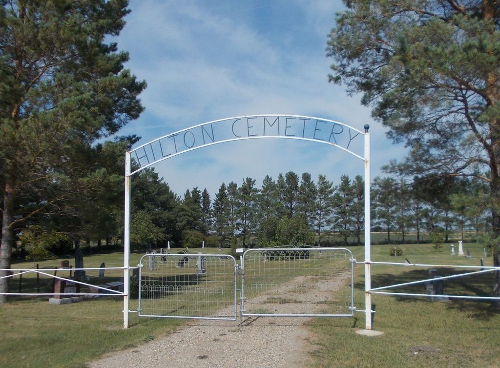
In 1983 an iron fence was put up on two sides and a sign was erected above the gate by volunteers. Some of the ladies followed up with a good paint job. Ab Little was secretary-treasurer of the Cemetery Board from 1949 to 1986, some 37 years.
(Source: Hilton Heritage, p 68 [1987; Adapted])
This cemetery is situated about a kilometre (0.6 miles) west of the village. It is on land that was donated by John and James Scott in 1894. The rows of Scotch Pines were planted in 1982.
(Source: Rural Municipality of Prairie Lakes website, Self-guided tour #2 [2024/02; Adapted])
~~~~~~~~~~
Established in 1895.
(Source: Manitoba Genealogical Society)
~~~~~~~~~~
Dominion Land Survey coordinates: LSD01-27-06-16-W1
In the Rural Municipality of Prairie Lakes
~~~~~~~~~~
As noted above, a part of the community's story, and those of its inhabitants, from the early days of European settlement through roughly 1987 is told in the volume "Hilton Heritage".
NOTE: The related local history book entitled "Municipality of Strathcona - A Snapshot in Time", published in 2009, contains a list of burials on pp 899ff known to the authors at that time.
Free digital versions of these and many other Manitoba local history books can be found online in the University of Manitoba Digital Collections. There is also a list of such books organized by district and town name on the Manitoba Historical Society's website on their page entitled "Finding Aid: Manitoba Local History Books".
A list of burials in this cemetery is available from the Manitoba Genealogical Society (reference #0558), transcribed by a member or members in 1990. Also available to MGS members is a searchable online database named the "MGS Manitoba Name Index" (or MANI). Some additional information is contained in the 1996 MGS publication "Carved in Stone: Manitoba Cemeteries and Burial Sites" (revised edition, Special Projects Publication, 106 pages).
In December of 1894, approximately 2 acres of land (SE corner of SE-27-06-16-W1) was donated by John and James Scott for a cemetery in the Hilton district for a legal fee of $1.00. On March 1, 1895, Deed No. 24569 was issued to the RM of Argyle for $25. In May of 1906, the RM of Strathcona was incorporated, comprising of Ranges 15 and 16 W1, Townships 3,4,5, and 6. It was not until November of 1977 that Deed No. 145340 was issued transferring the cemetery to the RM of Strathcona.
In 1974, the community started a Perpetual Care Fund and great interest was shown and support given by former residents and people of the district. In 1982 Peter Watson supplied and supervised the planting of 160 Scotch Pine trees around the cemetery which has greatly improved its appearance. People coming back to the cemetery from near and far have made many comments on the way it is maintained.
In 1983 an iron fence was put up on two sides and a sign was erected above the gate by volunteers. Some of the ladies followed up with a good paint job. Ab Little was secretary-treasurer of the Cemetery Board from 1949 to 1986, some 37 years.
(Source: Hilton Heritage, p 68 [1987; Adapted])
This cemetery is situated about a kilometre (0.6 miles) west of the village. It is on land that was donated by John and James Scott in 1894. The rows of Scotch Pines were planted in 1982.
(Source: Rural Municipality of Prairie Lakes website, Self-guided tour #2 [2024/02; Adapted])
~~~~~~~~~~
Established in 1895.
(Source: Manitoba Genealogical Society)
~~~~~~~~~~
Dominion Land Survey coordinates: LSD01-27-06-16-W1
In the Rural Municipality of Prairie Lakes
~~~~~~~~~~
As noted above, a part of the community's story, and those of its inhabitants, from the early days of European settlement through roughly 1987 is told in the volume "Hilton Heritage".
NOTE: The related local history book entitled "Municipality of Strathcona - A Snapshot in Time", published in 2009, contains a list of burials on pp 899ff known to the authors at that time.
Free digital versions of these and many other Manitoba local history books can be found online in the University of Manitoba Digital Collections. There is also a list of such books organized by district and town name on the Manitoba Historical Society's website on their page entitled "Finding Aid: Manitoba Local History Books".
A list of burials in this cemetery is available from the Manitoba Genealogical Society (reference #0558), transcribed by a member or members in 1990. Also available to MGS members is a searchable online database named the "MGS Manitoba Name Index" (or MANI). Some additional information is contained in the 1996 MGS publication "Carved in Stone: Manitoba Cemeteries and Burial Sites" (revised edition, Special Projects Publication, 106 pages).
Nearby cemeteries

Belmont, Southwestern Census Division, Manitoba, Canada
- Total memorials1k+
- Percent photographed80%
- Percent with GPS0%

Treesbank, Brandon Census Division, Manitoba, Canada
- Total memorials427
- Percent photographed95%
- Percent with GPS3%

Wawanesa, Brandon Census Division, Manitoba, Canada
- Total memorials824
- Percent photographed99%
- Percent with GPS3%

Ninette, Southwestern Census Division, Manitoba, Canada
- Total memorials590
- Percent photographed89%
- Percent with GPS3%
- Added: 25 Aug 2014
- Find a Grave Cemetery ID: 2551632

Cemetery Photos
This is a carousel with slides. Use Next and Previous buttons to navigate, or jump to a slide with the slide dots. Use Escape keyboard button or the Close button to close the carousel.


Success
Uploading...
Waiting...
Failed
This photo was not uploaded because this cemetery already has 20 photos
This photo was not uploaded because you have already uploaded 5 photos to this cemetery
This photo was not uploaded because you have already uploaded 5 photos to this cemetery
Invalid File Type
Birth and death years unknown.
1 photo picked...
2 photos picked...
Uploading 1 Photo
Uploading 2 Photos
1 Photo Uploaded
2 Photos Uploaded
Size exceeded
Too many photos have been uploaded
"Unsupported file type"
• ##count## of 0 memorials with GPS displayed. Double click on map to view more.No cemeteries found