Bailey Cemetery #1
Punkin Center, Howard County, Missouri, USA – *No GPS coordinates
About
-
No location information available
Add Location - Cemetery ID:
Members have Contributed
- 11 Memorials
- 100% photographed
- No location information available Add Location
Advertisement
Photos


HOWARD CO., MO MAPS OF RURAL CEMETERIES
BAILEY CEMETERY
T 51 R 14. S 21
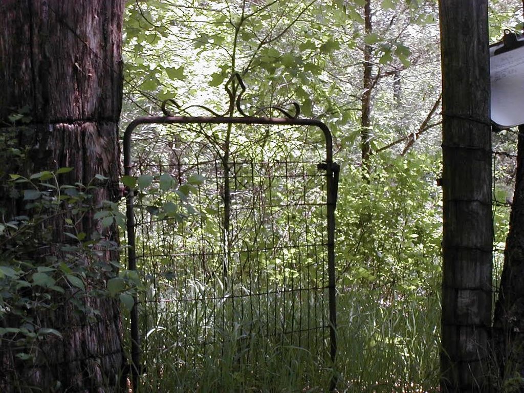
County Road A at top of hill in area where coal mining operation was carried out. Farm formerly owned by Ed St. Clair and wife Nancy, who was daughter of Minter Sr. and Nancy Bailey. Land now owned by American Minerals, Inc. Good Fence. Top blew out of cedar tree. Cemetery needs work. A few years ago new stones were placed, but some were without dates.
Cemetery established on farm of Minter Bailey, may be next to his log cabin. Is within 2 to 3 miles of the Mount Pleasant Christian Church and Cemetery.
Two nearby Bailey graveyards have been destroyed, burial records not found:
*********************
BAILEY CEMETERY #2
T 51 R 14 S 16
Route A on Clabe Dougherty farm. DESTROYED. No further information available.
*********************
BAILEY CEMETERY #3
T 51 R 14 S 10
County Road Y on Earl Faucht farm. DESTROYED. No further information available.
A neighbor removed all of the tombstones from the three Bailey cemeteries (and possibly others), except the Minter Sr and Nancy Bailey stone, to build foundation for his farm buildings, which has made it impossible to locate the two "lost" Bailey cemeteries.
HOWARD CO., MO MAPS OF RURAL CEMETERIES
BAILEY CEMETERY
T 51 R 14. S 21
County Road A at top of hill in area where coal mining operation was carried out. Farm formerly owned by Ed St. Clair and wife Nancy, who was daughter of Minter Sr. and Nancy Bailey. Land now owned by American Minerals, Inc. Good Fence. Top blew out of cedar tree. Cemetery needs work. A few years ago new stones were placed, but some were without dates.
Cemetery established on farm of Minter Bailey, may be next to his log cabin. Is within 2 to 3 miles of the Mount Pleasant Christian Church and Cemetery.
Two nearby Bailey graveyards have been destroyed, burial records not found:
*********************
BAILEY CEMETERY #2
T 51 R 14 S 16
Route A on Clabe Dougherty farm. DESTROYED. No further information available.
*********************
BAILEY CEMETERY #3
T 51 R 14 S 10
County Road Y on Earl Faucht farm. DESTROYED. No further information available.
A neighbor removed all of the tombstones from the three Bailey cemeteries (and possibly others), except the Minter Sr and Nancy Bailey stone, to build foundation for his farm buildings, which has made it impossible to locate the two "lost" Bailey cemeteries.
Nearby cemeteries

Punkin Center, Howard County, Missouri, USA
- Total memorials311
- Percent photographed94%
- Percent with GPS0%

Fayette, Howard County, Missouri, USA
- Total memorials4k+
- Percent photographed65%
- Percent with GPS6%

Glasgow, Howard County, Missouri, USA
- Total memorials3k+
- Percent photographed68%
- Percent with GPS5%

New Franklin, Howard County, Missouri, USA
- Total memorials2k+
- Percent photographed90%
- Percent with GPS85%
- Added: 13 Jan 2014
- Find a Grave Cemetery ID: 2526751

Cemetery Photos
This is a carousel with slides. Use Next and Previous buttons to navigate, or jump to a slide with the slide dots. Use Escape keyboard button or the Close button to close the carousel.


Success
Uploading...
Waiting...
Failed
This photo was not uploaded because this cemetery already has 20 photos
This photo was not uploaded because you have already uploaded 5 photos to this cemetery
This photo was not uploaded because you have already uploaded 5 photos to this cemetery
Invalid File Type
Birth and death years unknown.
1 photo picked...
2 photos picked...
Uploading 1 Photo
Uploading 2 Photos
1 Photo Uploaded
2 Photos Uploaded
Size exceeded
Too many photos have been uploaded
"Unsupported file type"
• ##count## of 0 memorials with GPS displayed. Double click on map to view more.No cemeteries found