Gale Family Cemetery
Winhall, Bennington County, Vermont, USA
About
-
Get directions Winhall Hollow Rd
Winhall, Vermont 05340 United StatesCoordinates: 43.17071, -72.87641 - Cemetery ID:
Members have Contributed
Advertisement
Photos
No additional photos.
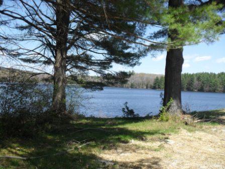
Add PhotosGale Meadows WMA is open to regulated hunting, trapping, fishing, hiking and wildlife viewing. Several miles of stonewalls and the 200-year old farmhouse and barn are evidence that the lands of Gale Meadows WMA were used for agricultural purposes for several generations. The land began to revert back to forest in the late 1800s when farming activities ceased.
Gale Meadows takes its name from Levi and Horace Gale, who acquired the property in 1827. They divided the land between themselves by means of an unwritten agreement. It is generally assumed that Levi constructed the home and barn for his wife and eight children. The farm remained in the Gale family through the late 1920s. Between the late 1920's and 1945, the farm had several owners. At one time, it even served as a boy's camp known as Hexonia. In 1945 Henry and Alice Green purchased the buildings and some acreage from a Boston physician, who was using the house as a hunting camp. The Greens affectionately named the property Tralee, and over a 20- year period acquired adjacent lands totaling approximately 485 acres. The Greens were instrumental in the creation of the pond in 1964. They donated land and procured additional land 50 feet above the proposed water level. Nine other landowners and the Vermont Fish & Wildlife Department also contributed to the pond-building project. In 1993, the Greens placed conservation easements on 194 acres of their land and deeded an additional 181 acres to the Vermont Fish & Wildlife Department. Land around the perimeter of the pond was secured as a natural and undisturbed riparian zone with the help of the Vermont Housing and Conservation Board and the Vermont Land Trust. The Vermont Fish & Wildlife Department inherited the remainder of the Greens' landholdings in 1996. The Greens' legacy left 707 conserved acres, the third largest water body in southern Vermont, and 95% of the shoreline in public ownership.
Gale Meadows WMA is open to regulated hunting, trapping, fishing, hiking and wildlife viewing. Several miles of stonewalls and the 200-year old farmhouse and barn are evidence that the lands of Gale Meadows WMA were used for agricultural purposes for several generations. The land began to revert back to forest in the late 1800s when farming activities ceased.
Gale Meadows takes its name from Levi and Horace Gale, who acquired the property in 1827. They divided the land between themselves by means of an unwritten agreement. It is generally assumed that Levi constructed the home and barn for his wife and eight children. The farm remained in the Gale family through the late 1920s. Between the late 1920's and 1945, the farm had several owners. At one time, it even served as a boy's camp known as Hexonia. In 1945 Henry and Alice Green purchased the buildings and some acreage from a Boston physician, who was using the house as a hunting camp. The Greens affectionately named the property Tralee, and over a 20- year period acquired adjacent lands totaling approximately 485 acres. The Greens were instrumental in the creation of the pond in 1964. They donated land and procured additional land 50 feet above the proposed water level. Nine other landowners and the Vermont Fish & Wildlife Department also contributed to the pond-building project. In 1993, the Greens placed conservation easements on 194 acres of their land and deeded an additional 181 acres to the Vermont Fish & Wildlife Department. Land around the perimeter of the pond was secured as a natural and undisturbed riparian zone with the help of the Vermont Housing and Conservation Board and the Vermont Land Trust. The Vermont Fish & Wildlife Department inherited the remainder of the Greens' landholdings in 1996. The Greens' legacy left 707 conserved acres, the third largest water body in southern Vermont, and 95% of the shoreline in public ownership.
Nearby cemeteries
Londonderry, Windham County, Vermont, USA
- Total memorials2
- Percent photographed0%
- Percent with GPS0%

Winhall, Bennington County, Vermont, USA
- Total memorials254
- Percent photographed98%
- Percent with GPS0%

Bondville, Bennington County, Vermont, USA
- Total memorials413
- Percent photographed92%
- Percent with GPS2%

Winhall, Bennington County, Vermont, USA
- Total memorials74
- Percent photographed86%
- Percent with GPS8%
- Added: 28 Apr 2012
- Find a Grave Cemetery ID: 2447268

Cemetery Photos
This is a carousel with slides. Use Next and Previous buttons to navigate, or jump to a slide with the slide dots. Use Escape keyboard button or the Close button to close the carousel.
Success
Uploading...
Waiting...
Failed
This photo was not uploaded because this cemetery already has 20 photos
This photo was not uploaded because you have already uploaded 5 photos to this cemetery
This photo was not uploaded because you have already uploaded 5 photos to this cemetery
Invalid File Type
Birth and death years unknown.
1 photo picked...
2 photos picked...
Uploading 1 Photo
Uploading 2 Photos
1 Photo Uploaded
2 Photos Uploaded
Size exceeded
Too many photos have been uploaded
"Unsupported file type"
• ##count## of 0 memorials with GPS displayed. Double click on map to view more.No cemeteries found