East Perth Cemeteries
Perth, City of Perth, Western Australia, Australia
About
-
- Cemetery ID:
Members have Contributed
Advertisement
Photos


The site, which is a short distance from Gloucester Park and the WACA Ground, is bound by Wittenoom, Plain and Bronte Streets and Waterloo Crescent in East Perth, Australia.
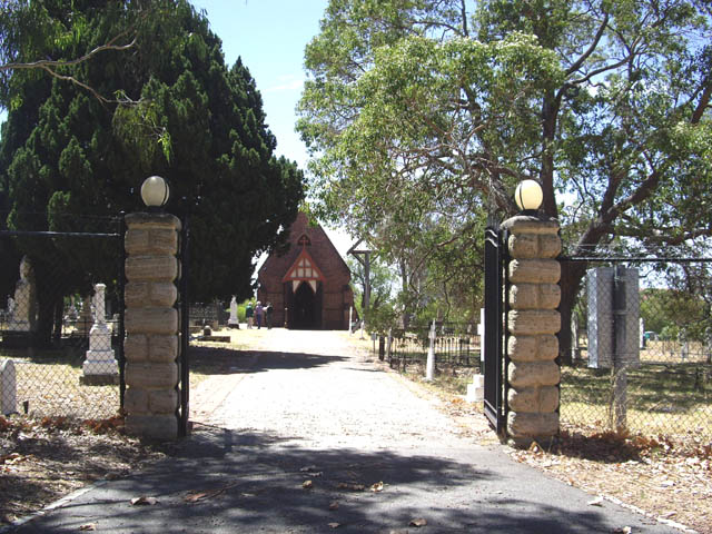
East Perth Cemetery entrance is on the northern side of Bronte Street near Waterloo Crescent.
Western Australians are fortunate to still have their historic East Perth Cemeteries as if they were in most other capital cities, they would have fallen prey to the pressures and demands of urban sprawl.
They were set aside as the main burial ground for the capital of the Swan River Colony soon after its foundation in 1829, and were not only associated with the early pioneering period, but for virtually the entire colonial period which lasted until to the end of the nineteenth century.
They are quite correctly called cemeteries as even though the site appears as one today, it originally incorporated seven individual denominational cemeteries which came into existence progressively through the latter half of nineteenth century until the time when the site was closed in 1899. Each cemetery was fenced off and in most cases was separated from the others by a public roadway.
The cemetery complex also houses St. Bartholomew's Church which served as a burial chapel and a parish church for nearby residents, and both the cemeteries and the chapel were classified by National Trust of Australia (WA) as places of cultural heritage significance and listed on the Register of the National Estate by the Australian Heritage Commission in 1978.
Apart from being the main burial ground for the capital of Western Australia since its foundation in 1829 and one of the few remaining original burial grounds in any of the Australian capital cities, National Trust identified the cemeteries as being significant at a Local, State and National level on other counts as well.
They represent aspects of the social, religious, political, economic and artistic life of the community during the nineteenth century in relation to death and burial, and demonstrate the nature of community attitudes, values and taste and the changes which occurred throughout the period.
Today's East Perth Cemeteries complex was originally made up of a group of seven cemeteries which were operated independently by various religious and ethnic organisations. Each burial ground had its own boundary fence and roads were laid out between them to give access.
The gravesites, memorials and grave surrounds are significant as historic artefacts and relics associated with nineteenth century burial customs and practices in Western Australia. They are significant for the records which are inscribed on them and as examples of the nature of nineteenth century monumental craftsmanship in Western Australia and elsewhere. The memorials are significant for their association with numerous prominent public figures and the first generations of settlers in Western Australia.
The historic trees on the site are representative of cemetery and street tree plantings in Perth in the late nineteenth century and are significant as landscape elements and as potential propagation stock.
St. Bartholomew's Church is significant for its association with the Church of England Cemetery; its age; its association with the noted colonial architect, Richard Roach Jewell; and for the community sentiment associated with the building. There is also significance at a Local and State level as part of the history of the Church of England in Western Australia.
The site occupied by the cemeteries is also significant as a prominent landscape and townscape feature and is one of the earliest public sites to have been surveyed in Perth.
Land was allocated progressively between 1842 and 1888 as various community groups grew in number.
1829: Perth's first burial ground was surveyed and gazetted.
1842: The Church of England was given control of section R1.
1848: The Roman Catholic Church was allocated sections T41 & T42.
1854: The Wesleyan and Independent (Congregational) Churches were allocated sections T40 and T39 respectively.
1867: The Hebrews were allocated section E72 and cemetery road works were carried out.
1871: The Church of England erected St Bartholomew's burial chapel in section R1.
1876: The Roman Catholic Church was allocated sections T43 & T44 for a school and church.
1881: The Presbyterian Church was allocated sections E71 & E70.
1882: The Independent (Congregational), Wesleyan and Anglican Churches were allocated extra room in T28, T28½
and T27
1888: The Chinese community was allocated the north section of E69 but used the south section as well.
1899: The cemeteries were closed and the map shows the area which had been used for burials.
1952: The site was reduced in size. Headstones from the Hebrew & Presbyterian burial grounds placed in the
closed-off roads.
Reserve 1157 comprising Lots E67, E68, E73 and E74 had been set aside for additional space. It was never used and was transferred to the Workers' Homes Board in 1924.
With the exception of the Chinese, each religious denomination managed its own cemetery. Although records were required to be kept, very few remain today, but some information about the Church of England, Roman Catholic and Wesleyan sections was uncovered by researchers in the past and was published in the landscape study and conservation plans commissioned for the site by the East Perth Redevelopment Corporation in 1991 and the National Trust in 1995.
During the nineteenth century the area was generally known as Cemetery Hill although there were in fact seven cemeteries there in the end, each being independently owned and controlled by their respective denominations. The seven groups and their date of introduction to the site were:
Church of England (1842)
Roman Catholic (1848)
Wesleyan (1854)
Congregational (Independents) (1854)
Hebrew (1867)
Presbyterian (1881)
Chinese (1888)
This cemetery is only open to the public on Sundays between 2-4pm and there is an entry fee of $10 per person, or Family group of 4, $25. Other fees apply for differing ages, groups, concessions. There are many unmarked graves and records are incomplete. The online database https://www.eastperthcemeteries.com.au/explore/burial-search.html gives additional information on some of the records, for example:cause of death, family members. It may also give a section but no actual plot numbers making it very difficult to fulfill requests.
The site, which is a short distance from Gloucester Park and the WACA Ground, is bound by Wittenoom, Plain and Bronte Streets and Waterloo Crescent in East Perth, Australia.
East Perth Cemetery entrance is on the northern side of Bronte Street near Waterloo Crescent.
Western Australians are fortunate to still have their historic East Perth Cemeteries as if they were in most other capital cities, they would have fallen prey to the pressures and demands of urban sprawl.
They were set aside as the main burial ground for the capital of the Swan River Colony soon after its foundation in 1829, and were not only associated with the early pioneering period, but for virtually the entire colonial period which lasted until to the end of the nineteenth century.
They are quite correctly called cemeteries as even though the site appears as one today, it originally incorporated seven individual denominational cemeteries which came into existence progressively through the latter half of nineteenth century until the time when the site was closed in 1899. Each cemetery was fenced off and in most cases was separated from the others by a public roadway.
The cemetery complex also houses St. Bartholomew's Church which served as a burial chapel and a parish church for nearby residents, and both the cemeteries and the chapel were classified by National Trust of Australia (WA) as places of cultural heritage significance and listed on the Register of the National Estate by the Australian Heritage Commission in 1978.
Apart from being the main burial ground for the capital of Western Australia since its foundation in 1829 and one of the few remaining original burial grounds in any of the Australian capital cities, National Trust identified the cemeteries as being significant at a Local, State and National level on other counts as well.
They represent aspects of the social, religious, political, economic and artistic life of the community during the nineteenth century in relation to death and burial, and demonstrate the nature of community attitudes, values and taste and the changes which occurred throughout the period.
Today's East Perth Cemeteries complex was originally made up of a group of seven cemeteries which were operated independently by various religious and ethnic organisations. Each burial ground had its own boundary fence and roads were laid out between them to give access.
The gravesites, memorials and grave surrounds are significant as historic artefacts and relics associated with nineteenth century burial customs and practices in Western Australia. They are significant for the records which are inscribed on them and as examples of the nature of nineteenth century monumental craftsmanship in Western Australia and elsewhere. The memorials are significant for their association with numerous prominent public figures and the first generations of settlers in Western Australia.
The historic trees on the site are representative of cemetery and street tree plantings in Perth in the late nineteenth century and are significant as landscape elements and as potential propagation stock.
St. Bartholomew's Church is significant for its association with the Church of England Cemetery; its age; its association with the noted colonial architect, Richard Roach Jewell; and for the community sentiment associated with the building. There is also significance at a Local and State level as part of the history of the Church of England in Western Australia.
The site occupied by the cemeteries is also significant as a prominent landscape and townscape feature and is one of the earliest public sites to have been surveyed in Perth.
Land was allocated progressively between 1842 and 1888 as various community groups grew in number.
1829: Perth's first burial ground was surveyed and gazetted.
1842: The Church of England was given control of section R1.
1848: The Roman Catholic Church was allocated sections T41 & T42.
1854: The Wesleyan and Independent (Congregational) Churches were allocated sections T40 and T39 respectively.
1867: The Hebrews were allocated section E72 and cemetery road works were carried out.
1871: The Church of England erected St Bartholomew's burial chapel in section R1.
1876: The Roman Catholic Church was allocated sections T43 & T44 for a school and church.
1881: The Presbyterian Church was allocated sections E71 & E70.
1882: The Independent (Congregational), Wesleyan and Anglican Churches were allocated extra room in T28, T28½
and T27
1888: The Chinese community was allocated the north section of E69 but used the south section as well.
1899: The cemeteries were closed and the map shows the area which had been used for burials.
1952: The site was reduced in size. Headstones from the Hebrew & Presbyterian burial grounds placed in the
closed-off roads.
Reserve 1157 comprising Lots E67, E68, E73 and E74 had been set aside for additional space. It was never used and was transferred to the Workers' Homes Board in 1924.
With the exception of the Chinese, each religious denomination managed its own cemetery. Although records were required to be kept, very few remain today, but some information about the Church of England, Roman Catholic and Wesleyan sections was uncovered by researchers in the past and was published in the landscape study and conservation plans commissioned for the site by the East Perth Redevelopment Corporation in 1991 and the National Trust in 1995.
During the nineteenth century the area was generally known as Cemetery Hill although there were in fact seven cemeteries there in the end, each being independently owned and controlled by their respective denominations. The seven groups and their date of introduction to the site were:
Church of England (1842)
Roman Catholic (1848)
Wesleyan (1854)
Congregational (Independents) (1854)
Hebrew (1867)
Presbyterian (1881)
Chinese (1888)
This cemetery is only open to the public on Sundays between 2-4pm and there is an entry fee of $10 per person, or Family group of 4, $25. Other fees apply for differing ages, groups, concessions. There are many unmarked graves and records are incomplete. The online database https://www.eastperthcemeteries.com.au/explore/burial-search.html gives additional information on some of the records, for example:cause of death, family members. It may also give a section but no actual plot numbers making it very difficult to fulfill requests.
Nearby cemeteries
Perth, City of Perth, Western Australia, Australia
- Total memorials2
- Percent photographed0%
- Percent with GPS0%
Maylands, Stirling City, Western Australia, Australia
- Total memorials0
- Percent photographed0%
Perth, City of Perth, Western Australia, Australia
- Total memorials1
- Percent photographed100%

Subiaco City, Western Australia, Australia
- Total memorials0
- Percent photographed0%
- Percent with GPS0%
- Added: 3 Apr 2012
- Find a Grave Cemetery ID: 2444173

Cemetery Photos
This is a carousel with slides. Use Next and Previous buttons to navigate, or jump to a slide with the slide dots. Use Escape keyboard button or the Close button to close the carousel.


Success
Uploading...
Waiting...
Failed
This photo was not uploaded because this cemetery already has 20 photos
This photo was not uploaded because you have already uploaded 5 photos to this cemetery
This photo was not uploaded because you have already uploaded 5 photos to this cemetery
Invalid File Type
Birth and death years unknown.
1 photo picked...
2 photos picked...
Uploading 1 Photo
Uploading 2 Photos
1 Photo Uploaded
2 Photos Uploaded
Size exceeded
Too many photos have been uploaded
"Unsupported file type"
• ##count## of 0 memorials with GPS displayed. Double click on map to view more.No cemeteries found