Saint Paul's Anglican Cemetery
Also known as Saint Paul's Middlechurch Cemetery
West Saint Paul, Selkirk Census Division, Manitoba, Canada
About
-
Get directions 299 Balderstone Road
Middlechurch, RM of West St Paul, Manitoba
R4A 4A5 CanadaCoordinates: 49.97988, -97.06403 - www.stpaulsmiddlechurch.com/
- [email protected]
- +1-204-339-3978
-
Office Address
St. Paul's (Middlechurch) Anglican Church
299 Balderstone Road
Middlechurch, RM of West St Paul, Manitoba
R4A 4A5 Canada - Cemetery ID:
-
Additional information
Located in the heart of Middlechurch, MB, north of the interchange between the Perimeter Highway and the extension of Main Street (aka Provincial Highway 9) from Winnipeg, just to the east of the Highway, on the north side of Balderstone Road
There is parking for the church and cemetery, but there is no vehicular access to the grounds
Burial records can be consulted by reaching out to the Parish Staff.
Members have Contributed
Advertisement
Photos


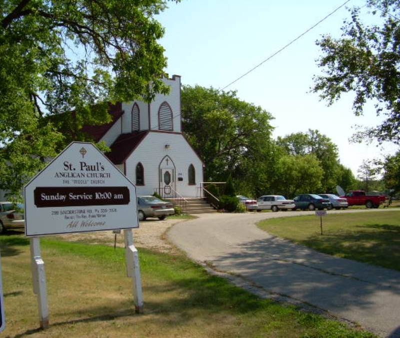
It is situated between 2 older Anglican churches - St. John's Cathedral to the south (the "lower" church relative to the bed of the nearby Red River) and St. Andrew's (on the Red; the "upper" church) to the north. Hence the name "Middlechurch" to which it is commonly referred.
There are relatively few tombstones compared to the number of burials at the cemetery. According to the church registers, it appears that a separate section was set aside for Indians - many burials here are from the Indian Residential School. Another section holds many who died at the Middlechurch Old Folks' Home from 1910 to 1930s. Few of these graves are marked. Church registers have been consulted & there is a section of the transcription noting burials from 1850-1960 where no tombstones exist.
(Source: Manitoba Genealogical Society [Adapted])
To accommodate the increasing population of the Red River Settlement in the early 19th century, Reverend David Jones of the Church Missionary Society built a second Anglican church here at Image Plain. It opened for worship on 30 January 1825, with a congregation of mixed races and faiths. Known as the "Middle Church" because of its location between St. John's and St. Andrews-on-the-Red, it was consecrated St. Paul's on 6 January 1853. Damaged by flood in 1826 and 1852, it was first replaced by a large structure in 1844, and the present edifice between 1876 and 1880. A plaque was erected next to the church in 1975 by the Historic Sites Advisory Board of Manitoba.
Lytch Gate stands on the grounds of the church. Built circa 1890, it was once used as a stopping place during funerals for the pallbearers to rest the coffin until it was time to enter the church or graveyard.
(Source: Manitoba Historical Society [Adapted])
Dominion Land Survey coordinates: LSD05-01-12-03-E1
In the Rural Municipality of West St Paul
A part of the town's story and those of its inhabitants from the early days of European settlement through roughly 1989 is told in the volume "The Changing Scene - A History of West St Paul". A free digital version of this and many other Manitoba local history books can be found online in the University of Manitoba Digital Collections. There is also a list of such books organized by district and town name on the Manitoba Historical Society's website on their page entitled "Finding Aid: Manitoba Local History Books".
A list of burials in this cemetery is available from the Manitoba Genealogical Society (reference #0083), transcribed by a member or members in 1984. Also available to MGS members is a searchable online database named the "MGS Manitoba Name Index" (or MANI). Some additional information is contained in the 1996 MGS publication "Carved in Stone: Manitoba Cemeteries and Burial Sites" (revised edition, Special Projects Publication, 106 pages).
Nearby cemeteries

West Saint Paul, Selkirk Census Division, Manitoba, Canada
- Total memorials16
- Percent photographed6%
- Percent with GPS0%

Old Kildonan, Greater Winnipeg, Manitoba, Canada
- Total memorials456
- Percent photographed13%
- Percent with GPS2%

West Saint Paul, Selkirk Census Division, Manitoba, Canada
- Total memorials1k+
- Percent photographed27%
- Percent with GPS21%

West Saint Paul, Selkirk Census Division, Manitoba, Canada
- Total memorials5k+
- Percent photographed95%
- Percent with GPS93%
- Added: 10 Jan 2010
- Find a Grave Cemetery ID: 2337558

Cemetery Photos
This is a carousel with slides. Use Next and Previous buttons to navigate, or jump to a slide with the slide dots. Use Escape keyboard button or the Close button to close the carousel.


Success
Uploading...
Waiting...
Failed
This photo was not uploaded because this cemetery already has 20 photos
This photo was not uploaded because you have already uploaded 5 photos to this cemetery
This photo was not uploaded because you have already uploaded 5 photos to this cemetery
Invalid File Type
Birth and death years unknown.
1 photo picked...
2 photos picked...
Uploading 1 Photo
Uploading 2 Photos
1 Photo Uploaded
2 Photos Uploaded
Size exceeded
Too many photos have been uploaded
"Unsupported file type"
• ##count## of 0 memorials with GPS displayed. Double click on map to view more.No cemeteries found