Fannystelle Cemetery
Also known as Sacred Heart Roman Catholic Cemetery , Cimetière catholique de la paroisse du Sacré-Coeur
Fannystelle, Portage la Prairie Census Division, Manitoba, Canada
About
-
Get directions Provincial Road 248
Fannystelle, Rural Municipality of Grey, Manitoba
R0G 0P0 CanadaCoordinates: 49.74623, -97.77828 - www.archsaintboniface.ca/parish_info.html?lang=en&p=136
- [email protected]
- +1-204-736-2847
-
Office Address
Saint-Hyacinthe Parish
27 Beaudry Street
La Salle, Manitoba
R0G 0A1 Canada - Cemetery ID:
-
Additional information
Located in the community of Fannystelle, MB, just north of Main Avenue, on the road that divides it into its East and West parts, Provincial Road 248; on the west side PR 248, just north of the junction with Church Avenue
There is no network of improved roadways providing vehicular access to the grounds.
NOTE: The parish is no longer operational. Many early records of births, marriages, and deaths were lost to various disasters through the early decades of the parish's existence
Existing parish records of burial and other events may now be consulted by contacting the St Hyacinthe Parish Secretary (La Salle, MB).
Members have Contributed
Advertisement
Photos


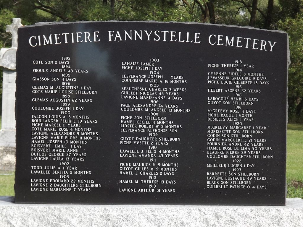
The town was named after Fanny Rives, a deceased friend of the founder of the area's early French colony in 1889, Countess Marthe d`Albufera. Created by decree of Archbishop Adélard of Saint-Boniface as the "paroisse Catholique du Sacré-Coeur de Fannystelle, Manitoba", on July 1, 1909, the area had been occupied for some time prior and burials took place in this cemetery in those early years. Many of those early burials are now marked only with a mention on a memorial wall on the grounds.
(Source: Fannystelle, [1939; Adapted and freely translated])
The first burial in this cemetery, near Fannystelle occurred in 1892.
(Source: Manitoba Historical Society [Adapted])
In 1906 the Rural Municipality of Grey was formed, separating from the northern portion of the Rural Municipality of Dufferin. The RM of Grey was named after the Governor-General of Canada at the time, Albert Henry George Grey, the fourth Earl of Grey. The first meeting was held on March 13, 1906, in Whitlam's Hall in the Village of Elm Creek.
The Municipality is made up of 10 geographic townships extending 19.2 kilometres (12 miles) from north to south and 48 kilometres (30 miles) from east to west. The original settlers in the region were mostly French-Canadian, French, and to a lesser extent of English descent. The Métis community has also had, at times, a strong influence in the community. The turn of the (twentieth) century saw a larger immigration of people from different parts of Europe. Immigrants from Belgium, the Netherlands, the Ukraine, and other Slavic countries moved in to locate on prime farmland.
(Source: Rural Municipality of Grey website [2024/02; Adapted])
~~~~~~~~~~
Dominion Land Survey coordinates: LSD08-15-09-03-W1
In the Rural Municipality of Grey
~~~~~~~~~~
A part of the community's story, and those of its inhabitants, from the early days of European settlement through roughly 1989 is told in two volumes, the first (in French) published in 1939 entitled "Fannystelle" and the second, published in 1989, entitled "Fannystelle 1889-1989".
Free digital versions of these and many other Manitoba local history books can be found online in the University of Manitoba Digital Collections. There is also a list of such books organized by district and town name on the Manitoba Historical Society's website on their page entitled "Finding Aid: Manitoba Local History Books".
A list of burials in this cemetery is available from the Manitoba Genealogical Society (reference #0723), transcribed by a member or members in NNNN and updated in NNNN. Also available to MGS members is a searchable online database named the "MGS Manitoba Name Index" (or MANI). Some additional information is contained in the 1996 MGS publication "Carved in Stone: Manitoba Cemeteries and Burial Sites" (revised edition, Special Projects Publication, 106 pages).
~~~~~~~~~~
Additionally, the South Central Regional Archives Inc. / Archives régionales Centre-Sud Inc. curates and makes available extensive records related to the communities established by the families of the area who contributed to the story of Manitoba.
Also, the St Boniface Historical Society (La Société historique de Saint-Boniface) maintains extensive records of the lives led by and influences of the people in Manitoba who had French ancestry, be it recently from France and Belgium, or by way of Quebec.
Nearby cemeteries
Whitehorse Plains Census Division, Manitoba, Canada
- Total memorials0
- Percent photographed0%
- Percent with GPS0%

Starbuck, Whitehorse Plains Census Division, Manitoba, Canada
- Total memorials571
- Percent photographed96%
- Percent with GPS0%

Elie, Whitehorse Plains Census Division, Manitoba, Canada
- Total memorials7
- Percent photographed100%
- Percent with GPS0%

Starbuck, Whitehorse Plains Census Division, Manitoba, Canada
- Total memorials102
- Percent photographed95%
- Percent with GPS1%
- Added: 30 Jul 2008
- Find a Grave Cemetery ID: 2270429

Cemetery Photos
This is a carousel with slides. Use Next and Previous buttons to navigate, or jump to a slide with the slide dots. Use Escape keyboard button or the Close button to close the carousel.


Success
Uploading...
Waiting...
Failed
This photo was not uploaded because this cemetery already has 20 photos
This photo was not uploaded because you have already uploaded 5 photos to this cemetery
This photo was not uploaded because you have already uploaded 5 photos to this cemetery
Invalid File Type
Birth and death years unknown.
1 photo picked...
2 photos picked...
Uploading 1 Photo
Uploading 2 Photos
1 Photo Uploaded
2 Photos Uploaded
Size exceeded
Too many photos have been uploaded
"Unsupported file type"
• ##count## of 0 memorials with GPS displayed. Double click on map to view more.No cemeteries found