Oldham County Cemetery Records Preservation Group
- Member for
- 12 years 2 months 1 day
- Find a Grave ID
Bio
The Cemeteries and many of the people that have made Oldham County History are listed on this web page.
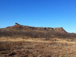
Oldham County's history has revolved around the Canadian River, which runs in an east-west direction across the northern part of the county. Excavations of Saddleback Mesa, just south of present day Cal Farley's Boys Ranch, have unearthed evidence of the Panhandle Pueblo culture. Petroglyphs and other artifacts attest to the presence of other pre-Columbian people. Plains Apaches, followed by the warlike Comanche and Kiowa, found refuge and water in the breaks of the Canadian River Valley. Various Spanish entradas utilized the river as they traveled eastward from New Mexico. The expedition of Francisco Vázquez de Coronado (1541–44), the Oñate expedition (1601), the expedition of Pedro Vial (1786-1788) and the Racundo Melgares party (1806) all passed through the area. Likewise, the Ciboleros and Comancheros from northern New Mexico all used the Canadian River Valley as a major trade route, with the Plaza Atascosa next to the Atascosa Springs in Oldham County being a frequent trading ground. Stephen H. Long, Josiah Gregg, James W. Abert, Randolph B. Marcy, and W. W. Whipple led their path finding expeditions along the Canadian River running through the area during the early nineteenth century. Buffalo hunters established temporary camps in the area in the 1870s, and they were soon joined by ranchers and pastores. By 1875 Tascosa, originally called Plaza Atascosa, was a village located just north of the Canadian River in the north central part of the county. As one of only three towns in the Panhandle, it developed a reputation as a rowdy and sometimes violent cow town.
Oldham County was formed in 1876 and organized in 1880, and named for Williamson Simpson Oldham, a Texas pioneer and Confederate Senator. The county has a total area of 1,501 square miles, of which 1,500 square miles is land and 1 square mile (0.05%) is water. In 1879, the 16th Texas Legislature appropriated 3,000,000 acres of land to finance a new state capitol and opened the area to homesteading. In 1882 in a special legislative session, the 17th Legislature struck a bargain with Charles B. and John V. Farwell of Chicago, Illinois, under which a syndicate led by the Farwells, with mostly British investors, agreed to build a new $3,000,000.00 Texas State Capitol and accept the 3,000,000 acres of Panhandle land in payment. The XIT Ranch (Ten Counties in Texas Ranch) was born and included Oldham County ranch land in the Canadian River Valley. The XIT Ranch operated out of divisional headquarters known as Buffalo Springs, Middle Water, Rito Blanco, Ojo Bravo, Alamositas, Escarbada, Spring Lake and Yellow House. Nearly the entire county was a part of the XIT Ranch. The county seat was originally at the town of Tascosa, which by the 1880s had grown into the second largest town in the Panhandle. By 1890 the county had five ranches, more than 30,000 cattle, and 270 residents. In 1902, the Matador Ranch acquired the 210,000 acre Alamositas Ranch Headquarters located in Oldham County. At its peak, the Matador owned 90,000 head of cattle and had title to 879,000 acres of land in parts of four Texas counties.
As the railroads came through Oldham County several new towns, ranches and farms sprang up along the rail lines. One of the first homesteaders in Oldham County, N. J. Whitfield arrived in 1899 and settled on land beside the Old Ozark Trail that ran east-west through Oldham County extending across Oklahoma, Texas and New Mexico. In 1903, Whitfield sold a 100-foot strip of land that extended across Section 90 in the southern part of the Oldham County to the Choctaw, Oklahoma, and Texas Railroad (later known as the Chicago, Rock Island & Pacific Railroad "CRI&P RR") as a right-of-way. He surveyed the area south of the right-of-way and then sold portions of land to other settlers, creating the town of Vega. To bypass the rugged Canadian River Valley the CRI&P RR ran a rail line east-west 23 miles south of the Canadian River. It ran between Amarillo and Tucumcari, New Mexico parallel to the Old Ozark Trail that superseded Route 66 and then I-40. The Fort Worth and Denver City Railway ran another rail line northwest-southeast 2 miles of west of Tascosa. It ran between Amarillo and Colorado. Both rail lines bypassed Tascosa and by 1915 Tascosa had a courthouse with almost no residents. That same year the county seat was moved 23 miles south to Vega. Vega was located beside the railroad and at the cross roads of the only east-west and north-south roads running through Oldham County. By 1915 all but 230,000 acres of the XIT Ranch had been sold off creating smaller ranches and farms throughout Oldham County which still remain today. As of the 2010 census, Oldham County's population was 2,052. The current cities and towns in Oldham County are: Adrian, Cal Farley's Boys Ranch, Vega and Wildorado. Today Oldham County is primarily ranching and farm land. The county also has some petroleum production and large wind farms. The winds created by the up and down drafts of the slopes and canyons of the Canadian River Valley help create near constant winds with the highest yearly average wind speeds in the world. These winds power large wind farms that are rapidly changing the Oldham County skyline and landscape.
BIBLIOGRAPHY: John L. McCarty, Maverick Town: The Story of Old Tascosa (Norman: University of Oklahoma Press, 1946; enlarged ed. 1968). Oldham County Historical Commission, Oldham County (Dallas: Taylor, 1981). Pauline D. and R. L. Robertson, Cowman's Country: Fifty Frontier Ranches in the Texas Panhandle, 1876–1887 (Amarillo: Paramount, 1981).
Donald R. Abbe and John Leffler
TRANSFERS, CORRECTIONS/ADDITIONS & FAMILY LINK REQUESTS: transfers, corrections/additions, & family links requests will be honored when possible. Please uses the "Edit" link at the top right corner of the memorial, then the "Suggest a correction or provide additional information" option for transfer requests, corrections/additions and family links. You can upload your pictures directly to the memorials, but PLEASE take pride on what you add. Photos should be carefully composed and submitted with the highest resolution that Find A Grave will accept.
TRANSFER REQUESTS: MUST follow Find A Grave guidelines-direct relatives and be a relative within four generations (siblings, parents, grandparents, and great-grandparents). Be specific on your relationship.
Please do not post Death Certificates on any of the memorial listed on these pages!
The Cemeteries and many of the people that have made Oldham County History are listed on this web page.
Oldham County's history has revolved around the Canadian River, which runs in an east-west direction across the northern part of the county. Excavations of Saddleback Mesa, just south of present day Cal Farley's Boys Ranch, have unearthed evidence of the Panhandle Pueblo culture. Petroglyphs and other artifacts attest to the presence of other pre-Columbian people. Plains Apaches, followed by the warlike Comanche and Kiowa, found refuge and water in the breaks of the Canadian River Valley. Various Spanish entradas utilized the river as they traveled eastward from New Mexico. The expedition of Francisco Vázquez de Coronado (1541–44), the Oñate expedition (1601), the expedition of Pedro Vial (1786-1788) and the Racundo Melgares party (1806) all passed through the area. Likewise, the Ciboleros and Comancheros from northern New Mexico all used the Canadian River Valley as a major trade route, with the Plaza Atascosa next to the Atascosa Springs in Oldham County being a frequent trading ground. Stephen H. Long, Josiah Gregg, James W. Abert, Randolph B. Marcy, and W. W. Whipple led their path finding expeditions along the Canadian River running through the area during the early nineteenth century. Buffalo hunters established temporary camps in the area in the 1870s, and they were soon joined by ranchers and pastores. By 1875 Tascosa, originally called Plaza Atascosa, was a village located just north of the Canadian River in the north central part of the county. As one of only three towns in the Panhandle, it developed a reputation as a rowdy and sometimes violent cow town.
Oldham County was formed in 1876 and organized in 1880, and named for Williamson Simpson Oldham, a Texas pioneer and Confederate Senator. The county has a total area of 1,501 square miles, of which 1,500 square miles is land and 1 square mile (0.05%) is water. In 1879, the 16th Texas Legislature appropriated 3,000,000 acres of land to finance a new state capitol and opened the area to homesteading. In 1882 in a special legislative session, the 17th Legislature struck a bargain with Charles B. and John V. Farwell of Chicago, Illinois, under which a syndicate led by the Farwells, with mostly British investors, agreed to build a new $3,000,000.00 Texas State Capitol and accept the 3,000,000 acres of Panhandle land in payment. The XIT Ranch (Ten Counties in Texas Ranch) was born and included Oldham County ranch land in the Canadian River Valley. The XIT Ranch operated out of divisional headquarters known as Buffalo Springs, Middle Water, Rito Blanco, Ojo Bravo, Alamositas, Escarbada, Spring Lake and Yellow House. Nearly the entire county was a part of the XIT Ranch. The county seat was originally at the town of Tascosa, which by the 1880s had grown into the second largest town in the Panhandle. By 1890 the county had five ranches, more than 30,000 cattle, and 270 residents. In 1902, the Matador Ranch acquired the 210,000 acre Alamositas Ranch Headquarters located in Oldham County. At its peak, the Matador owned 90,000 head of cattle and had title to 879,000 acres of land in parts of four Texas counties.
As the railroads came through Oldham County several new towns, ranches and farms sprang up along the rail lines. One of the first homesteaders in Oldham County, N. J. Whitfield arrived in 1899 and settled on land beside the Old Ozark Trail that ran east-west through Oldham County extending across Oklahoma, Texas and New Mexico. In 1903, Whitfield sold a 100-foot strip of land that extended across Section 90 in the southern part of the Oldham County to the Choctaw, Oklahoma, and Texas Railroad (later known as the Chicago, Rock Island & Pacific Railroad "CRI&P RR") as a right-of-way. He surveyed the area south of the right-of-way and then sold portions of land to other settlers, creating the town of Vega. To bypass the rugged Canadian River Valley the CRI&P RR ran a rail line east-west 23 miles south of the Canadian River. It ran between Amarillo and Tucumcari, New Mexico parallel to the Old Ozark Trail that superseded Route 66 and then I-40. The Fort Worth and Denver City Railway ran another rail line northwest-southeast 2 miles of west of Tascosa. It ran between Amarillo and Colorado. Both rail lines bypassed Tascosa and by 1915 Tascosa had a courthouse with almost no residents. That same year the county seat was moved 23 miles south to Vega. Vega was located beside the railroad and at the cross roads of the only east-west and north-south roads running through Oldham County. By 1915 all but 230,000 acres of the XIT Ranch had been sold off creating smaller ranches and farms throughout Oldham County which still remain today. As of the 2010 census, Oldham County's population was 2,052. The current cities and towns in Oldham County are: Adrian, Cal Farley's Boys Ranch, Vega and Wildorado. Today Oldham County is primarily ranching and farm land. The county also has some petroleum production and large wind farms. The winds created by the up and down drafts of the slopes and canyons of the Canadian River Valley help create near constant winds with the highest yearly average wind speeds in the world. These winds power large wind farms that are rapidly changing the Oldham County skyline and landscape.
BIBLIOGRAPHY: John L. McCarty, Maverick Town: The Story of Old Tascosa (Norman: University of Oklahoma Press, 1946; enlarged ed. 1968). Oldham County Historical Commission, Oldham County (Dallas: Taylor, 1981). Pauline D. and R. L. Robertson, Cowman's Country: Fifty Frontier Ranches in the Texas Panhandle, 1876–1887 (Amarillo: Paramount, 1981).
Donald R. Abbe and John Leffler
TRANSFERS, CORRECTIONS/ADDITIONS & FAMILY LINK REQUESTS: transfers, corrections/additions, & family links requests will be honored when possible. Please uses the "Edit" link at the top right corner of the memorial, then the "Suggest a correction or provide additional information" option for transfer requests, corrections/additions and family links. You can upload your pictures directly to the memorials, but PLEASE take pride on what you add. Photos should be carefully composed and submitted with the highest resolution that Find A Grave will accept.
TRANSFER REQUESTS: MUST follow Find A Grave guidelines-direct relatives and be a relative within four generations (siblings, parents, grandparents, and great-grandparents). Be specific on your relationship.
Please do not post Death Certificates on any of the memorial listed on these pages!


Contributions
Advertisement
Boot Hill Cemetery
26 Memorials
Cal Farleys Boys Ranch Cemetery
1 Memorials
Casimiro Romero Cemetery
13 Memorials