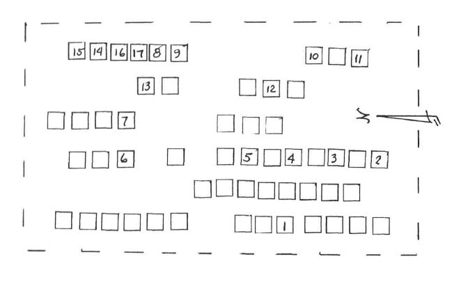
Plot number corresponds to the map in the canvass and survey from the American Indian Institute; "Our People And Where They Rest," (OPAWTR) James W. Tyner and Alice Tyner Timmons, University of Oklahoma, Norman, OK. 1969-1985 (Library of Congress No. QE99-C5-T97) Volume 1, p. 119. Cemetery was called "Stop Cemetery" at that time.
Their information (including any diagrams or maps) is given here as a historical reference and is presented "as is." Their book, like many such cemetery listing compilations, may contain errors. As with any genealogy information, this is merely a "source" and should be considered as such. It falls upon the end-user to verify the accuracy. See their map for use as a quick locator tool for graves here. The set of books are available at many Oklahoma libraries. Once freely available for online viewing, the OPAWTR volumes can now be accessed only at a LDS Family History Library, a partner library, or a Family History Center. (LDS)
NOTE: Based upon a survey done around 1970, with a visual assessment at that time; i.e., the marker WAS there at that time. Thousands of important historical records are lost to today's researchers due to the fact that there are those who won't put them up on such sites as FAG - unless the marker can be found today; ignoring the fact that tornadoes, theft or removal, vandalism, agricultural usage/abuse and other such factors, (including re-internment at a different cemetery) may well have intervened over the years, and the marker may indeed not be found today. Nevertheless, the value of submitting this memorial as a historical record is relevant and important to those who are tracing their ancestry.
Family Members
Spouse

Children

Sponsored by Ancestry
Advertisement
Explore more
Sponsored by Ancestry
Advertisement