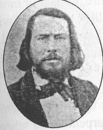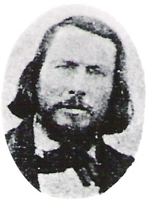
Anne Sophia married Sidney Marcus Beckstead (6/11/1815) and had 10+ children. He died on the plains of Nebraska along the Platte River.
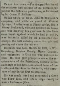
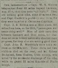
Deseret News 1864-09-21 - "On his return in Capt. John R. Murdock's company, and while on guard at Mineral Springs, 12 miles west of Platte bridge, Elder Sidney Beckstead, who had mounted his horse and was drawing his gun towards him from some brush against which he had placed it, was instantly killed by its accidental discharge, the ball entering under the right and passing out above the left ear.
Not really sure which cemetery. The only information available is - "On the plains of Nebraska" - "14 miles west of Platte River Bridge (or Platte's Bridge), Nebraska", "14 miles from Platte River Bridge, Colorado", and "Bridge Colony, Colorado". Any additional information would be very helpful.
Based on this information of the web, it could be Wyoming????? http://www.rootsweb.ancestry.com/~wytttp/history/bartlett/chapter21.htm
CAMPING PLACES IN WYOMING
Thwaites' "Early Western Travels" (Vol. XXX) gives a list of the principal camping places along the Oregon Trail, with the number of miles from each camp to the next. On the trail south of the Platte River, the first camping place in Wyoming was at Horse Creek, which was twelve miles from Scott's Blufif. On the trail north of the river the first camp was near the present Town of Torrington. From the camp on Horse Creek to Fort Laramie the distance is given as twenty-four miles. From Fort Laramie to the South Pass the best known camping grounds, with the number of miles between, are shown in the following table:
Big Springs 12
Bitter Cottonwood 10
Willow Branch 7
To Where Road Leaves the River 23
Big Timber Creek 16
Marble Creek 5
Mike's Head Creek 12
Deer Creek 16
Crossing of the North Platte 25
Mineral Springs 8
Willow Springs 5
Independence Rock 22
Devil's Gate 5
From Devil's Gate to the South Pass was 104 miles, with several good camping places along the route. Over the dividing ridge to Pacific Springs, the first camping place west of the South Pass, was five miles. From there to old Fort Bridger was 109 miles. The best camps on this part of the trail were at Little Sandy. Big Sandy, Green River and on Black's Fork. During the Oregon emigration and the rush to the California gold fields, thousands of wagons passed over this old trail and scarcely a night passed that the blaze of camp fires could not be seen at the various camping places along the road. Ox teams, mule teams and horses were used and weeks were required to make the long, tedious journey across the plains and over the mountainsâ€"a journey that is now made by rail in less than three days.
Anne Sophia married Sidney Marcus Beckstead (6/11/1815) and had 10+ children. He died on the plains of Nebraska along the Platte River.
Deseret News 1864-09-21 - "On his return in Capt. John R. Murdock's company, and while on guard at Mineral Springs, 12 miles west of Platte bridge, Elder Sidney Beckstead, who had mounted his horse and was drawing his gun towards him from some brush against which he had placed it, was instantly killed by its accidental discharge, the ball entering under the right and passing out above the left ear.
Not really sure which cemetery. The only information available is - "On the plains of Nebraska" - "14 miles west of Platte River Bridge (or Platte's Bridge), Nebraska", "14 miles from Platte River Bridge, Colorado", and "Bridge Colony, Colorado". Any additional information would be very helpful.
Based on this information of the web, it could be Wyoming????? http://www.rootsweb.ancestry.com/~wytttp/history/bartlett/chapter21.htm
CAMPING PLACES IN WYOMING
Thwaites' "Early Western Travels" (Vol. XXX) gives a list of the principal camping places along the Oregon Trail, with the number of miles from each camp to the next. On the trail south of the Platte River, the first camping place in Wyoming was at Horse Creek, which was twelve miles from Scott's Blufif. On the trail north of the river the first camp was near the present Town of Torrington. From the camp on Horse Creek to Fort Laramie the distance is given as twenty-four miles. From Fort Laramie to the South Pass the best known camping grounds, with the number of miles between, are shown in the following table:
Big Springs 12
Bitter Cottonwood 10
Willow Branch 7
To Where Road Leaves the River 23
Big Timber Creek 16
Marble Creek 5
Mike's Head Creek 12
Deer Creek 16
Crossing of the North Platte 25
Mineral Springs 8
Willow Springs 5
Independence Rock 22
Devil's Gate 5
From Devil's Gate to the South Pass was 104 miles, with several good camping places along the route. Over the dividing ridge to Pacific Springs, the first camping place west of the South Pass, was five miles. From there to old Fort Bridger was 109 miles. The best camps on this part of the trail were at Little Sandy. Big Sandy, Green River and on Black's Fork. During the Oregon emigration and the rush to the California gold fields, thousands of wagons passed over this old trail and scarcely a night passed that the blaze of camp fires could not be seen at the various camping places along the road. Ox teams, mule teams and horses were used and weeks were required to make the long, tedious journey across the plains and over the mountainsâ€"a journey that is now made by rail in less than three days.
Family Members
Parents

Siblings


Advertisement
Advertisement