Hughson Cemetery
Manitowaning, Manitoulin District, Ontario, Canada – *No GPS coordinates
About
-
Manitoulin Island
Manitowaning, Manitoulin District, Ontario CanadaNo GPS information available Add GPS
- Cemetery ID:
Members have Contributed
- 26 Memorials
- 73% photographed
- No location information available Add Location
Advertisement
Photos
No additional photos.
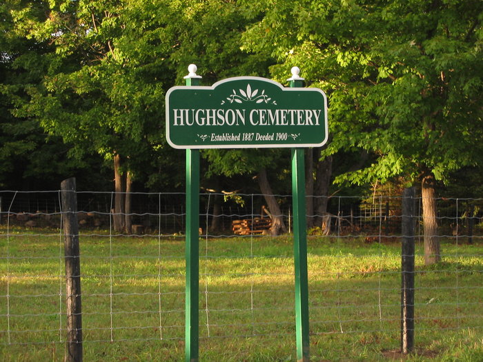
Add PhotosThe Hughson Cemetary is located on L.20, C. 1, Sheg. Twp. off the farm of Abraham and Mary Hughson on what was known as the Hughson Side Rd. This cemetary was given to the Trustees of the Manitowaning Congregation of the Methodist Church. The trustees signing were: John Phillips, Thomas Phillips, Thomas E. Walker, Thomas Leonard Hughson, and A. Hughson.
The cemetary is described as commencing at the S. E. corner of said lot and running northerly on L. 20 for 10 rods, be the same more or less, then westerly 16 rods, to the place of beginning. One acre more or less.
Although it was not deeded until 1900, the earliest stone dates back to 1887. Most of the people buried in this cemetary came from the surrounding area. There have been no buriels here since the early 1900's.
The cemetary lay neglected for many years with the fences broken so that cattle knocked down and broke most of the stones. A new gated fence was placed around the cemetary about 20 years ago. The head-stones were placed by a big tree.
In 1995, a sign was added and some more repair work done by the Municipality under Section 25.
The rest of L. 20 is still in the Hughson name after 106 years.
By bjsgd
The Hughson Cemetary is located on L.20, C. 1, Sheg. Twp. off the farm of Abraham and Mary Hughson on what was known as the Hughson Side Rd. This cemetary was given to the Trustees of the Manitowaning Congregation of the Methodist Church. The trustees signing were: John Phillips, Thomas Phillips, Thomas E. Walker, Thomas Leonard Hughson, and A. Hughson.
The cemetary is described as commencing at the S. E. corner of said lot and running northerly on L. 20 for 10 rods, be the same more or less, then westerly 16 rods, to the place of beginning. One acre more or less.
Although it was not deeded until 1900, the earliest stone dates back to 1887. Most of the people buried in this cemetary came from the surrounding area. There have been no buriels here since the early 1900's.
The cemetary lay neglected for many years with the fences broken so that cattle knocked down and broke most of the stones. A new gated fence was placed around the cemetary about 20 years ago. The head-stones were placed by a big tree.
In 1995, a sign was added and some more repair work done by the Municipality under Section 25.
The rest of L. 20 is still in the Hughson name after 106 years.
By bjsgd
Nearby cemeteries

Manitowaning, Manitoulin District, Ontario, Canada
- Total memorials19
- Percent photographed95%
- Percent with GPS84%

Hilly Grove, Manitoulin District, Ontario, Canada
- Total memorials1k+
- Percent photographed90%
- Percent with GPS36%

Gordon, Manitoulin District, Ontario, Canada
- Total memorials1k+
- Percent photographed93%
- Percent with GPS31%

Mindemoya, Manitoulin District, Ontario, Canada
- Total memorials862
- Percent photographed87%
- Percent with GPS46%
- Added: 20 May 2011
- Find a Grave Cemetery ID: 2402871

Cemetery Photos
This is a carousel with slides. Use Next and Previous buttons to navigate, or jump to a slide with the slide dots. Use Escape keyboard button or the Close button to close the carousel.
Success
Uploading...
Waiting...
Failed
This photo was not uploaded because this cemetery already has 20 photos
This photo was not uploaded because you have already uploaded 5 photos to this cemetery
This photo was not uploaded because you have already uploaded 5 photos to this cemetery
Invalid File Type
Birth and death years unknown.
1 photo picked...
2 photos picked...
Uploading 1 Photo
Uploading 2 Photos
1 Photo Uploaded
2 Photos Uploaded
Size exceeded
Too many photos have been uploaded
"Unsupported file type"
• ##count## of 0 memorials with GPS displayed. Double click on map to view more.No cemeteries found