Old Burying Ground
Groton, Middlesex County, Massachusetts, USA
About
-
Get directions Hollis Street
Groton, Massachusetts 01450 United StatesCoordinates: 42.61246, -71.57401 - townofgroton.org/Town/BoardsCommittees/OldBuryingGroundCommission.aspx
- (978) 448-1111
- Cemetery ID:
Members have Contributed
Advertisement
Photos


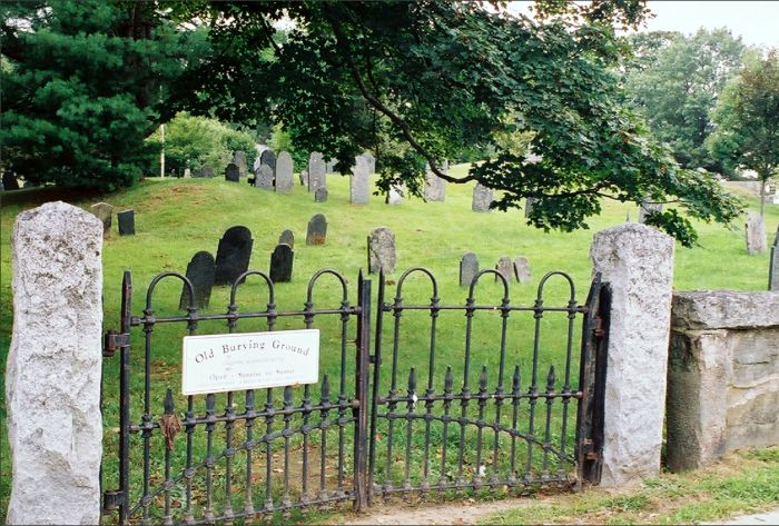
The burying ground was in use from 1678, the time of the town's re-occupation after its destruction by fire by Native Americans. At that time burial markers were either nonexistent or made of wood and so none survive from the period. The earliest stone is from 1704 and commemorates the life of James Prescott, a blacksmith.
During the Colonial Period, the appearance was that of a small cleared parcel of relatively level land with rolling mounds occupied by slate markers, most with arched tops. The Old Burying Ground retains this form despite efforts across the state during the 19th century to imitate Rural or Garden style cemeteries such as Mount Auburn in Cambridge. It contains approximately 800 recorded burials and as many as 3,000 actual burials. The boundaries form a rectangle and were fenced in stone during the 19th century. Burials continued into the early 20th century but were increasingly infrequent after the establishment in 1847 of the Groton Cemetery east of Chicopee Row.
The Old Burying Ground sits on about 4 acres. The earliest death date is 1704 with the latest c. 1900.
The Massachusetts Historical Commission refers to this cemetery in MACRIS as GRO.800 Old Burying Ground.
This cemetery is referred to as GR2 Shirley, Old Cemetery in the "Vital Records of Groton Massachusetts to the end of the year 1849.
In the early 19th century a number of tombs were built in the south-eastern corner of the cemetery and several more along the northern border of the cemetery. In the 1870's these tombs, which were in a state of disrepair, were collapsed and the tomb "caps" or inscribed lintels, were used as the top of the wall which surrounds the cemetery. Most of these are still legible and have been arranged in the order that they are mentioned in Samuel Green's "Epitaphs from the Old Burying Ground" pp227-234. The dates on these "tomb caps" reflect when the tomb was built, not when its resident died. See the cemetery photo for two tombs which were not collapsed. The wall itself is in need of repair. It is not recommended to walk, sit on or jump over the wall. Use the gates.
The boundaries of the town of Groton have changed several times since 1655 when the original land grant of the Groton Plantation was given. The original land granted originally enclosed what is now Groton and Ayer, nearly all of Pepperell and Shirley, and large portions of Littleton, as well as parts of Harvard, Westord and Nashua, NH.
Dunstable separated from Groton in 1673, Littleton in 1714, Harvard was pulled from Lancaster, Stow and Groton in 1732, Shirley in 1753, Pepperell in 1775, Ayer in 1871.
This is important, because a Groton death in 1710 (for example), could be buried in many of these towns, not necessarily in Groton Old Burying Ground.
Nearby cemeteries

Groton, Middlesex County, Massachusetts, USA
- Total memorials5k+
- Percent photographed95%
- Percent with GPS2%

Groton, Middlesex County, Massachusetts, USA
- Total memorials8
- Percent photographed100%
- Percent with GPS0%

Ayer, Middlesex County, Massachusetts, USA
- Total memorials1k+
- Percent photographed61%
- Percent with GPS10%

Pepperell, Middlesex County, Massachusetts, USA
- Total memorials1k+
- Percent photographed80%
- Percent with GPS42%
- Added: 4 Sep 2003
- Find a Grave Cemetery ID: 1969452

Cemetery Photos
This is a carousel with slides. Use Next and Previous buttons to navigate, or jump to a slide with the slide dots. Use Escape keyboard button or the Close button to close the carousel.


Success
Uploading...
Waiting...
Failed
This photo was not uploaded because this cemetery already has 20 photos
This photo was not uploaded because you have already uploaded 5 photos to this cemetery
This photo was not uploaded because you have already uploaded 5 photos to this cemetery
Invalid File Type
Birth and death years unknown.
1 photo picked...
2 photos picked...
Uploading 1 Photo
Uploading 2 Photos
1 Photo Uploaded
2 Photos Uploaded
Size exceeded
Too many photos have been uploaded
"Unsupported file type"
• ##count## of 0 memorials with GPS displayed. Double click on map to view more.No cemeteries found