Poor Farm Cemetery
Also known as Green Acres Poor Farm Cemetery
North Branch, Chisago County, Minnesota, USA
About
-
- Cemetery ID:
Members have Contributed
Advertisement
Photos


County Poor Farms held the destitute, indigent, and elderly. The residents lived a minimal existence where the physically capable individuals worked county-owned land and farmed crops to help provide their own sustenance.
This is the second Chisago County Poor Farm, established about 1885, two miles east of North Branch, MN. During the first 20 years of operation its deceased were interred at the original Poor Farm location. That first cemetery is known as the Sunrise Poor Farm or Potter's Field. Starting sometime around 1905 interments began in this North Branch Poor Farm cemetery.
The memorials in this cemetery are the identified interments at this second burial site. You will find a separate list of interments for the original Poor Farm located in Sunrise Township.
There are cement headstones for 20 persons who died between about 1905 and 1911. The markers appear to have been erected all at one time. Federal census and Chisago County death records between 1911 and 1937 reveal another five persons were buried in this cemetery in unmarked graves.
Starting about 1937 there were no more burials in this location. Although the county Poor Farms continued to operate until 1954, they began using the established local cemeteries to bury their dead.
During the 1950's the name of this county operation was changed to the Green Acres Country Care Center and relabeled as a nursing home. It sat on an 80-acre parcel of land owned by the county. The original building was later replaced with a more modern facility in the 1970's.
In the early 2000's a new private care facility was built on the west side of North Branch, the existing residents were relocated, and the old site was abandoned. Several land ownership transactions took place and eventually most the property was sold to a developer for residential home sites. On the 2015 GIS plat maps, the north, west, and southern skirts of the development area is owned by the City of North Branch.
Because of the vigorous efforts of the the cemetery remained undisturbed, unlike the original Poor Farm cemetery at Sunrise.
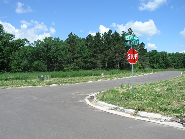
You will find this cemetery about 200 feet northwest of the Harder Avenue and Heritage Lane intersection. There was no signage until recently (2016). It can be seen from the paved dead-end cul-de-sac.
In the photo to the right, the grave site markers will be found about 50 feet into the treeline (in the center of the middle photo). A recent visit (27-Aug-2011) by a Find-A-Grave volunteer found the grounds mowed, trimmed, and well kept.
This site was one of several Poor Farm histories featured on a Minnesota Public Radio documentary in 2002:
This radio broadcast reveals examples of the almshouse system in other parts of Minnesota, but used throughout the United States in the 1800's and early 1900's. The program is narrated by Earl W. Leaf, a retired teacher, renowned Swedish historian, and a prolific author of many Chisago County Historical Society library materials.
You can find additional information on the following website is dedicated to the hidden stories found in other poor houses across the United States:
Cemetery established: 1905
Cemetery status: Inactive
Cemetery type: Poor Farm
Location: Branch
Township: T35N
Range: R21W
Section: 22
Loren Magnison was identified in 2017 as the current volunteer groundskeeper of this cemetery. He assumed this responsibility after the last remnants of the Green Acres Care facility was demolished.
Cemetery bio: [email protected]
County Poor Farms held the destitute, indigent, and elderly. The residents lived a minimal existence where the physically capable individuals worked county-owned land and farmed crops to help provide their own sustenance.
This is the second Chisago County Poor Farm, established about 1885, two miles east of North Branch, MN. During the first 20 years of operation its deceased were interred at the original Poor Farm location. That first cemetery is known as the Sunrise Poor Farm or Potter's Field. Starting sometime around 1905 interments began in this North Branch Poor Farm cemetery.
The memorials in this cemetery are the identified interments at this second burial site. You will find a separate list of interments for the original Poor Farm located in Sunrise Township.
There are cement headstones for 20 persons who died between about 1905 and 1911. The markers appear to have been erected all at one time. Federal census and Chisago County death records between 1911 and 1937 reveal another five persons were buried in this cemetery in unmarked graves.
Starting about 1937 there were no more burials in this location. Although the county Poor Farms continued to operate until 1954, they began using the established local cemeteries to bury their dead.
During the 1950's the name of this county operation was changed to the Green Acres Country Care Center and relabeled as a nursing home. It sat on an 80-acre parcel of land owned by the county. The original building was later replaced with a more modern facility in the 1970's.
In the early 2000's a new private care facility was built on the west side of North Branch, the existing residents were relocated, and the old site was abandoned. Several land ownership transactions took place and eventually most the property was sold to a developer for residential home sites. On the 2015 GIS plat maps, the north, west, and southern skirts of the development area is owned by the City of North Branch.
Because of the vigorous efforts of the the cemetery remained undisturbed, unlike the original Poor Farm cemetery at Sunrise.
You will find this cemetery about 200 feet northwest of the Harder Avenue and Heritage Lane intersection. There was no signage until recently (2016). It can be seen from the paved dead-end cul-de-sac.
In the photo to the right, the grave site markers will be found about 50 feet into the treeline (in the center of the middle photo). A recent visit (27-Aug-2011) by a Find-A-Grave volunteer found the grounds mowed, trimmed, and well kept.
This site was one of several Poor Farm histories featured on a Minnesota Public Radio documentary in 2002:
This radio broadcast reveals examples of the almshouse system in other parts of Minnesota, but used throughout the United States in the 1800's and early 1900's. The program is narrated by Earl W. Leaf, a retired teacher, renowned Swedish historian, and a prolific author of many Chisago County Historical Society library materials.
You can find additional information on the following website is dedicated to the hidden stories found in other poor houses across the United States:
Cemetery established: 1905
Cemetery status: Inactive
Cemetery type: Poor Farm
Location: Branch
Township: T35N
Range: R21W
Section: 22
Loren Magnison was identified in 2017 as the current volunteer groundskeeper of this cemetery. He assumed this responsibility after the last remnants of the Green Acres Care facility was demolished.
Cemetery bio: [email protected]
Nearby cemeteries

North Branch, Chisago County, Minnesota, USA
- Total memorials1k+
- Percent photographed87%
- Percent with GPS3%

North Branch, Chisago County, Minnesota, USA
- Total memorials643
- Percent photographed93%
- Percent with GPS18%

North Branch, Chisago County, Minnesota, USA
- Total memorials451
- Percent photographed91%
- Percent with GPS29%

Harris, Chisago County, Minnesota, USA
- Total memorials978
- Percent photographed91%
- Percent with GPS2%
- Added: 21 Jun 2008
- Find a Grave Cemetery ID: 2265837

Cemetery Photos
This is a carousel with slides. Use Next and Previous buttons to navigate, or jump to a slide with the slide dots. Use Escape keyboard button or the Close button to close the carousel.


Success
Uploading...
Waiting...
Failed
This photo was not uploaded because this cemetery already has 20 photos
This photo was not uploaded because you have already uploaded 5 photos to this cemetery
This photo was not uploaded because you have already uploaded 5 photos to this cemetery
Invalid File Type
Birth and death years unknown.
1 photo picked...
2 photos picked...
Uploading 1 Photo
Uploading 2 Photos
1 Photo Uploaded
2 Photos Uploaded
Size exceeded
Too many photos have been uploaded
"Unsupported file type"
• ##count## of 0 memorials with GPS displayed. Double click on map to view more.No cemeteries found