McClain Cemetery
Madison County, Arkansas, USA
About
-
- Cemetery ID:
Members have Contributed
Advertisement
Photos


Part of the Northeast of the Northeast ¼, Section 9, Township 18 North, Range 25 West, described as beginning at the Northeast corner of NE ¼ NE ¼, then South 283'; West 170'; North 283'; East 170' to the point of beginning; containing 1 acre more or less.
Driving directions - This cemetery is located in Madison County, however you must drive into Carroll County and then into Madison County to reach the cemetery:
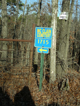
At Marble, Arkansas; take Highway 412 East for 2 ½ miles; turn North on Highway 21; continue on Highway 21 for about 5 miles. Turn left onto Carroll County Road #516 (White Oak Road). Stay on #516 for about 3 miles, until you come to a crossroad which is Carroll County Road #518 - stay on #516 for just a short distance further. Take the next road to the right, Carroll County Road #545. Stay on Carroll Co. #545 for about 2 miles, until you come to a T (#541 goes to the right). Go left on Carroll Co. #543 – you will pass through chicken houses on both the left & right. Stay on Carroll Co. road #543 which changes to Madison County #1725 when it enters Madison County; go approx. 1 ½ - 1 ¾ miles). To your left you will see Madison County #1715 - there is also a County Road sign saying "McClain Cemetery" and a locked gate. McClain Cemetery is 1.1 miles down #1715 through the locked gate. From Highway #21, it is a total of 7.8 miles to McClain Cemetery
Part of the Northeast of the Northeast ¼, Section 9, Township 18 North, Range 25 West, described as beginning at the Northeast corner of NE ¼ NE ¼, then South 283'; West 170'; North 283'; East 170' to the point of beginning; containing 1 acre more or less.
Driving directions - This cemetery is located in Madison County, however you must drive into Carroll County and then into Madison County to reach the cemetery:
At Marble, Arkansas; take Highway 412 East for 2 ½ miles; turn North on Highway 21; continue on Highway 21 for about 5 miles. Turn left onto Carroll County Road #516 (White Oak Road). Stay on #516 for about 3 miles, until you come to a crossroad which is Carroll County Road #518 - stay on #516 for just a short distance further. Take the next road to the right, Carroll County Road #545. Stay on Carroll Co. #545 for about 2 miles, until you come to a T (#541 goes to the right). Go left on Carroll Co. #543 – you will pass through chicken houses on both the left & right. Stay on Carroll Co. road #543 which changes to Madison County #1725 when it enters Madison County; go approx. 1 ½ - 1 ¾ miles). To your left you will see Madison County #1715 - there is also a County Road sign saying "McClain Cemetery" and a locked gate. McClain Cemetery is 1.1 miles down #1715 through the locked gate. From Highway #21, it is a total of 7.8 miles to McClain Cemetery
Nearby cemeteries

Rockhouse, Madison County, Arkansas, USA
- Total memorials4
- Percent photographed75%
- Percent with GPS0%

Rockhouse, Madison County, Arkansas, USA
- Total memorials2
- Percent photographed100%
- Percent with GPS0%

Metalton, Carroll County, Arkansas, USA
- Total memorials48
- Percent photographed94%
- Percent with GPS0%
Forum, Madison County, Arkansas, USA
- Total memorials2
- Percent photographed100%
- Percent with GPS0%
- Added: 1 Jan 2000
- Find a Grave Cemetery ID: 54974

Cemetery Photos
This is a carousel with slides. Use Next and Previous buttons to navigate, or jump to a slide with the slide dots. Use Escape keyboard button or the Close button to close the carousel.


Success
Uploading...
Waiting...
Failed
This photo was not uploaded because this cemetery already has 20 photos
This photo was not uploaded because you have already uploaded 5 photos to this cemetery
This photo was not uploaded because you have already uploaded 5 photos to this cemetery
Invalid File Type
Birth and death years unknown.
1 photo picked...
2 photos picked...
Uploading 1 Photo
Uploading 2 Photos
1 Photo Uploaded
2 Photos Uploaded
Size exceeded
Too many photos have been uploaded
"Unsupported file type"
• ##count## of 0 memorials with GPS displayed. Double click on map to view more.No cemeteries found