St. Andrew's Cemetery
Also known as Saint Andrews on the Red Anglican Church Cemetery , Saint Andrews Churchyard
Saint-Andrews, Selkirk Census Division, Manitoba, Canada
About
-
Get directions 3 St Andrews Road
Saint Andrews, RM of St Andrews, Manitoba
R1A2Y1 CanadaCoordinates: 50.06674, -96.97529 - www.standrewsonthered.ca/history/
- [email protected]
- +1-204-334-5700
-
Office Address
St. Andrews on the Red Anglican Church
3 St Andrews Road
Saint Andrews, RM of St Andrews, Manitoba
R1A2Y1 Canada - Cemetery ID:
-
Additional information
Located behind the historic St. Andrews on the Red Anglican Church, in Saint Andrews, MB, at the junction of St Andrews Road and River Road. along the banks of the Red River
There is no network of improved roadways providing vehicular access to the grounds.
Burial records can be consulted by contacting the Parish Secretary.
NOTE: Many of the old stones are in poor condition, partly because of their exposure to the winds which sweep across the prairie or up from the river.
Members have Contributed
Advertisement
Photos


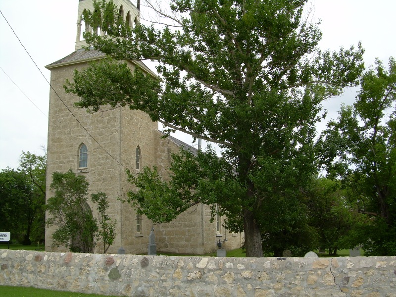
The cemetery surrounding this church is steeped in Manitoba's history. The hardships of plagues such as influenza, diphtheria, typhoid and tuberculosis are revealed as the inscriptions on the tombstones in the older part of the cemetery are read. Many people who played a role in the Red River Settlement and Manitoba's history are found in the cemetery. These people include Archdeacon Cockran, first missionary and founder of the church; E.H.G.G. Hay, the first leader of Manitoba's Official Opposition Party in 1870; Alexander Christie, Chief Factor of the Hudson Bay Company; Alexander Lillie, who operated the first successful experimental farm at Lower Fort Garry; Matilda Davis, who ran the Miss Davis School for daughters of Hudson Bay Company officials in the area; and Captain William Kennedy, Arctic Explorer who searched for Sir John Franklin's lost expedition.
(Source: St. Andrews on the Red Anglican Church website [2023/12; Adapted])
St. Andrew's on the Red is the oldest Anglican stone church in Canada, west of the Great Lakes. The Church was built between 1845 and 1849, designed by Archdeacon William Cockran and stonework done by Duncan McRae. The Church was the worship place of many of the retired Hudson's Bay employees and their families.
(Source: Manitoba Historical Society [Adapted])
~~~~~~~~~~
Dominion Land Survey coordinates: LSD04-03-13-04-E1
In the Rural Municipality of St Andrews
~~~~~~~~~~
A part of the town's story, and those of its inhabitants, from the early days of European settlement through roughly 1999 is told in the volume "Beyond the Gates of Lower Fort Garry 1880-1981", especially starting on page 57, and in the related volume "Beyond the Gates of Lower Fort Garry - A Sequel", especially starting on page 56.
Free digital versions of these and many other Manitoba local history books can be found online in the University of Manitoba Digital Collections. There is also a list of such books organized by district and town name on the Manitoba Historical Society's website on their page entitled "Finding Aid: Manitoba Local History Books".
A list of burials in this cemetery is available from the Manitoba Genealogical Society (reference#0118), transcribed by a member or members in 1984 and updated in 2001 and 2018. Also available to MGS members is a searchable online database named the "MGS Manitoba Name Index" (or MANI). Some additional information is contained in the 1996 MGS publication "Carved in Stone: Manitoba Cemeteries and Burial Sites" (revised edition, Special Projects Publication, 106 pages).
~~~~~~~~~~
The church building is recognized as a Provincial Heritage Site by the Government of Manitoba Historic Resources Branch (#053)
The rectory building is recognized as a National Heritage Site by the Government of Canada
Nearby cemeteries

Narol, Selkirk Census Division, Manitoba, Canada
- Total memorials292
- Percent photographed93%
- Percent with GPS91%

Narol, Selkirk Census Division, Manitoba, Canada
- Total memorials121
- Percent photographed98%
- Percent with GPS98%

Gonor, Selkirk Census Division, Manitoba, Canada
- Total memorials395
- Percent photographed94%
- Percent with GPS94%

Gonor, Selkirk Census Division, Manitoba, Canada
- Total memorials27
- Percent photographed78%
- Percent with GPS0%
- Added: 9 Jan 2010
- Find a Grave Cemetery ID: 2337427

Cemetery Photos
This is a carousel with slides. Use Next and Previous buttons to navigate, or jump to a slide with the slide dots. Use Escape keyboard button or the Close button to close the carousel.


Success
Uploading...
Waiting...
Failed
This photo was not uploaded because this cemetery already has 20 photos
This photo was not uploaded because you have already uploaded 5 photos to this cemetery
This photo was not uploaded because you have already uploaded 5 photos to this cemetery
Invalid File Type
Birth and death years unknown.
1 photo picked...
2 photos picked...
Uploading 1 Photo
Uploading 2 Photos
1 Photo Uploaded
2 Photos Uploaded
Size exceeded
Too many photos have been uploaded
"Unsupported file type"
• ##count## of 0 memorials with GPS displayed. Double click on map to view more.No cemeteries found